Bay of All Saints
| Baía de Todos os Santos All Saints' Bay | |
|---|---|
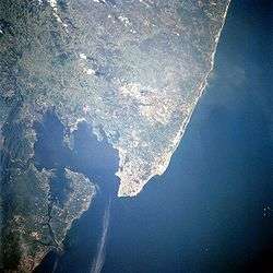 Salvador and the Bay of All Saints in April 1997 | |
| Location | Bahia, Brazil |
| Coordinates | 12°48′S 38°38′W / 12.800°S 38.633°W |
| River sources |
Paraguaçu River Subaé River Jaguaripe River |
| Ocean/sea sources | Atlantic Ocean |
| Basin countries | Brazil |
| Surface area | 1,223 square kilometers (472 sq mi) |
| Average depth | 9.8 meters (32 ft) |
| Settlements | Salvador |
| References | [1] |

The Bay of All Saints (Portuguese: Baía de Todos os Santos), also known as All Saints' Bay and Todos os Santos Bay, is the principal bay of the Brazilian state of Bahia,[2][1] to which it gave its name.[2][1] Todos os Santos Bay sits on the eastern coast of Brazil, surrounding part of Bahia's capital Salvador and opening to the Atlantic Ocean. It covers 1,223 square kilometers (472 sq mi), making it the largest bay in Brazil.
Farol da Barra (Barra Lighthouse), on the site of a historic fort, stands at the entrance of the bay.[3] The Bay of All Saints is shallow along much of its area with an average depth of 9.8 meters (32 ft). The Paraguaçu River travels 500 kilometers (310 mi) to empty into the bay and the coastal lowlands of the Reconcavo Basin are at its mouth.[2][1] It contains 91 islands, the largest being Ilha de Itaparica at its entrance.[1]
History
The Italian explorer Amerigo Vespucci was the first European to visit the bay, during his second expedition to the Americas. He entered the bay on All Saints' Day (November 1), 1501.[4] He named the Bay of the Holy Savior of All the Saints after the date and his parish church in Florence, San Salvatore di Ognissanti.[5] Initially, the bay, its principal settlement, and the captaincy around it all shared the same name, but they were eventually distinguished, the state becoming simply Bahia, the bay becoming the Bay of All Saints, and the city becoming first Bahia and now (usually) Salvador.
In 1501, one year after the arrival of Pedro Álvares Cabral's fleet in Porto Seguro, Gaspar de Lemos arrived at the Bay of All Saints and sailed most of the Bahia coast. The first European to disembark in Morro de São Paulo was Martim Afonso de Sousa in 1531, while he was leading an expedition charged with exploring the coast of the new continent.
Salvador was a major slave port for the sugarcane fields of Brazil by the early 18th century.[2] In the whaling days, it was also a popular spot, since the bay was a mating ground for whales.
The northeast shore of the Bay of All Saints is home to Brazil's first active oil fields. The municipality of São Francisco do Conde, at the north of the bay, remains a port that serves the oil refineries at Mataripe. The bay is dredged from the port to the Atlantic Ocean to remain open to shipping.[2]
References
Citations
- 1 2 3 4 5 Cirano, Mauro; Lessa, Guilherme Camargo (2007). "Oceanographic Characteristics Of Baía De Todos Os Santos, Brazil" (PDF). Revista Brasileira de Geofísica. Sociedade Brasileira de Geofísica. 25 (4): 363–387.
- 1 2 3 4 5 "Todos os Santos Bay". Encyclopaedia Britannica. Encyclopaedia Britannica. 2014. Retrieved 15 December 2014.
- ↑ "Histórico" [History]. Barra, Salvador: Museu Náutico da Bahia. 2014. Retrieved 15 December 2014. (Portuguese)
- ↑ "Américo Vespúcio". UOL Educaçao. 2014. Retrieved 15 December 2014. (Portuguese)
- ↑ Bargellini & al. (1977), pp. 337-340.
Bibliography
- Bargellini, Piero; et al. (1977), Le Strade di Firenze, Vol. II, Florence: Bonechi. (Italian)
External links
- "Plano de la Bahia de todos Santos situada en la costa meridional del Brasil", a 19th-century Spanish map of the Bay of All Saints
Coordinates: 12°48′S 38°38′W / 12.800°S 38.633°W