Baghdad Metro
| Overview | |||
|---|---|---|---|
| Owner | Iraqi Republic Railways | ||
| Locale |
| ||
| Transit type | Commuter rail | ||
| Number of lines | 2 | ||
| Number of stations | 41 | ||
| Operation | |||
| Began operation | 2008 | ||
| Technical | |||
| System length | 24 km (14.9 mi) | ||
| Track gauge | 1,435 mm (4 ft 8 1⁄2 in) | ||
| |||
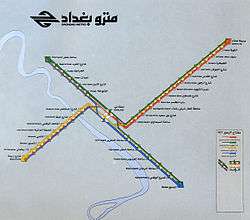
The Baghdad Metro is a surface commuter train that operates in the Iraqi city of Baghdad. It is operated by the state owned Iraqi Republic Railways. It resumed operation in October, 2008. The train runs about 24 kilometres (15 mi) between Baghdad Central Station and the southern neighborhood of Dora. It operates two round trips a day, one in the morning and one in the afternoon. The Baghdad Metro and the passenger train that runs between Baghdad and Basra, which resumed service in 2007, were the first two regular passenger services to resume in Iraq since the Iraq War.[1]
The Baghdad Metro's rolling stock entered service in 1983.[1]
In February 2009 Iraqi Republic Railways introduced a passenger service between Baghdad and Fallujah. IRR intends in future to extend the service to Ramadi.[2]
| Line 1 | Line 2 |
|---|---|
|
|
Politics
Saddam Hussein launched the multi-billion-dollar subway project in 1983 to alleviate traffic congestion in Baghdad's streets. During the Iran-Iraq war the subway project was halted.[3]
At a December 2002 press conference, Defense Secretary Donald Rumsfeld spoke of "enormous miles and miles and miles of underground tunneling" that prevented the United Nations from properly inspecting Saddam's WMD stocks.[4] Hussein al-Shahristani, a scientist imprisoned by Saddam, told CBS's 60 Minutes, "We believe now it is more than 100 kilometers of very complex network, multilayer tunnels." [4]
Future expansion
Since the 2003 Iraq War, traffic problems in Baghdad have increased significantly, because of the creation of the Green Zone, and the reduction of car-ownership regulation.[5] In November 2008, Baghdad mayor Sabir al-Isawi announced plans for a 2-line $US 3 billion expansion of metro services in the city which would be built pending funding. One line would run from Sadr City (previously called Al-Thawra or Saddam City) to A'dhamiya, while the other would link the center of Baghdad with its western suburbs. Each line would have 20 stations.[6] In February 2011, an agreement was signed with Alstom, for the construction of a 25 km line from central Baghdad to the northern suburbs of Adhamiya, Al-Hurriya, Kadhimiya, and Sha'ab.[7] Later in 2011 Alstom and the Iraqi government signed a memorandum of understanding (MOU) for Alstom to design, build and operate a Baghdad–Basra high-speed rail line.[8]
References
- 1 2 Tina Susman and Caesar Ahmed (November 18, 2008). "All aboard the Baghdad Metro". Los Angeles Times.
- ↑ Hugh Tomlinson (February 10, 2009). "Iraq reopens passenger railway from Baghdad to Falluja". MEED.
- ↑ Brian McWilliams. "The Collapse of Saddam's Secret Subway". Antiwar.com. Retrieved 2010-04-26.
- 1 2 Pike, John. "U.S. Forces Investigate Iraqi Tunnels". GlobalSecurity.org. Retrieved 2010-04-26.
- ↑ "Baghdad Metro". The Digital Journalist. Retrieved 2010-04-26.
- ↑ Martin Chulov (November 19, 2008). "From roads to ruin, Baghdad gets back on track". The Age.
- ↑ "BAGHDAD METRO". Railways Africa. Archived from the original on 2011-07-15. Retrieved 2011-02-19.
- ↑ "Alstom tapped for Iraq HSR talks". Railway Age. 24 June 2011. Archived from the original on 27 June 2011. Retrieved 27 June 2011.