Badinières
| Badinières | |
|---|---|
 | |
 Badinières | |
|
Location within Auvergne-Rhône-Alpes region  Badinières | |
| Coordinates: 45°30′36″N 5°18′11″E / 45.51°N 5.3031°ECoordinates: 45°30′36″N 5°18′11″E / 45.51°N 5.3031°E | |
| Country | France |
| Region | Auvergne-Rhône-Alpes |
| Department | Isère |
| Arrondissement | La Tour-du-Pin |
| Canton | Bourgoin-Jallieu-Sud |
| Government | |
| • Mayor (2001–2020) | Alain Berger |
| Area1 | 5.99 km2 (2.31 sq mi) |
| Population (2010)2 | 606 |
| • Density | 100/km2 (260/sq mi) |
| Time zone | CET (UTC+1) |
| • Summer (DST) | CEST (UTC+2) |
| INSEE/Postal code | 38024 / 38300 |
| Elevation | 396–550 m (1,299–1,804 ft) |
|
1 French Land Register data, which excludes lakes, ponds, glaciers > 1 km² (0.386 sq mi or 247 acres) and river estuaries. 2 Population without double counting: residents of multiple communes (e.g., students and military personnel) only counted once. | |
Badinières is a French former commune in the Isère department in the Rhône-Alpes region of south-eastern France. In January 2015 it merged with Eclose, forming the new commune Eclose-Badinières.
The inhabitants of the commune are known as Badiniérois or Badiniéroises.[1]
Geography
Badinières is located some 45 km south-east of Lyon and 10 km south of Bourgoin-Jallieu. Access to the commune is by the D1085 road from Bourgoin-Jallieu in the north which passes through the heart of the commune and the village before continuing south to Eclose. Apart from some forest along the eastern border the commune is entirely farmland.[2]
The Agny river forms the north-western border of the commune as it flows north-east to join the Bourbre in Nivolas-Vermelle. The Ruisseau de Barthgolomat rises north of the village and flows north-west to join the Agny on the northern border of the commune.[2]
Neighbouring communes and villages[3]
 |
Les Éparres | | ||
| Tramolé | |
Châteauvilain | ||
| ||||
| | ||||
| Eclose |
History
The commune was created in 1857 from the commune of Les Éparres.[4]
There were Agricultural Shows in 1991 and on 26–27 August 2006.
Administration
| From | To | Name | Party | Position |
|---|---|---|---|---|
| 1983 | 1995 | Robert Porcher | ||
| 2001 | 2020 | Alain Berger |
(Not all data is known)
Demography
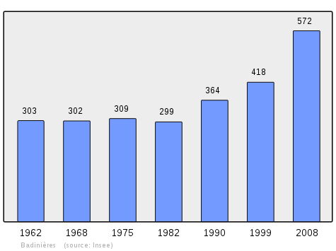
In 2010 the commune had 606 inhabitants. The evolution of the number of inhabitants is known from the population censuses conducted in the commune since 1861 (after the creation of the commune in 1857). From the 21st century, a census of communes with fewer than 10,000 inhabitants is held every five years, unlike larger communes that have a sample survey every year.[Note 1]
| 1856 | 1861 | 1866 | 1872 | 1876 | 1881 | 1886 | 1891 | 1896 |
|---|---|---|---|---|---|---|---|---|
| 477 | 507 | 467 | 424 | 429 | 406 | 428 | 406 |
| 1901 | 1906 | 1911 | 1921 | 1926 | 1931 | 1936 | 1946 | 1954 |
|---|---|---|---|---|---|---|---|---|
| 391 | 376 | 357 | 313 | 335 | 320 | 312 | 304 | 298 |
| 1962 | 1968 | 1975 | 1982 | 1990 | 1999 | 2006 | 2010 | - |
|---|---|---|---|---|---|---|---|---|
| 303 | 302 | 309 | 299 | 364 | 418 | 510 | 606 | - |
Sources : Ldh/EHESS/Cassini until 1962, INSEE database from 1968 (population without double counting and municipal population from 2006)
Sites and monuments
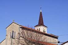
- A Church from the 19th century
See also
External links
- Badinières official website (French)
- Badinières on the old National Geographic Institute website (French)
- Badinières on Lion1906
- Badinières on Google Maps
- Badinières on Géoportail, National Geographic Institute (IGN) website (French)
- Badiniere on the 1750 Cassini Map
- Badinières on the INSEE website (French)
- INSEE (French)
Notes and references
Notes
- ↑ At the beginning of the 21st century, the methods of identification have been modified by Law No. 2002-276 of 27 February 2002, the so-called "law of local democracy" and in particular Title V "census operations" allows, after a transitional period running from 2004 to 2008, the annual publication of the legal population of the different French administrative districts. For communes with a population greater than 10,000 inhabitants, a sample survey is conducted annually, the entire territory of these communes is taken into account at the end of the period of five years. The first "legal population" after 1999 under this new law came into force on 1 January 2009 and was based on the census of 2006.
References
- ↑ Inhabitants of Isère (French)
- 1 2 Google Maps
- ↑ Géoportail, IGN (French)
- ↑ Ldh/EHESS/Cassini Communal Notice (French)
- ↑ List of Mayors of France (French)
| Wikimedia Commons has media related to Badinières. |