Badaroux
| Badaroux | ||
|---|---|---|
|
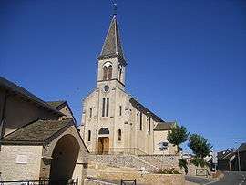
The church in Badaroux | ||
| ||
 Badaroux | ||
|
Location within Occitanie region  Badaroux | ||
| Coordinates: 44°32′15″N 3°33′02″E / 44.53750°N 3.5506°ECoordinates: 44°32′15″N 3°33′02″E / 44.53750°N 3.5506°E | ||
| Country | France | |
| Region | Occitanie | |
| Department | Lozère | |
| Arrondissement | Mende | |
| Canton | Mende-Nord | |
| Intercommunality | Haute Vallée d'Olt | |
| Government | ||
| • Mayor (2008–2014) | Régis Turc | |
| Area1 | 20.72 km2 (8.00 sq mi) | |
| Population (2009)2 | 897 | |
| • Density | 43/km2 (110/sq mi) | |
| Time zone | CET (UTC+1) | |
| • Summer (DST) | CEST (UTC+2) | |
| INSEE/Postal code | 48013 / 48000 | |
| Elevation |
736–1,220 m (2,415–4,003 ft) (avg. 800 m or 2,600 ft) | |
|
1 French Land Register data, which excludes lakes, ponds, glaciers > 1 km² (0.386 sq mi or 247 acres) and river estuaries. 2 Population without double counting: residents of multiple communes (e.g., students and military personnel) only counted once. | ||

Badaroux (Badarosc in Occitan) is a commune in the Lozère department in southern France.

Population
| Historical population | ||
|---|---|---|
| Year | Pop. | ±% |
| 1793 | 672 | — |
| 1800 | 672 | +0.0% |
| 1806 | 645 | −4.0% |
| 1821 | 658 | +2.0% |
| 1831 | 742 | +12.8% |
| 1836 | 750 | +1.1% |
| 1841 | 705 | −6.0% |
| 1846 | 721 | +2.3% |
| 1851 | 688 | −4.6% |
| 1856 | 715 | +3.9% |
| 1861 | 668 | −6.6% |
| 1866 | 674 | +0.9% |
| 1872 | 669 | −0.7% |
| 1876 | 657 | −1.8% |
| 1881 | 664 | +1.1% |
| 1886 | 726 | +9.3% |
| 1891 | 669 | −7.9% |
| 1896 | 864 | +29.1% |
| 1901 | 649 | −24.9% |
| 1906 | 674 | +3.9% |
| 1911 | 552 | −18.1% |
| 1921 | 510 | −7.6% |
| 1926 | 491 | −3.7% |
| 1931 | 507 | +3.3% |
| 1936 | 470 | −7.3% |
| 1946 | 448 | −4.7% |
| 1954 | 403 | −10.0% |
| 1962 | 372 | −7.7% |
| 1968 | 426 | +14.5% |
| 1975 | 689 | +61.7% |
| 1982 | 939 | +36.3% |
| 1990 | 905 | −3.6% |
| 1999 | 850 | −6.1% |
| 2009 | 897 | +5.5% |
See also
References
| Wikimedia Commons has media related to Badaroux. |
This article is issued from Wikipedia - version of the 2/11/2016. The text is available under the Creative Commons Attribution/Share Alike but additional terms may apply for the media files.