Backbone Trail
| Backbone Trail | |
|---|---|
|
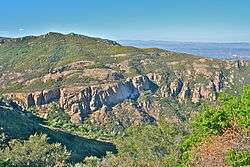
The Backbone Trail between Will Rogers State Historic Park and Trippet Ranch in Topanga State Park | |
| Length | 67.79 mi (109.1 km) |
| Location | Los Angeles County / Ventura County, California, USA |
| Trailheads | Point Mugu State Park / Will Rogers State Historic Park |
| Use | Hiking, Cycling, Horseback Riding |
| Elevation | |
| Highest point | Sandstone Peak |
| Lowest point | Pacific Ocean |
| Hiking details | |
| Trail difficulty | Moderate to Strenuous |
| Season | Year-round |
| Sights | Santa Monica Mountains |
| Hazards |
Mountain lions Poison Oak Venomous snakes |

The Backbone Trail is a long distance trail extending 67.79 miles[1] (109.10 km) across the length of the Santa Monica Mountains in the U.S. state of California. Its western terminus is Point Mugu State Park and its eastern terminus is Will Rogers State Historic Park in Pacific Palisades. The trail is open to hikers throughout its length; dogs, mountain bicyclists and horseback riders are allowed on portions of the trail as posted.[2]
History
Construction on the backbone trail began in the early 1980s, and involved the cooperation of the National Park Service, the California Department of Parks and Recreation, and private parties interested in connecting existing trails within the Santa Monica Mountains NRA into a single trail spanning the length of the park.[3] The range of conditions found on the trail - ranging from flat, wide fire roads to narrow single-track trails - reflects the trail's origin as a series of unconnected paths and backcountry roads, connected to form the Backbone Trail System.
In 2016, the National Park Service completed land acquisitions from former California Governor Arnold Schwarzenegger and fitness pioneer Betty Weider to enable right-of-way for the trail.[4] In May 2016, a new section of the trail was completed on the east side of Yerba Buena Road in support of these acquisitions.
The official opening ceremony for the Backbone Trail was held on Saturday, June 4, 2016 at Will Rogers State Park, from 9:00am to 12:00pm, with a ribbon-cutting ceremony held at 10:00am.[5]
Topography and geography
As the Backbone Trail passes over the peaks and through the canyons of the Santa Monica Mountains, it climbs and falls in elevation nearly constantly. From its lowest point, the sea-level Ray Miller Trailhead at Point Mugu State Park, to its highest point, Sandstone Peak (which, at 3,111 ft (948 m), is the highest peak in the Santa Monica Mountains), the trail is more frequently graded than level.
Scenic views of Ventura County are seen from the six-mile loop trail, starting at the trailhead off Yerba Buena road. The Mishe Mokwa Trail in Circle X Ranch follows Carlisle Canyon along Boney Mountain past weathered red volcanic formations. There are views of the sculpted caves and crevices of Echo Cliffs and a forested streamside picnic area by a huge split boulder known as Split Rock. The return route on the Backbone Trail leads to Inspiration Point and culminates at Sandstone Peak, the highest point in the Santa Monica Mountains. Both points overlook the Pacific Ocean, the Channel Islands, and the surrounding mountains.[6]
Parts of the trail lie within the city limits of Los Angeles and Malibu, California; the rest sits in unincorporated areas of Los Angeles County and Ventura County. The following national, state, and privately administered wilderness areas are traversed by the Backbone Trail:
- Will Rogers State Historic Park
- Santa Monica Mountains National Recreation Area
- Topanga State Park
- Cold Creek Canyon Preserve - owned by the Mountains Restoration Trust.
- Malibu Creek State Park
- Point Mugu State Park
Environment
Like the surrounding Santa Monica Mountains, the Backbone Trail System belongs to the California chaparral and woodlands and California coastal sage and chaparral ecoregions, and a wide range of flora and fauna can be observed from the trail.
Flora
For the majority of its length, the Backbone Trail passes through terrain occupied by the ground-hugging bushes and shrubs that characterize the coastal sage scrub and chaparral ecosystems. Relatively few trees line the trail, an important consideration for travellers looking for shade.
Fauna
More than 450 vertebrate species have been observed within the Santa Monica Mountains NRA,[7] including more than 380 species of birds.[8] Lizards, seven species of which inhabit areas surrounding the trail,[9] are particularly numerous, and can be easily found on or alongside the trail. Southern Pacific rattlesnakes can be numerous in early spring, particularly along Temescal Ridge in the eastern section of the trail. Mountain lions have been observed in the western section near Sandstone Peak trailhead in June 2008. At least eight mountain lions are believed to remain from Pt. Mugu to Topanga State Park. Notable species that can found along the Backbone trail include:
- Bobcat
- California Kingsnake
- Coyote
- Mountain lion
- Pacific treefrog
- Peregrine falcon
- Red-tailed hawk
- Southern Pacific rattlesnake
See also
- Santa Monica Mountains National Recreation Area
- Malibu Creek State Park
- Topanga State Park
- Mulholland Highway
- Point Mugu State Park
- Sandstone Peak
References
- ↑ Backbone Trail System Milage/GPS Chart, National Park Service Archived 16 February 2010 at the Wayback Machine.
- ↑ Santa Monica Mountains NRA - Backbone Trail (U.S. National Park Service). Accessed June 9, 2010.
- ↑ Santa Monica Mountains NRA - Backbone Trail (U.S. National Park Service). Accessed August 27, 2007.
- ↑ You can now hike 67 miles through the Santa Monica Mountains uninterrupted, Los Angeles Times. Accessed June 13, 2016.
- ↑ Backbone Trail to officially open with ceremony Saturday, Ventura County Star. Accessed June 13, 2016.
- ↑ Day Hikes Around Ventura County, Stone. 2003 p. 96
- ↑ NPS.gov - Santa Monica Mountains NRA: Animals. Accessed August 27, 2007.
- ↑ NPS.gov - Santa Monica Mountains NRA: Birds. Accessed August 27, 2007.
- ↑ NPS.gov - Santa Monica Mountains NRA: Lizards. Accessed August 27, 2007.
External links
- Official Backbone Trail Website
- Map of the Backbone Trail System from the US National Park Service
- Complete List of Backbone Trail System Trailheads and Mile Markers from the US National Park Service
- California Coast Trail.org - Backbone Trail
- Backbone Trail Mountain Biking Reviews from MTBR.com
Coordinates: 34°07′10″N 118°56′15″W / 34.11944°N 118.93750°W