Baccalieu Island
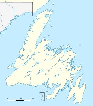 Baccalieu Island Location of Baccalieu Island in Newfoundland | |
| Geography | |
|---|---|
| Coordinates | 48°07′49″N 52°48′05″W / 48.13028°N 52.80139°WCoordinates: 48°07′49″N 52°48′05″W / 48.13028°N 52.80139°W |
| Area | 5 km2 (1.9 sq mi) |
| Highest elevation | 137 m (449 ft) |
| Highest point | |
| Administration | |
|
Canada | |
| Province | Newfoundland and Labrador |
| Demographics | |
| Population | 0 |
|
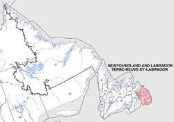
Newfoundland | |
| Location |
Baccalieu Island Avalon Peninsula Newfoundland and Labrador Canada |
|---|---|
| Coordinates | 48°09′00″N 52°47′55″W / 48.149981°N 52.798524°W |
| Year first constructed | 1859 (first) |
| Year first lit | 1990s (current) |
| Construction |
brick tower covered by iron plates since 1893 with balcony and lantern (first) steel skeletal towe] (current) |
| Tower shape |
cylindrical tower with balcony and lantern (first) triangular prism tower |
| Markings / pattern |
rusty color tower (first) white tower (current) |
| Height |
11 metres (36 ft) (first) 13.5 metres (44 ft) (current) |
| Focal height | 166 metres (545 ft) (current) |
| Light source | solar power |
| Characteristic | Fl W 6s. |
| Admiralty number | H0498 |
| CHS number | CCG 472 |
| NGA number | 1736 |
| ARLHS number | CAN-647 |
| Managing agent | Baccalieu Island Ecological Reserve [1] |
Baccalieu Island is a 5 km2 uninhabited island at the northern extremities of Conception Bay in Subdivision 1G, near the community of Red Head Cove, Canada. It is separated from the island of Newfoundland by Baccalieu Tickle, a small strait and an abundant fishing ground.
The name Baccalieu is derived either from the Portuguese bacalhau, Spanish bacalao or the Basque baccalos, all meaning "codfish". Early Portuguese maps dating before Columbus' voyage indicate an island east of the Azores named Terra do Bacalhau which may have been the whole island of Newfoundland. Modern Baccalieu Island was known to Europeans by that name since at least 1556, when it was drawn on the Gastaldi map as "Bacalaos".[2]
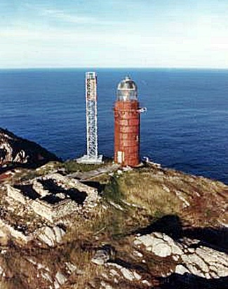
Lighthouses
Historically, two lighthouses were operated on Baccalieu Island; today both are automated. The lighthouse on the northern end is not operational any more; its light was extinguished in the early 1990s. This lighthouse was replaced as an aid to navigation by an automated light on a skeletal tower. It was originally a brick tower and was later encased in iron. The old tower's data:
- Tower height: 36 feet (11 m)
- Height of focal plane: 443 feet (135 m)
- Description: Red, conical cast iron
- Date established: 1859
- Date present tower built: 1858
- Date deactivated: 1990s
- Current use: Unknown
- Open to public? No
Four generations of the Ryan family "kept the light" at Baccalieu from 1858 to 1950. Other keepers at Baccalieu included Felix Noonan, Eric Blundon, John Hyde, Linus Walsh, Joseph Hatch, Pat Rice, and principal lightkeeper Raymond Hyde.
Ecological Reserve
- Main article: Baccalieu Island Ecological Reserve
Baccalieu Island is the largest seabird island in Newfoundland and supports the greatest diversity of breeding seabirds in eastern North America. The island supports the largest known colony of Leach's storm-petrel in the world, approximately 40% of the global population and about 70% of the western Atlantic population of this species. It is a nesting area for 11 breeding species:
- Atlantic puffin (45,000 pairs - approximately 12% of the eastern North America population)
- Black-legged kittiwake (13,000 - approximately 5 to 7% of the western Atlantic breeding population); and
- Northern gannet (677 pairs - approximately 1.5% of the North American population).
- Northern fulmar
- Black guillemot
- Common murre
- Thick-billed murre
- Razorbill
- Herring gull
- Great black-backed gull
- The island also includes one of the largest winter populations of eider in Newfoundland.
The island has a surface of 5 km2, and the reserve spans 23 km2, including all of the island and one kilometer of ocean around the coast.
See also
- List of lighthouses in Newfoundland and Labrador
- List of lighthouses in Canada
- "The Cliffs of Baccalieu"
Notes
- ↑ Rowlett, Russ. "Lighthouses of Southeast Newfoundland". The Lighthouse Directory. University of North Carolina at Chapel Hill. Retrieved December 29, 2015.
- ↑ The Gastaldi map
External links
- Baccalieu Trail
- Historical Baccalieu Trail
- Newfoundland Heritage Site
- Lighthouse Digest
- Baccalieu Island Ecological Reserve homepage
- PDF map of the island and the reserve
- Picture of Ballalieu Island Lighthouse