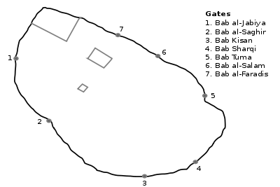
Bab al-Jabiyah
Bab al-Jabiya (Arabic: باب الجابية; Gate of the Water Trough) or the Gate of Jupiter is one of the seven ancient city-gates of Damascus, Syria. Bab al-Jabiya was the main entrance on the city's west side. The gate opens on Medhat Pasha Souq, which is the modern western half of the Street Called Straight, the Roman east-west artery (decumanus), which still connects it to Bab Sharqi (the Roman "Gate of the Sun").[1] The gate's modern name dates to the Umayyad period and comes from the name of al-Jabiya in the Golan Heights, then the capital city of the Ghassanids, allies of the Roman Empire.[2]
History
During Roman times the gate was a typical tripartite gate with three entrances; a central carriageway for wheeled vehicles, flanked by two pedestrian entrances.[3] Close to the gate is where the Roman Temple of Jupiter and the Theatre of Herod the Great (modern Bayt al-Aqqad), once stood.[4]
Damascus was conquered by Muslims In the Rashidu era. During the Siege of Damascus, the Muslim general Abu Ubaidah ibn al Jarrah, entered Damascus peacefully through this gate on 18 September 634. He met the forces of Khalid ibn al-Walid, which entered the city by force from the Bab Sharqi, halfway through the Street Called Straight, near the present day Mariamite Cathedral of Damascus.[5] Under Muslim rule, the gate was partially blocked except for a small pedestrian opening. It was rebuilt during the reign of Nur ad-Din Zangi, and the date was inscribed as 567 Hijri (1171-1172 AD). Other inscriptions reveal that it was renovated again under the Ayyubid Sultan al-Malik al-Mu'azzam, and again under the Mamluks in 687 Hijri (1288-1289 AD).[3]
References
- ↑ Wallace, Richard; Williams, Wynne (1998). The Three Worlds of Paul of Tarsus. Routledge. p. 163. ISBN 0-415-13592-3.
- ↑ Toponymy, Monuments, Historical Geography and Frontier Studies. 21. Dumbarton Oaks. 2002. p. 102. ISBN 0-88402-284-6.
- 1 2 Joud Allah, Fatima. باب الجابية في دمشق (in Arabic). Discover Syria. Retrieved 19 February 2011.
- ↑ "The Straight Street". Tullab wa Shabab. 3 February 2011. Retrieved 19 February 2011.
- ↑ Burns, Ross (2005). Damascus: A History. Routledge. p. 99. ISBN 0-415-27105-3.
|
|---|
|
| |
|
| |
|---|
| | Districts: |
- Al-Abbas
- Barza al-Balad
- Ish al-Warwar
- Al-Manara
- Masakin Barzeh
- An-Nuzha
|
|---|
|
|
|
| |
|---|
| | Districts: |
- Al-Arin
- Dahiyet Dummar
- Dummar al-Gharbiyah
- Dummar al-Sharqiyah
- Al-Wuroud
|
|---|
|
|
|
| |
|---|
| | Districts: |
- Jobar Gharbi
- Jobar Sharqi
- Al-Istiqlal
- Al-Ma'muniyah
|
|---|
|
|
|
| |
|---|
| | Districts: |
- Fardos
- Al-Ikhlas
- Kafr Souseh al-Balad
- Al-Liwan
- Mezzeh al-Basatin
- Al-Waha
|
|---|
|
|
|
| |
|---|
| | Districts: |
- Al-Jalaa
- Fe'alat al-Gharbiyah
- Fe'alat al-Sharqiyah
- Mezzeh 86
- Mezzeh al-Qadimeh
- Mezzeh Jabal
- Al-Rabwa
- Al-Sumariyah
|
|---|
|
|
|
|
|
| Muhajirin |
|---|
| | Districts: |
- Abu Rummaneh
- A-Haboubi
- Al-Maliki
- Al-Marabit
- Al-Mastaba
- Al-Rawda
- Shura
|
|---|
|
|
|
| |
|---|
| | Districts: |
- Al-Masaneh'
- Qabun
- Tishrin
|
|---|
|
|
|
| |
|---|
| | Districts: |
- Al-Asali
- Dahadil
- Jouret al-Shreibati
- Al-Mustafa
- Al-Qadam
- Qadam Sharqi
- Al-Sayyidah Aisha
|
|---|
|
|
|
|
|
| |
|---|
| | Districts: |
- Asad ad-Din
- Ayyubiyah
- Al-Fayhaa
- Al-Naqshabandi
|
|---|
|
|
|
| |
|---|
| | Districts: |
- Abu Jarash
- Al-Madaris
- Al-Mazra'a
- Qasyoun
- Shaykh Muhyi ad-Din
- Ash-Shuhada
|
|---|
|
|
|
|
|
|
|
| |
|---|
| | Districts: |
- Al-Faluja
- Hittin
- Al-Karmil
- An-Naseriyah
- March 8th
- Al-Taqqadum
|
|---|
|
|
Coordinates: 33°30′29.25″N 36°18′6″E / 33.5081250°N 36.30167°E / 33.5081250; 36.30167