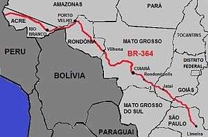
BR-364
| |
|---|---|
| Marechal Rondon Highway | |
 | |
|
Section of the highway in Acre | |
| Route information | |
| Length: | 4,324.6 km (2,687.2 mi) |
| Existed: | 1960 – present |
| Major junctions | |
| Southeast end: | Limeira, São Paulo |
|
São Paulo: BR-456, BR-265 Minas Gerais: BR-497, BR-365 Goiás: BR-483, BR-060, BR-359 Mato Grosso: BR-163, BR-070, BR-174 Mato Grosso/Rondônia: BR-153 Rondônia: BR-435, BR-429, BR-421, BR-319, BR-425 Acre: BR-317 | |
| West end: | Mâncio Lima, Acre |
| Highway system | |
|
Highways in Brazil | |

BR-364 is an inter-state highway in Brazil connecting the southeast state of São Paulo to the western state of Acre. The highway was opened in the 1960s and paved in the 1980s. It has brought economic development and population growth in the Amazon basin states of Rondônia and Acre. It has also caused massive environmental damage and socio-economic impacts.
Route
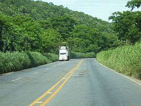
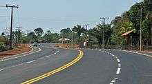
BR-364 starts in Limeira in São Paulo state and runs northwest through Minas Gerais, Goiás, Mato Grosso, Rondônia and Acre to Rodrigues Alves, then on to Mâncio Lima on the frontier with Peru. It passes through the cities of Cuiabá (Mato Grosso), Porto Velho (Rondônia) and Rio Branco (Acre).[1] The all-weather highway gives the people of the remote Amazon states of Rondônia and Acre access to goods, services and people from the well-populated regions around São Paulo.[2] The highway runs through the Cerrado, Pantanal and Amazon rainforest biomes, and through sugar cane, soy bean and cotton farming areas. In some areas it is poorly maintained. At the border between Rondônia and Acre a ferry is used to cross the Madeira River, which can cause major traffic delays.[3]
History
Early years
Construction was initiated by Juscelino Kubitschek in 1961 for the transport of cassiterite for use in Brazilian industry, and to open the west for population.[3] BR-364 and the BR-230 Trans-Amazonian Highway were intended to integrate, protect and bring people to the "undeveloped, unproductive and empty" Amazon. The BR-364, BR-230 and BR-163 highways did provide access to the Amazon basin but also caused destruction of the environment.[4] BR-364 was the first main road between the Amazon basin and the rest of Brazil, and was intended to provide an access route for developing infrastructure between Cuiabá and Porto Velho. In practice it connected roads from Sao Paulo to the west of Acre.[1]
In the 1960s about 3,000 people per year had moved to Rondônia. The 1,500 kilometres (930 mi) BR-364 highway from Cuiabá to Porto Velho made the state accessible for settlement in 1968.[5] The road was still unpaved and could not be used in the rainy season.[6] However, LANDSAT photographs in June 1976 showed deforested areas along and perpendicular to BR-364 in Rondonia.[7] 1972–73 imagery of Rondonia showed no more than small and scattered areas of forest disturbance. Comparison to 1981 imagery showed accelerating clearance, expected to increase further when the highway was paved.[8] Based on satellite images, as of 1982 it was estimated that 11,400 square kilometres (4,400 sq mi) of forest had been cleared in Rondonia along the highway.[9]
An inspection of the section between Porto Velho and Pimenta Bueno in September 1982 found forest clearing roads at right angles to the highway about 4 kilometres (2.5 mi) apart, some more than 80 kilometres (50 mi) long, which had showed as "linear forest-disturbance features" on satellite photographs. In a government-planned colonisation project the immigrant farmer would be sold a 100 hectares (250 acres) lot for agriculture or pasture with about 400 metres (1,300 ft) of road frontage. Narrow strips of primary forest were left at the back of the lots. The farmer would start clearing at the access road, then clear further back to reach soil that had not yet been depleted of nutrients.[10] As with slash-and-burn agriculture in other tropical areas, the farmers in the BR-364 zone could only obtain crops for 3–5 years before the soil was exhausted and they had to move on.[11]
Polonoroeste
Half a million settlers had moved west on BR-364 by 1980 including ranchers, wildcat miners, land speculators and prostitutes. The situation was out of control.[12] The Northwest Brazil Integrated Development Program (Polonoroeste) was created by decree in May 1981 with a budget for 1981–85 of US$1.5 billion. Under this program BR-364 was to be paved, the road network in the region expanded, colonisation schemes created or expanded, land titles regularised and economic activities encouraged. The World Bank provided a third of the funding, and by 1981 had approved loans of US$240 million for road construction alone. US$67 million was allocated to environment protection.[6] The Polonoroeste project opened Rondônia to a greater flood of migrants from the state of Paraná.[13]
Paving of BR-364 through Rondonia was completed in 1984 and the number of migrants rose to about 160,000 per year.[14] The result was a surge of deforestation that had a large impact on the indigenous people.[13] Satellite images show the fish-bone pattern of deforestation along unpaved roads leading from the highway.[1] The government could not handle the flood of migrants with formal settlement schemes, and responded with a "Rapid Settlement" program that recognised informal settlements outside the government-controlled areas.[15]
Deforestation in Rondônia rose to an average of 2,340 square kilometres (900 sq mi) in 1978–88, or about 1.11% of the state's area.[14] With support from the state government in the form of rural credit programs the farmed area in Rondonia increased from 1,600,000 hectares (4,000,000 acres) in 1970 to about 8,900,000 hectares (22,000,000 acres) in 1995. 46% of agricultural output was from small farms of 10 to 100 hectares (25 to 247 acres).[2] Deforestation reached a second peak in 2004.[1]
Acre extension
The World Bank loan had been contingent on measures being taken to protect the environment and indigenous people, but it was clear by late 1984 that these rules were being ignored and protected areas were being deforested by ranchers and small farmers. In October 1984 a group of 32 NGO's from the US, Brazil and other countries wrote to the World Bank asking for immediate action, but were brushed off with a bland reply. Leading US environmental groups took their case to the US Congress in late 1984, where they gained support from key senators and representatives.[16] The World Bank refused a request from the government of Brazil to fund paving the highway into Acre, and the request was passed to the Inter-American Development Bank (IDB).[17] In 1987 the World Bank President, Barber Conable, called the road project "a sobering example of an environmentally sound effort which went wrong."[13]
The IDB, which was mainly funded by the United States, was asked to cover half the cost of the Acre extension.[14] The IDB Executive Director abstained from voting on the project. Eventually the IDB agreed to fund paving the Acre section, but only in conjunction with a program to protect the environment and indigenous people (PMACI).[17] The rubber tapper leader Chico Mendes was concerned that the paved road would cause a rise of migrants into Acre. The Environmental Defense Fund and the National Wildlife Federation arranged for Mendes to come to the US to warn IDB officials of the ecological risks, and supporters of Mendes presented the issue to the Foreign Operation Appropriation Sub-Committee of the US Senate.[14] In August 1987 the IDB suspended funding due to noncompliance with the PMACI.[17]
The slow-down in road construction in Acre made Mendes a target for those who would benefit.[14] On his return from the US Mendes was branded as an obstructionist, a false leader, opposed to progress in Acre.[18] In fact, Mendes had not been opposed to the road, but had insisted that the environmental protection provisions be met.[19] Mendes was murdered in late 1988, raising awareness of the issues internationally and in Brazil.[20] In July 1989 funds were at last released by the IDB under an new agreement.[17] The section from Porto Velho to Acre was paved in the early 1990s.[2] After this the IDB and the World Bank would stop funding large-scale South American road projects for many years.[21] Settlers had less impact in Acre, partly because the state had a larger base of farmers before the highway came through. There was a marked shift of farming activity away from the west of the state to Rio Branco in the east.[2]
-

Eastern Acre in 2000. BR-364 running from the right to Rio Branco (left), with fish bone deforestation pattern
-
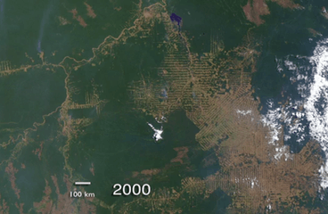
Rondônia in 2000. BR-364 runs from the lower right up to Porto Velho (top centre, beside blue Samuel Dam), then southeast along the Madeira River.
-
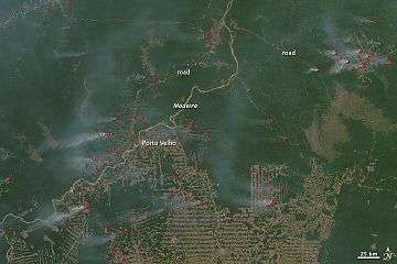
Fires near Porto Velho in 2010
Later improvements

Sustainable production is possible. Pastures of Urochloa brizantha (palisade grass) seem to be reasonably productive on moderately fertile ultisols near Rio Branco, but may require fertilisation on poorer soils and may prove vulnerable to insects.[22] In 1993 and 1994 at least a quarter of the cattle ranches along BR-364 and its side roads were practising some sort of improved pasture management.[23] The 10,247 hectares (25,320 acres) Fazenda Bonal at km 70 of the BR 364 section between Rio Branco and Porto Velho was originally intended as a rubber plantation, and still has 900 hectares (2,200 acres) of rubber tree, but as of 1995 was increasingly being used for peach palm plantation to produce bottled heart of palm. Through use of Pueraria as a ground cover the need for fertiliser is kept low. Most of the original forest is intact.[24]
The state of Acre has created a REDD+ initiative, initially to be based on 7–8 areas with high risk of deforestation but later made state-wide. In 2012 ISA-Carbono was considered the most advanced program of this type in the world.[25] The Acre state government began to take low carbon development actions in 2008.[25] These included planned (but delayed) grants of property titles and a ban or partial ban on burning.[26] Farmers who agree to participate in the Smallholder Properties Program are given bonuses for stopping deforestation, assistance in soil enrichment, fish or chicken farming or Açaí palm planting, and other incentives.[27]
A 2010 study looked in detail at the BR-364 priority assistance zone (ZAP), one of the original high risk areas, which covered 5 kilometres (3.1 mi) along both sides of BR-364 in the municipalities of Manoel Urbano and Feijó.[25] In 2010 only 4% of this area was deforested.[25] BR-364 was unpaved and therefore impassible for the eight rainy months of the year. Paving was completed in 2011.[27] The study found that there had been improvements, but deforestation had not been completely halted. Bonus payments were late or did not arrive, and technical support for farming without fire was not consistent.[28] Another issue is that REDD+ funding is uncertain, with immature structures for carbon emissions trading.[29]
In April 2015 the National Council of Privatisation approved the model for a 30-year toll concession on a 437 kilometres (272 mi) stretch of highway consisting of BR-365 from the western boundary of Uberlândia, Minas Gerais, to BR-364 on the Minas Gerais / Goiás border, then BR-364 from there to the junction with BR-060 near Jataí, Goiás. The concession holder would be responsible for maintenance of the roads.[30]
-

Entrance to São Carlos, São Paulo
-

Bridge over the Machado River at Ji-Paraná, Rondônia
-

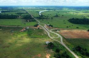
Divided section near Porto Velho, Rondônia
-

Ferry across the Madeira River from Rondônia to Acre
Notes
- 1 2 3 4 Cooper & Hunefeldt 2013, p. 98.
- 1 2 3 4 Vosti, Witcover & Carpentier 2002, p. 18.
- 1 2 BR 364 – O mundo em que vivo.
- ↑ Cooper & Hunefeldt 2013, p. 99.
- ↑ Barbosa 2000, p. 35.
- 1 2 Barbosa 2000, p. 56.
- ↑ Trabalka & Reichle 2013, p. 247.
- ↑ Trabalka & Reichle 2013, p. 227.
- ↑ Trabalka & Reichle 2013, p. 252.
- ↑ Trabalka & Reichle 2013, p. 226.
- ↑ Hobbs 2016, p. 485.
- ↑ Reid 2014, p. 206.
- 1 2 3 Fearnside 2005, p. 6.
- 1 2 3 4 5 Barbosa 2000, p. 117.
- ↑ Barbosa 2000, p. 56–57.
- ↑ Schmink & Wood 2013, p. 114.
- 1 2 3 4 Schmink & Wood 2013, p. 115.
- ↑ Rodrigues 2009, PT152.
- ↑ Rodrigues 2009, PT128.
- ↑ Schmink & Wood 2013, p. 117.
- ↑ Dijck 2013, p. 59.
- ↑ Smith 1995, p. 176–177.
- ↑ Smith 1995, p. 178.
- ↑ Smith 1995, p. 158.
- 1 2 3 4 Sills et al. 2014, p. 35.
- ↑ Sills et al. 2014, p. 40.
- 1 2 Sills et al. 2014, p. 41.
- ↑ Sills et al. 2014, p. 49.
- ↑ Sills et al. 2014, p. 48.
- ↑ Brazil's Infrastructure 2016, PT30.
| Wikimedia Commons has media related to BR-364. |
Sources
- Barbosa, Luiz C. (2000), The Brazilian Amazon Rainforest: Global Ecopolitics, Development, and Democracy, University Press of America, ISBN 978-0-7618-1522-8, retrieved 2016-06-19
- "BR 364", O mundo em que vivo (in Portuguese), 21 August 2011, retrieved 2016-06-19
- Brazil's Infrastructure, MPOG, 2016-06-13, GGKEY:WXX69UUNKS2, retrieved 2016-06-19
- Cooper, James M.; Hunefeldt, Christine (2013), Amazonia: Environment and the Law in Amazonia : a Plurilateral Encounter, Sussex Academic Press, ISBN 978-1-84519-500-7, retrieved 2016-06-19
- Dijck, Pitou van (2013-03-07), The Impact of the IIRSA Road Infrastructure Programme on Amazonia, Routledge, ISBN 978-0-415-53108-5, retrieved 2016-06-19
- Fearnside, Philip M. (January 2005), "Brazil's Samuel Dam: lessons for hydroelectric development policy and the environment in Amazonia", Environ Manage, National Institute for Research in the Amazon, 35 (1): 6, retrieved 2016-05-15
- Hobbs, Joseph (2016-01-30), Fundamentals of World Regional Geography, Cengage Learning, ISBN 978-1-305-85495-6, retrieved 2016-06-19
- Reid, Michael (2014-05-27), Brazil: The Troubled Rise of a Global Power, Yale University Press, ISBN 978-0-300-16560-9, retrieved 2016-06-19
- Rodrigues, Gomercindo (2009-03-06), Walking the Forest with Chico Mendes: Struggle for Justice in the Amazon, University of Texas Press, ISBN 978-0-292-77454-4, retrieved 2016-06-20
- Schmink, Marianne; Wood, Charles H. (2013-08-13), Contested Frontiers in Amazonia, Columbia University Press, ISBN 978-0-231-51388-3, retrieved 2016-06-20
- Sills, Erin O; Atmadja, Stibniati S; Sassi, Claudio de; Duchelle, Amy E; Kweka,, Demetrius; Resosudarmo, Ida Aju Pradnja; Sunderlin, William D (2014-12-24), REDD+ on the ground: A case book of subnational initiatives across the globe, CIFOR, ISBN 978-602-1504-55-0, retrieved 2016-06-19
- Smith, Nigel J. H. (1995), Amazonia, United Nations University Press, ISBN 978-92-808-0906-0, retrieved 2016-06-19
- Trabalka, John R.; Reichle, David E. (2013-03-09), The Changing Carbon Cycle: A Global Analysis, Springer Science & Business Media, ISBN 978-1-4757-1915-4, retrieved 2016-06-19
- Vosti, Stephen A.; Witcover, Julie; Carpentier, Chantal Line (2002-01-01), Agricultural Intensification by Smallholders in the Western Brazilian Amazon: From Deforestation to Sustainable Land Use, Intl Food Policy Res Inst, ISBN 978-0-89629-132-4, retrieved 2016-06-20
| Rodovias radiais | |
|---|---|
| Rodovias longitudinais | |
| Rodovias transversais |
|
| Rodovias diagonais | |
| Rodovias de ligação |
|