Břeclav
| Břeclav | |||
| Town | |||
.JPG) Modern St. Wenceslas Church | |||
|
|||
| Country | Czech Republic | ||
|---|---|---|---|
| Region | Moravia-South Moravian | ||
| District | Břeclav | ||
| Commune | Břeclav | ||
| Elevation | 158 m (518 ft) | ||
| Coordinates | CZ 48°45′32.29″N 16°52′55.31″E / 48.7589694°N 16.8820306°ECoordinates: CZ 48°45′32.29″N 16°52′55.31″E / 48.7589694°N 16.8820306°E | ||
| Area | 77.11 km2 (29.77 sq mi) | ||
| Population | 24,949 | ||
| Density | 324/km2 (839/sq mi) | ||
| Founded | 11th century | ||
| Mayor | Pavel Dominik | ||
| Timezone | CET (UTC+1) | ||
| - summer (DST) | CEST (UTC+2) | ||
| Postal code | 690 02 | ||
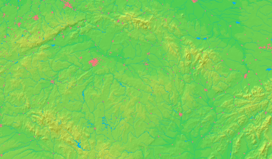  Location in the Czech Republic
| |||
| Wikimedia Commons: Břeclav | |||
| Statistics: statnisprava.cz | |||
| Website: www.breclav.eu | |||


Břeclav (Czech pronunciation: [ˈbr̝ɛtslaf]; German: Lundenburg; Hungarian: Leventevár) is a town in the Moravia, South Moravian Region, Czech Republic, approximately 55 km southeast of Brno. It is located at the border with Lower Austria on the Dyje River. The nearest town on Austrian territory is Hohenau an der March. Břeclav also lies 10 km northwest of the Slovak border at Kúty and 100 km north of the Austrian capital city Vienna.
History
Pohansko
In the area of the town several localities have been discovered which were settled in prehistory. Of these the most important one is called Pohansko (meaning "a paganish (place)") southeast of the town, that became a significant grad in Great Moravian times. In the 10th century it was abandoned; today there is an archaeological site with an exhibition.
Břeclav Castle
In the 11th century a border castle was established by Duke Bretislaus I which took his name (in Czech Břetislav → Břeclav). The castle served as one of the ducal administrative centres in medieval Moravia, later becoming a manor house. The Zierotins rebuilt it in Renaissance style. In 1638 the House of Liechtenstein gained it, but the family did not reside there and in the early 19th century they rebuilt it to artificial ruins as a part of the Lednice-Valtice cultural-natural complex.
Town
There was originally a market town by the castle, which was destroyed in the 15th century and then refounded closer to the castle (which is in the area of today's town centre); the original spot has been called Old Břeclav (Stará Břeclav) since that time. Both the (new) market town and village of Old Břeclav were badly damaged in battles during the 17th century.
The opening of a railway to Vienna and Brno in 1839 (and subsequent extensions to a junction) represented an important event, that brought industrialisation and population growth: from 2,952 inhabitants (of Břeclav and Old Břeclav together) in 1834 to 13,689 in 1930. As a consequence, Břeclav obtained town status (1872), becoming the seat of the judicial (1850) and political (1949) district. In 1919 three original municipalities merged (Břeclav, Old Břeclav and Jewish Municipality of Břeclav); in 1974 another two - Poštorná and Charvátská Nová Ves (both were parts of Lower Austria until 1920) - were joined. In 1938-1945 Břeclav was a part of Nazi Germany, although the town's population was mostly Czech-speaking. Local Jews (4.3% in 1930) and Germans (11.6%) were expelled both during and after World War II.
Transport
Břeclav railway station is an important hub in the railroad network (the first junction in Austria-Hungary). It is located at the intersection of the routes to and from Brno - Prague, Ostrava - Kraków/Katowice (Poland), Kúty - Bratislava (Slovakia) and Hohenau an der March - Vienna (Austria). In addition, a local railway to Znojmo also branches out from the station.
The D2 motorway, linking Brno with the Slovak border, and further with Bratislava, passes close to the town.
Geography and Climate
Břeclav lies in a very flat river valley which is the warmest part of Moravia and whole Czech Republic. There is wild thick riparian forest composed of broad leaved trees in the southern corner of town's surroundings, ending in the southernmost part of Moravia, where confluence of rivers Thaya and Moravia can be found. Average year temperature is 9.6 °C (49.3 °F) with average temperature in July reaching 19.5 °C (67.1 °F) and average temperature in January decreasing to −1.4 °C (29.5 °F). Local climate is warm, with cool, dry, and short winter season starting in first weeks of December and ending in the second half of February. Warm and sunny spring comes in the end of February continuing to May when wetter and moderately hot summer starts, being itself replaced by drier and cooler autumn during end of September.
| Climate data for Břeclav | |||||||||||||
|---|---|---|---|---|---|---|---|---|---|---|---|---|---|
| Month | Jan | Feb | Mar | Apr | May | Jun | Jul | Aug | Sep | Oct | Nov | Dec | Year |
| Average high °C (°F) | 1.5 (34.7) |
4.2 (39.6) |
9.4 (48.9) |
15.4 (59.7) |
20.5 (68.9) |
23.8 (74.8) |
25.7 (78.3) |
25.2 (77.4) |
20.9 (69.6) |
14.9 (58.8) |
7.9 (46.2) |
3.3 (37.9) |
14.4 (57.9) |
| Daily mean °C (°F) | −1.4 (29.5) |
0.7 (33.3) |
4.7 (40.5) |
9.8 (49.6) |
14.6 (58.3) |
18.0 (64.4) |
19.5 (67.1) |
19.1 (66.4) |
15.2 (59.4) |
9.9 (49.8) |
4.7 (40.5) |
0.6 (33.1) |
9.6 (49.3) |
| Average low °C (°F) | −4.3 (24.3) |
−2.7 (27.1) |
0.1 (32.2) |
4.3 (39.7) |
8.8 (47.8) |
12.2 (54) |
13.4 (56.1) |
13.1 (55.6) |
9.6 (49.3) |
5.0 (41) |
1.5 (34.7) |
−2.0 (28.4) |
4.9 (40.8) |
| Average precipitation mm (inches) | 34 (1.34) |
33 (1.3) |
37 (1.46) |
45 (1.77) |
66 (2.6) |
83 (3.27) |
83 (3.27) |
74 (2.91) |
49 (1.93) |
41 (1.61) |
48 (1.89) |
41 (1.61) |
634 (24.96) |
| Source: climate-data.org[1] | |||||||||||||
Sights
- A Renaissance castle from the 16th century with an arcade on the courtyard; during the first half of the 19th century it was completely rebuilt as Neo-Gothic artificial ruins
- St. Wenceslas parish church in the Masaryk Square - a contemporary architecture from 1992-1995 on the spot of a Baroque one destroyed in World War II
- Synagogue - Neo-Romanesque building from 1868 with Neo-Moorish elements inside; nowadays it serves as a part of the town museum
- St. Mary parish church in Poštorná - a unique Neo-Gothic construction with a cupola, built in 1895-1898 with use of special bricks from local factory
- Jewish Cemetery with tombstones from the 18th century and a Neo-Gothic morgue from 1892
- Resurrection Chapel from 1875 in an area of the former cemetery in the Sovadina street
Close to the train station there are:
- St. Rochus Chapel (in front of the Gymnasium) - built in 1892 in memory of a cholera epidemic
- St. Cyril and Methodius Chapel (in a park in front of the station) - built in 1853-1856 in memory of a recovery of Prince of Liechtenstein, local lord; it served as a place of worship for local Catholic parish before the St. Wenceslas Church was built
In the surroundings:
- Pohansko - an archaeological site from Great-Moravian times
- The Lednice-Valtice Area - a UNESCO World Heritage Site since 1996
Gallery
 River Dyje in the town centre
 Břeclav Castle
 Main post office
 (Former) synagogue
 Our Lady Church in Poštorná
 St. Cyril and Methodius Chapel
 St. Rochus Chapel
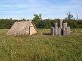 From the archaeological site of Pohansko
International relations
Twin towns — Sister cities
Břeclav is twinned with:
-
 Zwentendorf, Austria
 -
 Trnava, Slovakia
 - Brezová pod Bradlom, Slovakia
-
 Andrychów, Poland
 -
 Šentjernej, Slovenia
 -
 Nový Bor, Czech Republic
See also
References
- ↑ "Climate: Hohenau an der March". Climate-Data.org. Retrieved 10 December 2013.
External links
| Wikimedia Commons has media related to Břeclav. |