Børgefjell National Park
| Børgefjell National Park | |
|---|---|
|
IUCN category II (national park) | |
|
| |
| Location | Nordland and Nord-Trøndelag, Norway |
| Nearest city | Mosjøen (north), Grong (south) |
| Coordinates | 65°11′N 13°54′E / 65.183°N 13.900°ECoordinates: 65°11′N 13°54′E / 65.183°N 13.900°E |
| Area | 1,447 km2 (558.7 sq mi) |
| Established | 1963 |
| Governing body | Directorate for Nature Management |
Børgefjell National Park (Norwegian: Børgefjell nasjonalpark, Southern Sami: Byrkije vaarjelimmiedajve) is an undeveloped national park in Norway, straddling the border between Nord-Trøndelag and Nordland county, with a border to Sweden. The park is for the most part a reservation, with few trails or other facilities for visitors. Visitors can hike for extended periods without seeing another person. The 1,447-square-kilometre (559 sq mi) park was originally established in 1963, and it was enlarged in 1973 and 2003.
Landscape
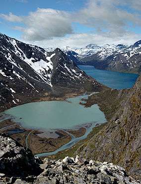
The landscape varies from dramatic peaks of dark granite and grey mountains with little vegetations, to fertile mountain slopes and marshes. The highest mountain peaks are in the west where the bedrock is primarily dark Børgefjell granite, which gives the landscape its desolate appearance. This is where you will find the highest mountain in the park, Kvigtinden, towering 1,699 metres (5,574 ft) above sea level. The 1,513-metre (4,964 ft) tall Jetnamsklumpen is the tallest mountain in Nord-Trøndelag, and it is also located in the park. Other places, such as in the Rainesfjellet area, you will find rough stone screes without vegetation. Sub-glacial moraines cover much of the landscape. There are many lakes, ponds, and raging rivers.[1]
Fauna
Børgefjell is best known as the home to the rare Arctic fox, although in terms of numbers the wolverine is the most common of the large predators. Both lynx and bear are also found here. The most common small predators are the red fox, the snow weasel, the marten, and the stoat. It is also possible to catch the occasional glimpse of an otter.
All of Børgefjell is used for domestic reindeer grazing. The western, eastern, and southern parts of the national park are mainly used as grazing areas in the summer, while the northern areas are used for grazing all year round. Furthest east there are also reindeer coming in from Sweden.[1]
History
The Sami people controlled the land in Børgefjell right up until the beginning of the twentieth century. They have kept reindeer in the area for at least 500 years. Sami cultural monuments in the form of settlements and hunting stations can be found both inside the national park and in the border areas around it. The first farms in the area appeared at the end of the 1700s and beginning of the 1800s, and Norwegian settlement increased from then onwards. The first farms were established when there was a shortage of land elsewhere.[1]
Name
The first element seems to be the Old Norse word byrgi which means "fort" or "entrenchment". (There might have been some kind of fort here once, possibly to claim tax from the southern Sami people, and also to protect the border from the Swedes.) The last element is fjell which means "fell" or "mountain".
References
- 1 2 3 Directorate for Nature Management. "Børgefjell: A sanctuary for the arctic fox" (PDF). Retrieved 2011-09-12.