Azufral
| Azufral | |
|---|---|
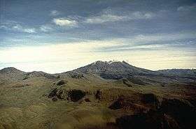 Azufral in 1989 | |
| Highest point | |
| Elevation | 4,070 m (13,350 ft) [1] |
| Coordinates | 1°05′N 77°41′W / 1.083°N 77.683°WCoordinates: 1°05′N 77°41′W / 1.083°N 77.683°W [1] |
| Geography | |
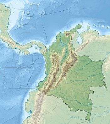 Azufral Location in SW Colombia | |
| Location | Nariño, Colombia |
| Parent range | Cordillera Central, Andes |
| Geology | |
| Age of rock | Holocene |
| Mountain type | Stratovolcano |
| Volcanic arc/belt | Northern Volcanic Zone, Andean Volcanic Belt |
| Last eruption | 930 BC(?)[1] |
Azufral is a volcano located in the department of Nariño in southern Colombia, 12 km (7 mi) west of the town of Túquerres. Its name derives from the Spanish word for sulfur, azufre. The volcano is considered semi-dormant but there are numerous fumaroles in the summit crater. The summit of the volcano has an altitude of 4,070 metres[1] and the north-western side of the crater contains a crescent-shaped lake named lago Verde (English: Green Lake) at 3,970 m (13,025 ft). The lake is 1,100 m (3,600 ft) long and 600 metres wide[2] and its bright green color is a result of the sulfur and iron-based deposits in the crater. There are also two other much smaller lakes in the crater, Laguna Negra (English: Black Lake) and Laguna Cristal (English: Crystal Lake).
The volcano lies within a nature reserve, the Reserva Natural del Azufral, created in 1990.[2] The reserve covers an area of 5,800 hectares (58 km2) and is free of charge to enter. As Azufral is semi-dormant there are no restrictions on ascending the volcano and visiting the Laguna Verde: there is a road that climbs to within 1.5 kilometers (1 mi) from the summit, and the remaining distance can be covered on foot via a trail.
See also
References
- 1 2 3 4 "Azufral". Global Volcanism Program. Smithsonian Institution. Retrieved January 19, 2007.
- 1 2 "El Azufral, seis años como reserva", El Tiempo, June 12, 1996 (in Spanish). Retrieved May 2, 2011.
Treasures of Colombia | |||||||||||||||||||||||||||||||||||||||||||||||||||||
|---|---|---|---|---|---|---|---|---|---|---|---|---|---|---|---|---|---|---|---|---|---|---|---|---|---|---|---|---|---|---|---|---|---|---|---|---|---|---|---|---|---|---|---|---|---|---|---|---|---|---|---|---|---|
Archaeological sites · Colombia magia salvaje · National monuments · National parks · World Heritage sites | |||||||||||||||||||||||||||||||||||||||||||||||||||||
| |||||||||||||||||||||||||||||||||||||||||||||||||||||
| |||||||||||||||||||||||||||||||||||||||||||||||||||||
| |||||||||||||||||||||||||||||||||||||||||||||||||||||
Source: Wills, Fernando et al. 2001. Nuestro patrimonio - 100 tesoros de Colombia - Our heritage - 100 treasures of Colombia, 1-311. El Tiempo. | |||||||||||||||||||||||||||||||||||||||||||||||||||||