Aztec Motel
|
Aztec Auto Court | |
|
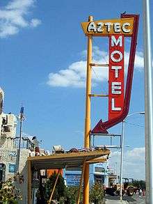
Aztec Motel in 2010 | |
| Location | 3821 Central Avenue NE, Albuquerque, New Mexico |
|---|---|
| Built | 1932 |
| Demolished | 2011 |
| NRHP Reference # | 93001217[1] |
| Added to NRHP | November 22, 1993 |

The Aztec Motel, also known as the Aztec Auto Court or Aztec Lodge, was a historic motel located on former U.S. Route 66 in the Upper Nob Hill neighborhood of Albuquerque, New Mexico, United States. It was demolished in 2011 despite being the oldest continuously-operating Route 66 motel in New Mexico[2] and "one of the five most important motels left" in Albuquerque.[3]
The motel was built in 1932 as the first of what would eventually be dozens of auto courts lining Central Avenue.[4] It was listed on the New Mexico State Register of Cultural Properties[5] and the National Register of Historic Places in 1993.[1] The building was well known locally for its exterior decorations, which consisted of hundreds of found objects assembled in the 1990s by a resident of the motel. The work was described in the Albuquerque Journal as a "beloved local folk art installation".[2]
The Aztec Motel was razed in early June 2011. The motel's owner cited its deteriorating condition and high maintenance costs as reasons for the demolition, estimating the building would cost $1 million to renovate.[3] The motel's neon sign was preserved and will become part of any future development on the site.[2]
See also
References
| Wikimedia Commons has media related to Aztec Motel. |
- 1 2 National Park Service (2009-03-13). "National Register Information System". National Register of Historic Places. National Park Service.
- 1 2 3 Linthicum, Leslie (June 16, 2011). "History Takes a Lick on Route 66". Albuquerque Journal. NM. p. A1.
- 1 2 Tomlin, Alex (June 10, 2011). "Historic Route 66 motel demolished". KRQE News. NM. Retrieved 16 August 2011.
- ↑ "Aztec Auto Court". US National Park Service.
- ↑ "Properties by County" (PDF). New Mexico Department of Cultural Affairs. Retrieved 29 April 2011.
Coordinates: 35°4′46.5″N 106°36′4.5″W / 35.079583°N 106.601250°W