Ayles Ice Shelf
Coordinates: 83°1.5′N 77°33.5′W / 83.0250°N 77.5583°W
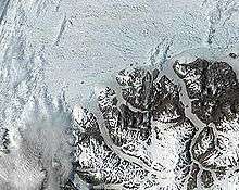

The Ayles Ice Shelf was one of six major ice shelves in Canada, all on the north coast of Ellesmere Island, Nunavut. The ice shelf broke off from the coast on August 13, 2005, forming a giant ice island 37 metres (121 ft) thick and measuring around 14 km (8.7 mi) by 5 km (3.1 mi) in size (approximately 66 km² or 25.5 mi (41.0 km)² in area or 2.6 km³ in volume). The oldest ice in the ice shelf is believed to be over 3,000 years old. The ice shelf was at (83°1.5′N 77°33.5′W / 83.0250°N 77.5583°W), approximately 800 km (500 mi) south of the North Pole.
The Ayles Ice Shelf, like the nearby Mount Ayles, was named for the Arctic explorer Adam Ayles, who served under George Nares as the Petty Officer of HMS Alert in the British Arctic Expedition.[1] A 1986 survey of Canadian ice shelves found that 48 square km (3.3 cubic km) of ice calved from the Milne and Ayles ice shelves between 1959 and 1974.[2]
Ayles Ice Island
On August 13, 2005, the entire shelf broke clear from the coast of Ellesmere, forming a new ice island. It is believed to be the largest shelf breakup of its kind in Canada in over 30 years.[3] The event was registered on seismometers in northern Canada, and it was also verified via satellite imagery.
The breakup was noticed by the Canadian Ice Service at the time that it occurred, but it took a further 16 months to fully reconstruct the breakup sequence from past satellite images captured by MODIS, to determine the climatic conditions during the event, and for the event to garner public attention. The event, which some have linked to global warming, is similar to the 2002 breakup of the Larsen B Ice Shelf in Antarctica.[4][5][6]
The speed of the breakup is also remarkable; it took less than an hour. Canada has lost approximately 90% of its ice shelves in the last hundred years.[7]
Within days of the breakup, the former shelf had drifted over 50 km (31 mi) from Ellesmere Island before freezing into the sea ice for the winter. It was estimated in May, 2007 to be between 138 feet (42 m) and 148 feet (45 m) thick, on average.[8]
The freed segment of the ice shelf, known as Ayles Ice Island, drifted southwesterly for two years, and in January 2007 accelerated into the open Arctic Ocean, causing concern for oil rig operators in the Beaufort Sea north of Prudhoe Bay. In August 2007, however, the island became wedged into the Sverdrup Inlet of the Queen Elizabeth Islands. Although scientists initially thought it was likely to remain there for some time, possibly permanently,[9] it soon afterwards broke into two parts and resumed movement.[8]
There is concern that the ice islands may become a hazard for ships and oil platforms.[10]
While the formation of the Ayles Ice Island received widespread attention at the time due to the availability of satellite imagery and the ability of news media and scientists to visit the island, it was by no means unprecedented. On August 14, 1946, a U.S. Air Force patrol plane flying 300 miles (480 km) north of Port Barrow, Alaska spotted an ice island, dubbed T-1, which was 15 miles (24 km) wide and 18 miles (29 km) across. It was estimated to be from 240 to 1,600 feet (490 m) thick, with sides that rose from 30 to 200 feet (61 m) above the sea surface - much larger than the Ayles Ice Island. Over the following three years, it travelled around 1,500 miles (2,400 km) along the Beaufort Eddy, a slow-moving ocean current that flows eastward across the North Pole, then back west along the coast. In 1950, the U.S. Air Force 58th Reconnaissance Squadron was ordered to find T-1, and any other ice islands in the Arctic. In July, 1950, T-2 was found, a roughly rectangular ice island estimated to be 20 miles (32 km) by 20 miles (32 km) by dimension. In 1947, a joint U.S.-Canadian expedition had noted and photographed a fresh water sea formation in the sea off Ellesmere Island. From a photographic examination of its ridges, T-2 was discovered to be the same ice island spotted off Ellesmere Island in 1947. Later in July 1950, the U.S. Air Force found T-3, a kidney-shaped island, nine by four and a half miles. This was later occupied for brief periods in the early and mid-1950s. In August 1951, T-1 was relocated, nestled along the coast of Ellesmere Island. It is not known how long prior T-1, T-2, and T-3 had been formed, but it is believed they had calved from ice shelves on northern Ellesmere Island.[11] There are an estimated 80 ice islands in Canada's High Arctic, most of them part of the pack ice that covers the region.
Between August 1961 and April 1962, almost 600 square kilometres of ice broke away from the Ward Hunt Ice Shelf.[12] This event was attributed to tidal and seismic events.
References
- ↑ Wairarapa Times-Age newspaper article biography of Adam Ayles
- ↑ Jeffries, Martin O. Ice Island Calvings and Ice Shelf Changes, Milne Ice Shelf and Ayles Ice Shelf, Ellesmere Island, N.W.T.. Arctic 39 (1) (March 1986).
- ↑ Giant ice island breaks off Arctic shelf, Guardian Unlimited
- ↑ Richard A. Lovett (29 December 2006). "Giant Ice Shelf Breaks Off in Canadian Arctic". National Geographic. Retrieved 30 December 2011.
- ↑ "Ancient ice shelf breaks free in Canadian Arctic". MSNBC. 29 December 2006. Retrieved 30 December 2011.
- ↑ Jeff Schmaltz (6 January 2007). "Ayles Ice Shelf, Ellesmere Island". Earth Observatory, NASA Goddard Space Flight Center. Retrieved 30 December 2011.
- ↑ Arctic Ice Shelf Broke Off Canadian Island, New York Times
- 1 2 "Arctic ice island breaks in half". BBC News Online. 1 October 2007. Archived from the original on 11 October 2007. Retrieved 2007-10-02.
- ↑ "Vast ice island trapped in Arctic". BBC News Online. August 31, 2007. Archived from the original on 17 October 2007. Retrieved 2007-09-02.
- ↑ Arctic ice shelf collapse poses risk: expert, CBC news
- ↑ "The Mysterious Floating Islands of the Arctic", Reader's Digest January 1952
- ↑ G. Hattersley-Smith, 1963 "The Ward Hunt Ice Shelf: recent changes of the ice front" Journal of Glaciology 4:415-424.
External links
| Wikinews has related news: Ice shelf breaks free in Canadian arctic |
- 16-image slideshow of satellite and radar images showing the breakup (CBC News, requires Adobe Flash).
- Ayles Ice Shelf breakup images and media resources by Dr. Luke Copland, University of Ottawa
- Ayles Ice Shelf breakup background information by the Canadian Ice Service
- Arctic ice shelf collapse poses risk: expert, CBC news, Thursday, December 28, 2006, 6:39 PM ET
- Huge ice shelf breaks free in Canada's far north by Jeffrey Jones, Reuters, 29 Dec 2006 21:22:06 GMT
- Huge Arctic ice break discovered, BBC news, Friday, 29 December 2006, 22:52 GMT
- Giant Ice Shelf Breaks Off in Canadian Arctic by Richard A. Lovett, National Geographic News, December 29, 2006
- Ice-shelf collapse, climate change, and habitat loss in the Canadian high Arctic F. W. Vincent, J. A. E. Gibson & M. O. Jeffries. Polar Record 37 (201): 133-142 (2001).
- Science team lands on Ice Island, BBC News, Tuesday 22 May 2007