Vardar
| Vardar (Вардар), Axios (Αξιός) | |
|---|---|
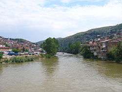 Vardar in Veles | |
| Country | Republic of Macedonia, Greece |
| Basin | |
| Main source | Vrutok, near Gostivar |
| River mouth |
Aegean Sea, near Thessaloniki 40°30′27″N 22°43′3″E / 40.50750°N 22.71750°ECoordinates: 40°30′27″N 22°43′3″E / 40.50750°N 22.71750°E |
| Physical characteristics | |
| Length | 388 km (241 mi) |
The Vardar or Axios (Macedonian: ![]() Вардар ; Greek: Αξιός Axiós or Βαρδάρης Vardárīs) is the longest and major river in the Republic of Macedonia and also a major river of Greece. It is 388 km (241 mi) long, and drains an area of around 25,000 km2 (9,653 sq mi). The maximum depth of the river is 4 m (13 ft).
Вардар ; Greek: Αξιός Axiós or Βαρδάρης Vardárīs) is the longest and major river in the Republic of Macedonia and also a major river of Greece. It is 388 km (241 mi) long, and drains an area of around 25,000 km2 (9,653 sq mi). The maximum depth of the river is 4 m (13 ft).
Geography
The river rises at Vrutok, a few kilometers north of Gostivar in the Republic of Macedonia. It passes through Gostivar, Skopje and into Veles, crosses the Greek border near Gevgelija, Polykastro and Axioupoli ("town on the Axiós"), before emptying into the Aegean Sea in Central Macedonia west of Thessaloniki in northern Greece.
The Vardar basin comprises two-thirds of the territory of the Republic of Macedonia. The valley features fertile lands in the Polog region, around Gevgelija and in the Thessaloniki regional unit. The river is surrounded by mountains elsewhere. The superhighways Greek National Road 1 in Greece and M1 and E75 run within the valley along the river's entire length to near Skopje.
The river was very famous during the Ottoman Empire and modern-day Turkey and was the inspiration for many folk songs, the most famous one being, Vardar Ovasi. It has also been depicted on the coat of arms of Skopje, which in turn is incorporated in the city's flag.[1]
Vardaris wind
The Vardaris or Vardarec is a powerful prevailing northerly ravine wind which blows across the river valley in Greek Macedonia as well as in the Republic of Macedonia. At first it descends along the "canal" of the Vardar valley, usually as a breeze. When it encounters the high mountains that separate Greece from the Republic of Macedonia, it descends the other side, gathering a tremendous momentum and bringing cold conditions to the city of Thessaloniki and the Axios delta. Somewhat similar to the mistral wind of France, it occurs when atmospheric pressure over eastern Europe is higher than over the Aegean Sea, as is often the case in winter.
Etymology
The etymology of the word is unclear. However most probably, the origin of the name Vardar derives Bardários from Thracian, from PIE *(s)wordo-wori- 'black water'.[2][3] This can be considered a translation or similar meaning of Axios, itself Thracian for 'not-shining' from PIE *n.-sk(e)i (cf. Avestan axšaēna 'dark-coloured'),[4] and found in another name at the mouth of the Danube, Axíopa "dark water", renamed in Slavic Cernavodă 'black water'.[5] The name Bardários (Βαρδάριος) was sometimes used by the Ancient Greeks in the 3rd Century BCE; the same name was widely used during the Byzantine era.[5] The word may ultimately be derived from the Indo-European root *werǵ-, which is also the source of the English word "to work."
Its Greek name Axios (Αξιός) is mentioned by Homer (Il. 21.141, Il. 2.849)[6] as the home of the Paeonians, allies of Troy.
Gallery
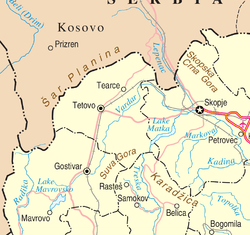 Map of northwestern Republic of Macedonia including the source of the Vardar
 Axios/Vardar river map
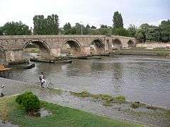
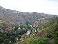 Veles Gorge
.JPG) River Vardar near Gradsko
River Vardar near Gradsko.JPG) River Vardar near Gradsko (2)
River Vardar near Gradsko (2)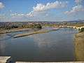 Vardar (Axios) river in Greece.
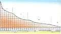 Longitudinal hidrographic profile of the flow of river Vardar
See also
References
- ↑ Official portal of the city of Skopje: City symbols. – Retrieved on 13 May 2009.
- ↑ Orel, Vladimir. A Handbook of Germanic Etymology. Leiden, Netherlands: Brill, 2003: 392.
- ↑ Mallory, J.P. and D.Q. Adams. Encyclopedia of Indo-European Culture. London: Fitzroy and Dearborn, 1997: 147
- ↑ Mallory, J.P. and D.Q. Adams. Encyclopedia of Indo-European Culture. London: Fitzroy and Dearborn, 1997, p. 146
- 1 2 Katičic', Radoslav. Ancient Languages of the Balkans. Paris: Mouton, 1976: 149
- ↑ Axios, Georg Autenrieth, A Homeric Dictionary, at Perseus
External links
| Wikimedia Commons has media related to Vardar. |
- Proceedings of the 1st Axios Catchment Consortium Meeting by the European Commission - DG Research.
- PIM "Ivan Milutinović", Belgrade, Serbia; Morava - Vardar (Axios) Navigation Route (About 1,200 km shorter route (three days shorter time of navigation) from Belgrade to Port of Thessaloniki than across Danube, Black Sea and Aegean Sea. Electric power production, improvement of water quality and regulation of flooding wave.)
- Morava - Vardar (Axios) Navigation Route map
- Hydropower and navigation system "Morava" (Concepts of regulation of rivers Great Morava and South Morava for navigation and hydropower production.)