Aweil, South Sudan
| Aweil | |
|---|---|
|
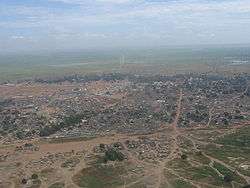
Aerial photo of Aweil (2007). The area has undergone significant development in the intervening years. | |
 Aweil Location in South Sudan | |
| Coordinates: 08°46′02″N 27°23′59″E / 8.76722°N 27.39972°E | |
| Country |
|
| State | Aweil State |
| County | Aweil Centre County |
| Government | |
| • State Governor | Gen. Akot Deng Akot |
| Elevation | 425 m (1,394 ft) |
| Population (2010) | |
| • Total | 33,537 |
| Climate | Aw |
Aweil is a city in South Sudan in Bahr el Ghazal region.
Location
Aweil is located in Aweil Centre County, Aweil State,[1] in northwestern South Sudan, near the International border with the Republic of Sudan and the Abyei Region. This location lies approximately 800 kilometres (500 mi), by road, northwest of Juba, the capital and largest city in the country.[2] The coordinates of Aweil are: 8° 46' 02.00"N, 27° 23' 59.00"E (Latitude: 8.7671; Longitude: 27.3998).
Overview
Aweil is the capital city of the state of Northern Bahr el Ghazal. It is also the county seat of Aweil Centre County. The city's infrastructure is relatively developed. Aweil. now has a functioning railway station, hotel, airport, soccer stadium, and a public hospital. The city functions as a team site for the United Nations Mission in Sudan. Several NGOs providing aid in South Sudan are based here.
The topography is flat and is prone to flooding, although the city itself lies on higher ground that the surrounding plains.[3] The city lies close to the confluence of the Lol River with the Pongo River. The average elevation of the city of Aweil is about 425 metres (1,394 ft) above sea level.[4] During the rainy season, the plain-dwellers seek refuge on higher ground in the city of Aweil.
Socially and economically vibrant, Aweil is one of the most peaceful cities within South Sudan's Ten States. Peace within the region has provided an economic boost, secondly most Aweilians remain unaffected by political decision making, they no longer have issues with cattle raiding and ethnic or tribal violence.
Demographic
The population of the Aweil city fluctuates. During the dry season, the population is lower as the plain-dwellers return to the plains to tend to their gardens and harvest their crops. When the rains come and the plains flood, they return to the city, to escape the raging waters. In November 2008, Médecins Sans Frontières estimated the town's population at about 100,000, but there is no verified population figure.[5]
Transport
Aweil has a railway station on the line to Wau built in the 1960s. After a period of disuse due to civil war damage, the line and the station were restored to use in 2010. The railway passes through Aweil South County to Wau. Aweil is served by Aweil Airport to Juba. In 2012 the local airline stopped flying.
Governance
The Governor of the state of Northern Bahr el Ghazal State is Gen. Akot Deng Akot. The Commissioner of Aweil Centre County is Deng Dhieu Nyiwel. The Mayor of the city of Aweil is Madam Nyibol Ajonga and there are many other ministerial positions of government in Northern Bahr El Ghazal State.
Points of interest
The following points of interest are found in or near Aweil:
- The headquarters of Northern Bahr el Ghazal State Administration
- The headquarters of Aweil Centre County Administration
- The offices of Aweil Town Council
- South Sudan Hotel - A private hospitality establishment
- Aweil Railway Station
- Aweil Airport
- Aweil Civil Hospital - One of the only three (3) referral hospitals in South Sudan
- St. George Catholic Church - A place of worship
- Aweil Rice Scheme
- Aweil Soccer Field
- University of Northern Bahr El-Ghazal
- St. Mary's Girls Secondary School - A secondary school for girls, owned and administered by the Aweil Dioceses of the Episcopal Church of the Sudan (ECS)[6]
See also
Notable people
References
- ↑ Additional Counties Established In Aweil East Gurtong
- ↑ Map Showing Juba And Aweil With Distance Marker
- ↑ Aweil Area Prone To Flooding
- ↑ Average Elevation of 1,394 Feet Above Sea Level
- ↑ Estimated Population of Aweil In November 2008 Archived October 2, 2011, at the Wayback Machine.
- ↑ About St. Mary's Girls School
External links
- Location of Aweil At Google Maps
- Detailed History of Aweil & Surrounding Communities
- Aweil Students graduates Network
| Wikimedia Commons has media related to Aweil. |
Coordinates: 08°46′48″N 27°24′00″E / 8.78000°N 27.40000°E