Aurskog-Høland
| Aurskog-Høland kommune | |||
|---|---|---|---|
| Municipality | |||
 | |||
| |||
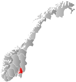
 Aurskog-Høland within Akershus | |||
| Coordinates: 59°50′24″N 11°34′6″E / 59.84000°N 11.56833°ECoordinates: 59°50′24″N 11°34′6″E / 59.84000°N 11.56833°E | |||
| Country | Norway | ||
| County | Akershus | ||
| District | Romerike | ||
| Administrative centre | Bjørkelangen | ||
| Government | |||
| • Mayor (2007) | Jan Mærli (Ap) | ||
| Area | |||
| • Total | 962 km2 (371 sq mi) | ||
| • Land | 894 km2 (345 sq mi) | ||
| Area rank | 111 in Norway | ||
| Population (2004) | |||
| • Total | 13,199 | ||
| • Rank | 79 in Norway | ||
| • Density | 15/km2 (40/sq mi) | ||
| • Change (10 years) | 7.3 % | ||
| Demonym(s) |
Aurskoging/Urskæving Hølending[1] | ||
| Time zone | CET (UTC+1) | ||
| • Summer (DST) | CEST (UTC+2) | ||
| ISO 3166 code | NO-0221 | ||
| Official language form | Bokmål | ||
| Website |
www | ||
|
| |||

Aurskog-Høland is a municipality in Akershus county, Norway. It is part of the Romerike traditional region. The administrative centre of the municipality is the village of Bjørkelangen.
General information
Name
The new municipality of Aurskog-Høland was created on 1 January 1966 after the merger of the four old municipalities of Aurskog, Nordre Høland, Søndre Høland, and Setskog.
The name Aurskog comes from the old Ør farm (Old Norse: Aurr which means "gravel"). The last element is skog (Old Norse: skógr which means "wood" therefore the meaning of the full name is "the woods around the farm Aurr". Prior to 1918, the name was written "Urskog".[2]
The name Høland is an old district name. The first element is høy which means "hay" and the last element is land which means "land".[2]
Coat-of-arms
The coat-of-arms is from modern times. They were granted on 4 February 1983. The arms show a black European crayfish (Astacus astacus) on a gold background. It was derived from an older logo of the municipality. The logo showed a typical landscape of the area, a lake surrounded by woods and a crayfish in the lake. To place the whole composition in a shield to create the arms was not allowed according to Norwegian heraldic rules, so the crayfish was chosen as a symbol.[3][4]
| Ancestry | Number |
|---|---|
| | 472 |
| | 219 |
| | 127 |
| | 104 |
| | 77 |
| | 53 |
| | 49 |
| | 41 |
Geography
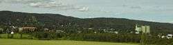
It is the biggest municipality in Akershus, covering 967 square kilometres (373.4 sq mi). Main villages are Aurskog and Bjørkelangen, of which the latter one is the administrative center. Forests cover much of the area, but there is very good farmland as well. The rivers of Haldenvassdraget and Hølandselva run through the district.
Economy
An important printing office, PDC Tangen AS and a crushing mill are situated here. Oslo is less than one hour's drive to the west.
The Think electric car was manufactured in Aurskog.
Sister cities
The following cities are twinned with Aurskog-Høland:[6]
-
 - Frederikssund, Region Hovedstaden, Denmark
 -
 - Kumla, Örebro County, Sweden
 -
 - Sipoo, Etelä-Suomi, Finland
See also
References
- ↑ "Navn på steder og personer: Innbyggjarnamn" (in Norwegian). Språkrådet. Retrieved 2015-12-01.
- 1 2 "Historie om Aurskog-Høland". Aurskog-Høland kommune. Retrieved 2008-12-17. (Norwegian)
- ↑ Norske Kommunevåpen (1990). "Nye kommunevåbener i Norden". Retrieved 2008-12-17.
- ↑ "Om Aurskog-Høland". Archived from the original on July 9, 2009. Retrieved 2008-12-17. (Norwegian)
- ↑ "Immigrants and Norwegian-born to immigrant parents, by immigration category, country background and percentages of the population". ssb.no. Retrieved 29 June 2015.
- ↑ "Vennskaps kommuner". Aurskog-Høland kommune. Retrieved 2008-12-17. (Norwegian)
External links
| Wikimedia Commons has media related to Aurskog-Høland. |
| Look up Aurskog-Høland in Wiktionary, the free dictionary. |
- Municipal fact sheet from Statistics Norway
-
 Akershus travel guide from Wikivoyage