Augusta, Kansas
| Augusta, Kansas | |
|---|---|
| City | |
 Location within Butler County and Kansas | |
 KDOT map of Butler County (legend) | |
| Coordinates: 37°41′33″N 96°58′48″W / 37.69250°N 96.98000°WCoordinates: 37°41′33″N 96°58′48″W / 37.69250°N 96.98000°W | |
| Country | United States |
| State | Kansas |
| County | Butler |
| Established | 1868 |
| Government | |
| • Mayor | Matt Childers |
| • City Manager | Josh Shaw |
| Area[1] | |
| • Total | 4.75 sq mi (12.30 km2) |
| • Land | 4.23 sq mi (10.96 km2) |
| • Water | 0.52 sq mi (1.35 km2) |
| Elevation | 1,276 ft (389 m) |
| Population (2010)[2] | |
| • Total | 9,274 |
| • Estimate (2015)[3] | 9,299 |
| • Density | 2,000/sq mi (750/km2) |
| Time zone | Central (CST) (UTC-6) |
| • Summer (DST) | CDT (UTC-5) |
| ZIP code | 67010 |
| Area code | 316 |
| FIPS code | 20-03300 [4] |
| GNIS feature ID | 0474806 [5] |
| Website | augustaks.org |
Augusta is a city in Butler County, Kansas, United States. As of the 2010 census, the city population was 9,274.[6][7]
History
19th century
The confluence of the Whitewater River and the Walnut River was originally inhabited by Osage people, who found the land ideal for hunting and fishing.
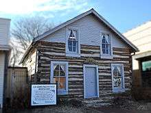
In 1868, C. N. James settled in the area and built a log cabin to serve also as a general store and trading post. Around that same time, a post office was established in the settlement, and as the first postmaster, C. N. James named the post office and the town in honor of his wife, Augusta James.[8][9][10]
In 1877, the Florence, El Dorado, and Walnut Valley Railroad Company built a branch line from Florence to El Dorado. In 1881 it was extended to Douglass, and later to Arkansas City.[11] The rail line was leased and operated by the Atchison, Topeka and Santa Fe Railway. Service from Florence to El Dorado was abandoned in 1942.[12] The original branch line connected Florence, Burns, De Graff, El Dorado, Augusta, Douglass, Rock, Akron, Winfield, Arkansas City.
The Frisco Railroad was later extended through Augusta.
20th century
The discovery of oil and natural gas in Butler County lead to further growth and became a major source of employment for many years. The closure of Mobil Refinery in 1983 marked a change in Augusta's commerce.
21st century
In 2010, the Keystone-Cushing Pipeline (Phase II) was constructed about 1.5 miles west of Augusta, north to south through Butler County, with much controversy over tax exemption and environmental concerns (if a leak ever occurs).[13][14]
Geography
Augusta is located at 37°41′33″N 96°58′48″W / 37.69250°N 96.98000°W (37.692425, -96.979886),[15] at the confluence of the Walnut and Whitewater Rivers. It is located along the western edge of Butler County. According to the United States Census Bureau, the city has a total area of 4.75 square miles (12.30 km2), of which, 4.23 square miles (10.96 km2) is land and 0.52 square miles (1.35 km2) is water.[1]
Climate
The climate in this area is characterized by hot, humid summers and generally mild to cool winters. According to the Köppen Climate Classification system, Augusta has a humid subtropical climate, abbreviated "Cfa" on climate maps.[16]
Demographics
| Historical population | |||
|---|---|---|---|
| Census | Pop. | %± | |
| 1880 | 922 | — | |
| 1890 | 1,343 | 45.7% | |
| 1900 | 1,197 | −10.9% | |
| 1910 | 1,235 | 3.2% | |
| 1920 | 4,219 | 241.6% | |
| 1930 | 4,033 | −4.4% | |
| 1940 | 3,821 | −5.3% | |
| 1950 | 4,483 | 17.3% | |
| 1960 | 6,434 | 43.5% | |
| 1970 | 5,977 | −7.1% | |
| 1980 | 6,968 | 16.6% | |
| 1990 | 7,876 | 13.0% | |
| 2000 | 8,423 | 6.9% | |
| 2010 | 9,274 | 10.1% | |
| Est. 2015 | 9,299 | [3] | 0.3% |
| U.S. Decennial Census | |||
2010 census
As of the census[2] of 2010, there were 9,274 people, 3,669 households, and 2,448 families residing in the city. The population density was 2,192.4 inhabitants per square mile (846.5/km2). There were 3,951 housing units at an average density of 934.0 per square mile (360.6/km2). The racial makeup of the city was 94.2% White, 0.4% African American, 1.3% Native American, 0.6% Asian, 0.1% Pacific Islander, 1.1% from other races, and 2.3% from two or more races. Hispanic or Latino of any race were 4.0% of the population.
There were 3,669 households of which 35.1% had children under the age of 18 living with them, 50.1% were married couples living together, 12.4% had a female householder with no husband present, 4.2% had a male householder with no wife present, and 33.3% were non-families. 29.3% of all households were made up of individuals and 14.9% had someone living alone who was 65 years of age or older. The average household size was 2.50 and the average family size was 3.10.
The median age in the city was 35.7 years. 27.9% of residents were under the age of 18; 8.4% were between the ages of 18 and 24; 25% were from 25 to 44; 23.2% were from 45 to 64; and 15.6% were 65 years of age or older. The gender makeup of the city was 47.2% male and 52.8% female.
2000 census
As of the census[4] of 2000, there were 8,423 people, 3,277 households, and 2,307 families residing in the city. The population density was 2,091.1 people per square mile (807.0/km²). There were 3,585 housing units at an average density of 890.0 per square mile (343.5/km²). The racial makeup of the city was 96.07% White, 0.18% African American, 0.83% Native American, 0.36% Asian, 0.68% from other races, and 1.89% from two or more races. Hispanic or Latino of any race were 2.59% of the population.
There were 3,277 households out of which 35.7% had children under the age of 18 living with them, 56.6% were married couples living together, 10.4% had a female householder with no husband present, and 29.6% were non-families. 26.3% of all households were made up of individuals and 12.5% had someone living alone who was 65 years of age or older. The average household size was 2.53 and the average family size was 3.06.
In the city the population was spread out with 28.0% under the age of 18, 8.9% from 18 to 24, 27.9% from 25 to 44, 19.4% from 45 to 64, and 15.7% who were 65 years of age or older. The median age was 35 years. For every 100 females there were 90.3 males. For every 100 females age 18 and over, there were 86.6 males.
The median income for a household in the city was $41,818, and the median income for a family was $51,886. Males had a median income of $36,465 versus $24,747 for females. The per capita income for the city was $19,094. About 4.1% of families and 5.7% of the population were below the poverty line, including 5.8% of those under age 18 and 7.5% of those age 65 or over.
Landmarks
The Augusta Historic Theater, now home to the Augusta Arts Council, is a classic example of Art Deco.[17] Augusta is also home to the Kansas Museum of Military History (formerly Augusta Air Museum). The Augusta Historical Museum and the C.N. James Log Cabin are on the National Register of Historic Places. Also Henry's Sculpture Hill is located outside the cities limit. Augusta does offer an airport called the Augusta Municipal Airport.
Media
Augusta is home to the Butler County Times-Gazette (formerly various local newspaper companies including the Augusta Gazette, Andover American, and El Dorado Times), a tri-weekly newspaper covering Augusta and neighboring towns.
Notable people
- Madelyn Dunham, grandmother of Barack Obama.
- Bob Whittaker, U.S. Representative from Kansas; resident of Augusta.[18]
See also
Further reading
References
- 1 2 "US Gazetteer files 2010". United States Census Bureau. Archived from the original on January 24, 2012. Retrieved 2012-07-06.
- 1 2 "American FactFinder". United States Census Bureau. Retrieved 2012-07-06.
- 1 2 "Annual Estimates of the Resident Population for Incorporated Places: April 1, 2010 to July 1, 2015". Retrieved July 2, 2016.
- 1 2 "American FactFinder". United States Census Bureau. Archived from the original on September 11, 2013. Retrieved 2008-01-31.
- ↑ "US Board on Geographic Names". United States Geological Survey. 2007-10-25. Retrieved 2008-01-31.
- ↑ "2010 City Population and Housing Occupancy Status". U.S. Census Bureau. Archived from the original on July 21, 2011. Retrieved March 6, 2011.
- ↑ http://www.augustagov.org/
- ↑ Mooney, Vol. P. (1916). History of Butler County Kansas. Standard Publishing Company. p. 95.
- ↑ "Kansas Post Offices, 1828-1961 (archived)". Kansas Historical Society. Archived from the original on October 9, 2013. Retrieved 5 June 2014.
- ↑ Historic letters found in Augusta; KAKE tv; January 20, 2015.
- ↑ Marion County Kansas : Past and Present; Sondra Van Meter; MB Publishing House; LCCN 72-92041; 344 pages; 1972.
- ↑ Railway Abandonment 1942
- ↑ Keystone Pipeline - Marion County Commission calls out Legislative Leadership on Pipeline Deal; April 18, 2010. Archived October 22, 2011, at the Wayback Machine.
- ↑ Keystone Pipeline - TransCanada inspecting pipeline; December 10, 2010.
- ↑ "US Gazetteer files: 2010, 2000, and 1990". United States Census Bureau. 2011-02-12. Retrieved 2011-04-23.
- ↑ Climate Summary for Augusta, Kansas
- ↑ http://augustahistorictheatre.com/
- ↑ "WHITTAKER, Robert Russell, (1939 - )". Biographical Directory of the United States Congress. Retrieved October 4, 2012.
External links
| Wikimedia Commons has media related to Augusta, Kansas. |
- City
- City of Augusta
- Augusta - Directory of Public Officials
- Downtown Augusta
- Augusta Chamber of Commerce
- Schools
- USD 402, local school district
- USD 402 School District Boundary Map, KDOT
- Maps
- Augusta City Map, KDOT
Municipalities and communities of Butler County, Kansas, United States | ||
|---|---|---|
| Cities |  | |
| CDP | ||
| Unincorporated communities | ||
| Ghost towns | ||
| Townships | ||
| Footnotes | ‡This populated place also has portions in an adjacent county or counties | |