Auderghem
| Auderghem Auderghem (French) Oudergem (Dutch) | |||
|---|---|---|---|
| Municipality | |||
 | |||
| |||
 Auderghem Location in Belgium | |||
|
Auderghem municipality in the Brussels-Capital Region  | |||
| Coordinates: 50°49′N 04°26′E / 50.817°N 4.433°ECoordinates: 50°49′N 04°26′E / 50.817°N 4.433°E | |||
| Country | Belgium | ||
| Community |
Flemish Community French Community | ||
| Region | Brussels | ||
| Arrondissement | Brussels | ||
| Government | |||
| • Mayor | Didier Gosuin (FDF) | ||
| Area | |||
| • Total | 9.03 km2 (3.49 sq mi) | ||
| Population (1 January 2016)[1] | |||
| • Total | 33,161 | ||
| • Density | 3,700/km2 (9,500/sq mi) | ||
| Postal codes | 1160 | ||
| Area codes | 02 | ||
| Website | www.auderghem.be | ||


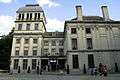
Auderghem (former Dutch spelling, now used in French; pronounced [odəʁˈɡem]) or Oudergem (Dutch: [ˈʌudərɣɛm]) is one of the nineteen municipalities located in the Brussels-Capital Region of Belgium.
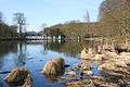
Located to the southeast of the capital, along the Woluwe valley and at the entrance to the Sonian Forest (Forêt de Soignes, Zoniënwoud), the municipality has an environmental advantage. Despite large roads slicing through and the increasing traffic, it has been able to preserve a relatively important part of its natural and historic legacy: the creeks, the Abbey of Rouge-Cloître or Rood Klooster (Red Cloister) and its art center, the Priory of Val Duchesse or Hertoginnedal (Duchess Dale), the Château of Trois Fontaines or Drie Fonteinen (Three Fountains), and the remarkable Chapel of Saint Anne.
Auderghem is adjacent to the municipalities of Etterbeek, Ixelles - Elsene, Woluwe-Saint-Pierre - Sint-Pieters-Woluwe, and Watermael-Boitsfort - Watermaal-Bosvoorde.
The municipality is governed by its 16th mayor, Didier Gosuin (FDF).
History
Three forest villages (Auderghem, Watermael, and Boitsfort-Bosvoorde), were one for centuries. In 1794, the soldiers of the French Revolution decided to separate these into three distinct municipalities. In 1811, Napoleon decided to reunite the three villages, by imperial decree, into a single administrative entity. But Auderghem was withdrawn from this union by royal act, leaving Watermael-Boitsfort on its own. Thus, Auderghem became an independent municipality in 1863, with only 1,600 inhabitants.
With the construction of the rail line linking Brussels and Tervuren as well as, in 1910, the construction of the Boulevard du Souverain or Vorstlaan, modernization came to the municipality and the population grew quickly.
In 1956, Paul Henri Spaak lead the Intergovernmental Conference on the Common Market and Euratom at the Val Duchesse castle in Auderghem, which prepared the Treaties of Rome in 1957 and the foundation of the European Economic Community and Euratom in 1958.
Demographics
As of 2004 the majority of Brussels' Japanese expatriate population lives in Auderghem.[2]
Sights
The Priory of Val Duchesse or Hertoginnedal, a gift of the king, is unfortunately rarely open to the public. In 1963, Belgium's cabinet ministers met here, planting the seeds of a federalization of the country though at conditions fiercely criticised especially in some extremist Flemish nationalist circles.
Similarly, the Chapel of Saint Anne, whose origins go back to the 12th century, is not open to the public. Decommissioned in 1843, it was sold several times. Its splendid sculptures from the Middle Ages and notable period furniture are still there to admire.
The municipality offers many green spaces.
-
The Castle of the Valley of the Duchess (Val Duchesse)
-

The Chapel of Saint Anne
Notable inhabitants
- Léon Huygens, painter (1876-1918)
Education
Public secondary schools from the French Community of Belgium:[3]
Subsidized religious secondary schools:[3]
- Centre scolaire St-Adrien Val Duchesse
- Institut St-Julien Parnasse
- Ecole Sainte-Bernadette
- Institut Dominique Pire
Subsidized non-religious secondary schools:[3]
- De l'autre côté de l'école
Private international schools:[3]
See also
References
- ↑ Population per municipality as of 1 January 2016 (XLS; 397 KB)
- ↑ State, Paul F. Historical Dictionary of Brussels. Scarecrow Press, July 27, 2004. ISBN 0810865556, 9780810865556. p. 21.
- 1 2 3 4 "Ecoles secondaires." Auderghem. Retrieved on September 12, 2016.
- ↑ "ブラッセル日本人学校 TOP:" The Japanese School of Brussels. Retrieved on 2 January 2014. "Avenue des Meuniers 133, 1160 Auderghem, Brussels, Belgium"
External links
| Wikimedia Commons has media related to Auderghem. |
- Official site of the Municipality of Auderghem (in French)
- Official site of the Municipality of Oudergem (in Dutch)
 |
Etterbeek | Woluwe-Saint-Pierre | | |
| Ixelles | |
Tervuren (VBR) | ||
| ||||
| | ||||
| Watermael-Boitsfort | |
Overijse (VBR) |
Brussels topics | ||||||||||||||||||||
|---|---|---|---|---|---|---|---|---|---|---|---|---|---|---|---|---|---|---|---|---|
| ||||||||||||||||||||
Portal | ||||||||||||||||||||