Auckland Region
Coordinates: 36°54′S 174°47′E / 36.900°S 174.783°E
| Auckland Region | |
| Country: | |
 | |
| Regional council | |
|---|---|
| Name: | Auckland Council |
| Mayor: | Phil Goff |
| Population: | 1,614,300 June 2016[1] |
| Land area: | 4,894 km2 (1,890 sq mi)[2] |
| Website: | aucklandcouncil.govt.nz |
| Cities and towns | |
| Largest city: | Auckland |
| Towns: | Orewa, Helensville, Warkworth, Wellsford, Pukekohe, Waiuku, Clevedon, Maraetai, Muriwai, Piha, Coatesville, Kumeu, Drury |
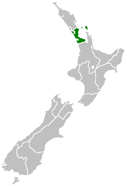
The Auckland Region is one of the sixteen regions of New Zealand, named for the city of Auckland, the country's largest urban area. The region encompasses the Auckland metropolitan area, smaller towns, rural areas, and the islands of the Hauraki Gulf. With 34 percent of the nation's residents,[1] it has by far the biggest population and economy of any region of New Zealand, but the second-smallest land area.
On 1 November 2010, the Auckland Region became a unitary authority controlled by the Auckland Council, replacing the previous regional council and seven local councils. In the process, an area in its southeastern corner was transferred to the neighbouring Waikato Region. The name "Auckland Region" remains present in casual usage.
Geography
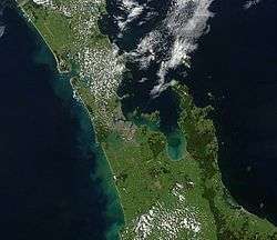
On the mainland, the region extends from the mouth of the Kaipara Harbour in the north across the southern stretches of the Northland Peninsula, past the Waitakere Ranges and the isthmus of Auckland and across the low-lying land surrounding the Manukau Harbour. The region ends within a few kilometres of the mouth of the Waikato River. It is bordered in the north by the Northland Region, and in the south by the Waikato Region. It also includes the islands of the Hauraki Gulf.
The Hunua Ranges and the adjacent coastline along the Firth of Thames were part of the region until the Auckland Council was formed in late 2010, when they were transferred to the neighbouring Waikato Region.
In land area it is smaller than all the other regions and unitary authorities except Nelson. Its highest point is the summit of Little Barrier Island, at 722 metres.
| # | Urban area | Population (June 2016)[1] |
% of region |
|---|---|---|---|
| 1 | Auckland | 1,495,000 | 92.6% |
| 2 | Pukekohe | 29,800 | 1.8% |
| 3 | Waiuku | 9,340 | 0.6% |
| 4 | Waiheke Island | 9,150 | 0.6% |
| 5 | Snells Beach | 4,800 | 0.6% |
| 6 | Warkworth | 4,650 | 0.3% |
| 7 | Helensville | 2,980 | 0.2% |
| 8 | Wellsford | 1,970 | 0.1% |
Territorial waters
The Pacific Ocean and Tasman Sea form the coastline around the Auckland region. The east coast is lapped by the waters of the Hauraki Gulf, an arm of the Pacific sheltered by a considerable number of small and large islands, notably Great Barrier Island in the northeast. An arm of the Gulf, the Waitemata Harbour, forms the main harbour of Auckland city, and also accommodates New Zealand's largest port. The mainland coastline is 1,613 kilometres (1,002 mi) long. Much of the coastal marine area comprises sensitive tidal inlets and estuaries and semi-enclosed Waitemata, Manukau and Kaipara Harbours.
To the west lie two large natural harbours, the Kaipara and the Manukau. Both of these have treacherous entrances and are little used by shipping. The Kaipara Harbour (of which the southern half is in the Auckland region) is one of the world's largest natural harbours, covering an area of 530 square kilometres (200 sq mi). The Manukau Harbour, located in the southwest part of the region, has a small port at Onehunga, but also suffers from difficult navigation – especially when the predominant southwesterly wind is blowing. Auckland Airport is located on the edge of the Manukau Harbour. The region is blessed with many fine beaches, especially on the Tasman coast south of the Kaipara. These include Muriwai and Piha beaches.
Geology
The Auckland Region is built on a basement of greywacke rocks that form many of the islands in the Hauraki Gulf, the Hunua Ranges, and land south of Port Waikato. The Waitakere Ranges in the west are the remains of a large andesitic volcano, and Great Barrier Island was formed by the northern end of the Coromandel Volcanic Zone. The main isthmus and North Shore are composed of Waitemata sandstone and mudstone, and portions of the Northland Allochthon extend as far south as Albany. Little Barrier Island was formed by a relatively isolated andesitic volcano, active around 1 to 3 million years ago.
The Manukau and South Kaipara Harbours are protected by the recent sand dune deposits of the Awhitu and South Kaipara Peninsulas. Recent basaltic volcanic activity has produced many volcanic cones throughout the Auckland Region, including the iconic Rangitoto Island.
Volcanic field
Much of Auckland's urban area lies on top of the dormant Auckland Volcanic Field. The region is dotted by 49 volcanoes of varying age with the oldest being in the region of 150,000 years old. The most recent eruption occurred approximately 600 years ago, ending a few hundred years of activity during which Rangitoto Island was formed.
Each volcanic eruption has tended to be bigger than the previous, with Rangitoto making up almost 60% of the entire volume of erupted material. All of the volcanoes are relatively small, most being less than 150 metres (490 ft) in height.
A large number of the Auckland volcanoes have been levelled or strongly altered – in small part due to historical Māori use of the cones as fortified pā or for terraced fields, but for most part having been quarried relatively recently for roading and construction materials (mainly scoria). However measures are now in place to preserve many of the remaining volcanoes as landmarks and parks.
People
Despite its small area, the region is by far the most populous in New Zealand, with a population of 1,614,300 (June 2016),[1] 34.4% of the country’s population. The Region is growing faster than any other part of the country except Tauranga, with its population increasing by over 240,000 (22%) in the past 10 years (according to Census data from 1996, 2001 and 2006). According to the 2001 Census, the Auckland Region contains 26.3 percent of New Zealand's European population, 24.3 percent of the Māori population, 66.7 percent of the Pacific peoples population, 63.7 percent of the Asian population and 54.7 percent of the population in the 'Other' ethnic groups category. These statistics highlight the ethnic diversity of the Auckland Region, compared to the rest of New Zealand.
Governance
Auckland Council
The Auckland Council is the local authority with jurisdiction over the Auckland Region. From 1989 to 2010 the region was under the jurisdiction of the Auckland Regional Council (successor of the Auckland Regional Authority) and seven territorial local authorities (which in turn replaced many smaller councils and boroughs). The Auckland Regional Council had fairly limited controls over the metropolitan area, focusing on environmental protection, public transport funding, and management of regional parks and coastal areas, while governance of other matters such as subdivision, infrastructure, services and land use was devolved to the territorial local authorities. The Auckland Council is a unitary authority exercising power over all these matters.
Health boards
Three District Health Boards (DHBs) cover the greater Auckland region. They are Waitemata Health, Auckland District Health Board, and Counties Manukau Health.
Transport
Transport in the Auckland Region is predominantly via motor vehicle, with much of New Zealand's motorway-grade roads being located in the region. However, there is also a commuter rail system linking the city centre with Waitakere and Manukau, and a relatively extensive bus system. However, even in the more urbanised parts of the region, public transport uptake is still low (though rising again since the 2000s) compared to many other western cities. Despite this, a significant part of all New Zealand public transport boardings take place in Auckland (see 'Statistics' section below).
Statistics
| Criterion (2007–2008)[3] | In Auckland Region | In New Zealand | % in Auckland Region |
|---|---|---|---|
| Population | 1,432,200 | 4,268,500 | 34 |
| Land area (km2) | 5600 | 275,400 | 2 |
| Imports (gross tonne) | 14.1 million | 79.2 million | 18 |
| Exports (gross tonne) | 8.3 million | 73.4 million | 11 |
| Gross domestic product (GDP) ($) | 42,200 million | 155,400 million | 27 |
| Passenger transport – bus – boardings | 43,165,200 | 92,777,200 | 47 |
| Passenger transport – rail – boardings | 6,794,100 | 18,346,600 | 37 |
| Passenger transport – ferry – boardings | 4,374,600 | 4,695,000 | 93 |
| Vehicle kilometres travelled | 12,200 million | 40,200 million | 30 |
| Fatalities (transport system) | 81 | 366 | 22 |
| State highways, all types (km) | 335 | 10,906 | 3 |
| State highways, motorways (km) | 106 | 172 | 62 |
See also
References
- 1 2 3 4 "Subnational Population Estimates: At 30 June 2016 (provisional)". Statistics New Zealand. 21 October 2016. Retrieved 21 October 2016. For urban areas, "Subnational population estimates (UA, AU), by age and sex, at 30 June 1996, 2001, 2006-16 (2017 boundary)". Statistics New Zealand. 21 October 2016. Retrieved 21 October 2016.
- ↑ "Auckland Council Draft Annual Plan 2011/2012 - Volume 1: Our Region" (PDF). Auckland Council. p. 2. Retrieved 9 March 2011.
- ↑ Overview of transport system – Table 1: Key statistics on the Auckland region (June 2007-July 2008) (from the National Land Transport Programme 2009–2012, Auckland, NZTA, August 2009. Accessed 2010-01-14.)
External links
 Media related to Auckland Region at Wikimedia Commons
 Auckland Region travel guide from Wikivoyage
-
 Geographic data related to Auckland Region at OpenStreetMap
 - Auckland Council
| North Island | ||
|---|---|---|
| South Island | ||
* Governed by a unitary authority rather than a regional council | ||