Aubaine, Côte-d'Or
| Aubaine | ||
|---|---|---|
 | ||
| ||
 Aubaine | ||
|
Location within Bourgogne-Franche-Comté region  Aubaine | ||
| Coordinates: 47°08′16″N 4°43′06″E / 47.1378°N 4.7183°ECoordinates: 47°08′16″N 4°43′06″E / 47.1378°N 4.7183°E | ||
| Country | France | |
| Region | Bourgogne-Franche-Comté | |
| Department | Côte-d'Or | |
| Arrondissement | Beaune | |
| Canton | Bligny-sur-Ouche | |
| Intercommunality | Bligny-sur-Ouche | |
| Government | ||
| • Mayor (2014–2020) | Monique Renaudin | |
| Area1 | 16.21 km2 (6.26 sq mi) | |
| Population (2010)2 | 95 | |
| • Density | 5.9/km2 (15/sq mi) | |
| Time zone | CET (UTC+1) | |
| • Summer (DST) | CEST (UTC+2) | |
| INSEE/Postal code | 21030 / 21360 | |
| Elevation |
380–611 m (1,247–2,005 ft) (avg. 611 m or 2,005 ft) | |
|
1 French Land Register data, which excludes lakes, ponds, glaciers > 1 km² (0.386 sq mi or 247 acres) and river estuaries. 2 Population without double counting: residents of multiple communes (e.g., students and military personnel) only counted once. | ||
Aubaine is a French commune in the Côte-d'Or department in the Bourgogne-Franche-Comté region of eastern France.
Geography
Aubaine is located some 17 km west of Nuits-Saint-Georges and 20 km north-west of Beaune. Access to the commune is by the D18 road from Crugey in the north-west passing through the north of the commune and continuing east then south to Beaune. The D104A road branches from the D18 west of the commune and goes south to the village then continues south to join the D970. The D104 comes from Bligny-sur-Ouche in the south-west passing through the south of the commune and going to Bouilland in the east. The A6 autoroute (E60) passes through the south of the commune but the nearest exit is Exit 24 near Beaune. Apart from the village there is the hamlet of Becoup in the north and Crépey in the south. The commune is mostly rugged and heavily forested but the north of the commune lies in the Ouche Valley and incorporates part of the hamlet of Pont-d'Ouche.[1]
The Ouche river forms the northern border of the north-western extension of the commune and the Canal de Bourgogne passes through the north of this extension.[1]
Crépey is at the intersection of roads from Aubaine, Beaune, and Arcenant and there was once a refreshment stall there.
Neighbouring communes and villages[1]
 |
Colombier | Antheuil | Détain-et-Bruant | |
| Thorey-sur-Ouche | |
Bouilland | ||
| ||||
| | ||||
| Lusigny-sur-Ouche | Bessey-en-Chaume | Savigny-lès-Beaune |
Toponymy
The name Aubaine has appeared in the following forms:
- Albania (1004)
- Aubeyne (1470)
- Albano,
- Aubaigne,
- Aubaingne,
- Aubainne.
Berthoud and Matruchot wrote that "The Albani theme is so transparent that it can not give rise to any doubt that it is the feminine of the man's name Albanius". Aubaine (villa) was literally the "domain of Albanius". L. Taverdet had a similar view: "Albania (villa) is an adjective formed on the name of the person Albanus". Father Bredault thought, to the contrary, that Aubaine came from the word Alb meaning "mountain".
The name Bécoup has appeared in the forms:
- Bivagum (696)
- Bouvacoum (878)
- Bescou (1290)
- Bescoul (1391) and
- Bivago.
The name Crépey has appeared in the forms:
- Crispeis (878)
- Crispiacus (1119)
- Crespee (19th century)
The Beaugey farm has appeared in the forms:
- Bouagez (1644)
- Beaugé (19th century).
History

A bronze statuette of a god with a mallet was found in Crépey - a demonstration of the survival of Celtic polytheism in the Gallo-Roman era.[2]
Around 1740, the priest at Aubaine responded to the engineer Antoine, who was developing a map of the province: "There is a tower with a very low spire. This is a simple lordship. It is located three leagues from Beaune to the south. The hamlets that dependent on my parish are: Bécoup to the north about a quarter of a league from my village, and Crespée located on top of a mountain between the east and the south. The village of Aubaine has in its immediate environment the wooded valleys of Aulne, Tilleul, Presme, and Oiseaux. At the bottom of the village is the source of the Saint-Quentin which releases water to join the Ouche at Pont-d'Ouche".[3]
Heraldry
.svg.png) |
Blazon: Party per fesse, at first party per pale: 1 of Argent, a cross pattée in Gules; 2 Azure, Semé-de-lis of Or with an inescutcheon bendy of Or and Azure bordure in Gules; at second Gules, a cross moline of Argent filled in with Sable. |
Administration
List of Successive Mayors[4]
| From | To | Name | Party | Position |
|---|---|---|---|---|
| 2001 | 2008 | Gabriel Moulin | DVG | |
| 2008 | 2014 | Jean-Louis-Royer | ||
| 2014 | 2020 | Monique Renaudin |
(Not all data is known)
Demography
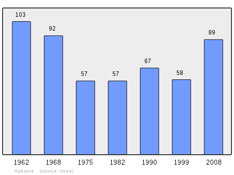
In 2010 the commune had 95 inhabitants. The evolution of the number of inhabitants is known from the population censuses conducted in the commune since 1793. From the 21st century, a census of communes with fewer than 10,000 inhabitants is held every five years, unlike larger towns that have a sample survey every year.[Note 1]
| 1793 | 1800 | 1806 | 1821 | 1831 | 1836 | 1841 | 1846 | 1851 |
|---|---|---|---|---|---|---|---|---|
| 321 | 330 | 347 | 385 | 413 | 393 | 411 | 409 | 414 |
| 1856 | 1861 | 1866 | 1872 | 1876 | 1881 | 1886 | 1891 | 1896 |
|---|---|---|---|---|---|---|---|---|
| 394 | 371 | 363 | 357 | 328 | 345 | 315 | 294 | 285 |
| 1901 | 1906 | 1911 | 1921 | 1926 | 1931 | 1936 | 1946 | 1954 |
|---|---|---|---|---|---|---|---|---|
| 254 | 228 | 224 | 168 | 147 | 198 | 218 | 165 | 130 |
| 1962 | 1968 | 1975 | 1982 | 1990 | 1999 | 2006 | 2010 | - |
|---|---|---|---|---|---|---|---|---|
| 103 | 92 | 57 | 57 | 67 | 58 | 81 | 95 | - |
Sources : Ldh/EHESS/Cassini until 1962, INSEE database from 1968 (population without double counting and municipal population from 2006)
Sites and monuments
Aubaine has several Distance Markers (16th century)![]() in the Forest of Crépey which are registered as historical monuments.[5]
in the Forest of Crépey which are registered as historical monuments.[5]
There are also the following places of interest in the commune:
- The Church of Aubaine has a Romanesque Apse and pre-choir.
- Lavoirs (Public laundries) in Aubaine, Bécoup, and Crépey.
- The source of the Saint-Quentin was formerly reputed to cure eye diseases.
- Two remarkable Wayside crosses[6] are located in Aubaine. The first, at the entrance to the village, probably dates to the 18th century - it includes statues of Christ and the Virgin in Relief. The second is next to a rural field called Champ de la Croix and dates to the 14th century - it consists of a Greek cross with Christ in bas-relief.
- A Bread oven in the hamlet of Crépey was a communal oven built in the 19th century then restored.
Cultural Events
The Festival of Bread is an event that has taken place since 1985 place around the communal oven every year on the 3rd Sunday in June with the participation of the Aubecray association (an association of law 1901, recreational, cultural, social, and conservation of local heritage activities).
See also
External links
- Canton of Bligny-sur-Ouche official website (French)
- Aubecray association website (French)
- Aubaine on the old IGN website (French)
- Aubaine on Google Maps
- Aubaine on Géoportail, National Geographic Institute (IGN) website (French)
- Aubaine on the 1750 Cassini Map
- Aubaine on the INSEE website (French)
- INSEE (French)
Notes and references
Notes
- ↑ At the beginning of the 21st century, the methods of identification have been modified by Law No. 2002-276 of 27 February 2002, the so-called "law of local democracy" and in particular Title V "census operations" allows, after a transitional period running from 2004 to 2008, the annual publication of the legal population of the different French administrative districts. For communes with a population greater than 10,000 inhabitants, a sample survey is conducted annually, the entire territory of these communes is taken into account at the end of the period of five years. The first "legal population" after 1999 under this new law came into force on 1 January 2009 and was based on the census of 2006.
References
- 1 2 3 Google Maps
- ↑ History of Beaune and its Surroundings, Lucien Perriaux, 1974 (French)
- ↑ Article from the Bien Public, Sunday, 25 January 2004 (French)
- ↑ List of Mayors of France (French)
- ↑ Ministry of Culture, Mérimée PA21000068 Distance markers (French)
- ↑ The Wayside crosses and the villages of the Canton of Bligny-sur-Ouche, Jean Salat, 2008 (French)
| Wikimedia Commons has media related to Aubaine. |