Atrato River
.svg.png)
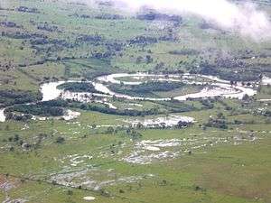
The Atrato River (Spanish: Río Atrato) is a river of northwestern Colombia. It rises in the slopes of the Western Cordillera and flows almost due north to the Gulf of Urabá (or Gulf of Darién), where it forms a large, swampy delta. Its course crosses the department of Chocó, forming that department's border with neighbouring Antioquia on two occasions. Its total length is about 650 km (400 mi), and it is navigable as far as Quibdó (400 km / 250 mi).
Flowing through a narrow valley between the Cordillera and coastal range, it has only short tributaries, the principal ones being the Truando River, the Sucio River, and the Murrí River. The gold and platinum mines of Chocó line some of its confluents, and the river sands are auriferous.
Northwestern Colombia encompasses an area of great diversity in wildlife. During the Pleistocene era at the height of the Atrato river, where it intersected the Cauca-Magdalena, the area was covered by a sea. It is proposed that this created a geographic barrier that may have caused many species to diverge through the process of allopatric speciation.[1] For example, Philip Hershkovitz proposed that the cotton-top tamarin (Saguinus oedipus) and the white-footed tamarin (Saguinus leocopus) diverged by the Atrato, and are today principally separated by the river.[1]
The Atrato at one time attracted considerable attention as a feasible route for a trans-isthmian canal, but any such plans were abandoned in favour of the Panama Canal.
References
 This article incorporates text from a publication now in the public domain: Chisholm, Hugh, ed. (1911). "Atrato". Encyclopædia Britannica (11th ed.). Cambridge University Press.
Coordinates: 7°22′56″N 77°06′39″W / 7.38222°N 77.11083°W