Atlasov Island
| Atlasov | |
|---|---|
| Alaid | |
 | |
| Highest point | |
| Elevation | 2,339 m (7,674 ft) [1] |
| Prominence | 2,339 m (7,674 ft) [1] |
| Listing | Ultra |
| Coordinates | 50°51′39″N 155°33′51″E / 50.86083°N 155.56417°ECoordinates: 50°51′39″N 155°33′51″E / 50.86083°N 155.56417°E [1] |
| Geography | |
 Atlasov | |
| Geology | |
| Mountain type | Stratovolcano |
| Last eruption | October to December 2012 |
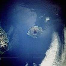
Atlasov Island, known in Russian as Ostrov Atlasova (Остров Атласова), or in Japanese as Araido (阿頼度島), is the northernmost island and volcano and also the highest volcano of the Kuril islands, part of the Sakhalin Oblast in Russia. The Russian name is sometimes rendered in English as Atlasova Island. Other names for the island include Uyakhuzhach, Oyakoba and Alaid, the name of the volcano on the island.
The island is named after Vladimir Atlasov, a 17th-century Russian explorer who incorporated the nearby Kamchatka Peninsula into Russia. It is essentially the cone of a submarine volcano called Vulkan Alaid protruding above the Sea of Okhotsk to a height of 2,339 metres (7,674 feet). The island has an area of 119 square kilometres (46 square miles), but is currently uninhabited. Numerous pyroclastic cones dot the lower flanks of basaltic to basaltic andesite volcano, particularly on the NW and SE sides, including an offshore cone formed during the 1933–34 eruption.[2]
Its near perfect shape gave rise to many legends about the volcano among the peoples of the region, such as the Itelmens and Kuril Ainu. The Russian scientist Stepan Krasheninnikov was told the story that it was once a mountain in Kamchatka, but the neighbouring mountains became jealous of its beauty and exiled it to the sea, leaving behind Kurile Lake in southern Kamchatka. Geographically, this story is not without evidence, as after the last Ice Age most of the icecaps melted, raising the world's water level, and possibly submerging a landbridge to the volcano. Following the transfer of the Kuril Islands to Japan by the Treaty of St Petersburg, 1875, Oyakoba as it is called by the Japanese, became the northernmost island of the empire and subject of much aesthetic praise, described in haiku, ukiyo-e, etc. Ito Osamu (1926) described it as more exquisitely shaped than Mount Fuji.
Administratively this island belongs to the Sakhalin Oblast of the Russian Federation.
See also
References
- 1 2 3 "Russia: Kamchatka and the Russian Pacific Islands Ultra-Prominence Page" Peaklist.org. Listed here as "Alaid V.". Retrieved 2011-11-27.
- ↑ "Alaid". Global Volcanism Program. Smithsonian Institution.
External links
- The Russian Kuril Islands Expedition to Atlasov
- Sakhalin Oblast
- "Vulkan Alaid, Russia" on Peakbagger
| Wikimedia Commons has media related to Atlasov Island. |