Atlantic Islands of Galicia National Park
| Atlantic Islands of Galicia | |
|---|---|
| Islas Atlánticas de Galicia | |
|
IUCN category II (national park) | |
|
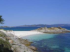
The Cies Islands | |
| Location | Pontevedra, Galicia, Spain |
| Nearest city | Vigo |
| Area | 8,480 hectares (84.8 km2; 32.7 sq mi) |
| Established | July 1, 2002 |
| Visitors | 238,939 (in 2007) |
| Governing body | Ministry of the Environment |
|
reddeparquesnacionales | |
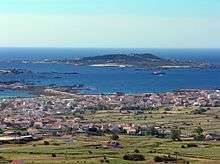
The Atlantic Islands of Galicia National Park (Galician: Parque Nacional das Illas Atlánticas de Galicia, Spanish: Parque Nacional de las Islas Atlánticas de Galicia) is the only national park located in the autonomous community of Galicia, Spain. It comprises the archipelagos of Cíes, Ons, Sálvora and Cortegada. The park covers a land area of 1,200 ha (3,000 acres) and a sea area of 7,200 ha (18,000 acres). It is the tenth most visited national park in Spain. It was the thirteenth national park to be established in Spain.
Flora and fauna

This sea-land ecosystem has a laurel forest and over 200 species of seaweed. It also stands out for its shellfish, corals and anemones. As for wildlife, one can see seagulls, shags, razorbills, guillemots and dolphins.
History
There are traces of human occupation in the islands since the Iron Age. Ceramics have also been found since Roman times. The islands were occupied by various monastic orders during the Middle Ages, were owned by the Church, gauged by nobles of the time and attacked by invaders who used them as a base for raids on the coast. More recently, the islands were inhabited until the eighteenth century, but by pirates' action, people had to abandon the islands. In 1980 the Cies Islands were declared a natural park. They are also a Special Protection Area for birds. On June 13, 2002 was declared a national park. However, 6 months later, the oil spill caused by the Prestige oil tanker came on its shores, except on the island of Cortegada. The islands of Loberiras and Sisargas could be added to the park in the future.
External links
- National Park info on the Spanish Environment Ministry website (Spanish)
- (Spanish)
Coordinates: 42°22′50″N 8°56′00″W / 42.3806°N 8.93333°W