Atka Island
| Atka Island | |
|---|---|
| Island | |
 Atka Island | |
| Coordinates: 52°08′17″N 174°26′43″W / 52.13806°N 174.44528°W | |
| Country | United States |
| State | Alaska |
| Archipelago | Andreanof Islands of the Aleutian Islands |
| Area[1] | |
| • Total | 404.93 sq mi (1,048.8 km2) |
| • Land | 404.6 sq mi (1,048 km2) |
| • Water | 0.33 sq mi (0.9 km2) |
| Population (2000)[1] | |
| • Total | 95 |
| • Density | 0.23/sq mi (0.091/km2) |
| ZIP code | 99547 |
Atka Island (Aleut: Atx̂ax̂[2]) is the largest island in the Andreanof Islands of the Aleutian Islands of Alaska. The island is 50 miles (80 km) east of Adak Island. It is 65 miles (105 km) long and 2–20 miles (3–30 km) wide with a land area of 404.6 square miles (1,048 km2), making it the 22nd largest island in the United States. The northeast of Atka Island contains the Korovin volcano which reaches a peak of 5,030 feet (1,533 m). Oglodak Island is located 3.4 miles (3.0 nmi; 5.5 km) off Cape Kigun, Atka's westernmost point.
The city of Atka, Alaska is on the east side of the island. The 2000 census population of the island was 95 persons, almost all in the city of Atka.[1]
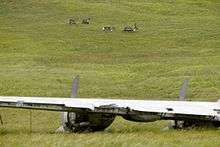
On December 5, 2008, President George W. Bush created the World War II Valor in the Pacific National Monument. A crashed B-24 Liberator on Atka is one of the 9 sites in the monument.
Education

Atka is served by the Aleutian Region Schools.
The Yakov E. Netsvetov School serves grades K-12.
References
- 1 2 3 Atka Island: Blocks 1085 thru 1100 and Block 1103, Census Tract 1, Aleutians West Census Area, Alaska United States Census Bureau
- ↑ Bergsland, K. (1994). Aleut Dictionary. Fairbanks: Alaska Native Language Center.
- Walter, Eugene; Katherine Clark (2002). "The Arctic Circle". Milking the Moon: A Southerner's Story of Life on This Planet. New York: Three Rivers Press. ISBN 0-609-80965-2. The author describes his three years serving on Atka as a military cryptologist during World War II.
| Wikimedia Commons has media related to Atka Island. |
Coordinates: 52°08′17″N 174°26′43″W / 52.13806°N 174.44528°W