Atherton, California
| Atherton, California | ||
|---|---|---|
| Town | ||
| Town of Atherton | ||
|
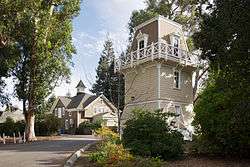
Holbrook-Palmer Park | ||
| ||
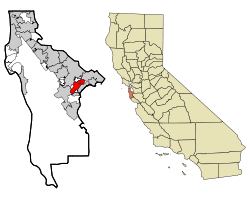 Location in San Mateo County and the state of California | ||
 Atherton, California Location in the United States | ||
| Coordinates: 37°27′31″N 122°12′0″W / 37.45861°N 122.20000°WCoordinates: 37°27′31″N 122°12′0″W / 37.45861°N 122.20000°W[1] | ||
| Country |
| |
| State |
| |
| County | San Mateo | |
| Incorporated | September 12, 1923[2] | |
| Named for | Faxon Dean Atherton[2] | |
| Government | ||
| • City council[3] |
Mayor Elizabeth Lewis, Vice Mayor Michael Lempres, Cary Wiest, Bill Widmer, and Rick DeGolia | |
| • Assemblymember | Marc Berman (D) (24th)[4] | |
| • State Senator | Jerry Hill (D) (13th)[4] | |
| • U. S. Rep. | Anna Eshoo (D) (18th)[5] | |
| Area[6] | ||
| • Total | 5.049 sq mi (13.076 km2) | |
| • Land | 5.017 sq mi (12.993 km2) | |
| • Water | 0.032 sq mi (0.082 km2) 0.63% | |
| Elevation[1] | 59 ft (18 m) | |
| Population (April 1, 2010)[7] | ||
| • Total | 6,914 | |
| • Estimate (2013)[7] | 7,159 | |
| • Density | 1,400/sq mi (530/km2) | |
| Time zone | Pacific (UTC-8) | |
| • Summer (DST) | PDT (UTC-7) | |
| ZIP code[8] | 94027 | |
| Area code[9] | 650 | |
| FIPS code | 06-03092 | |
| GNIS feature IDs | 1657960, 2411651 | |
| Website |
www | |
Atherton is an incorporated town in San Mateo County, California, United States. Its population was 7,159 as of 2013.
History
In 1866, Atherton was known as Fair Oaks, and was a flag stop on the California Coast Line of the Southern Pacific Railroad between San Francisco and San Jose for the convenience of the owners of the large estates who lived north of Menlo Park. The entire area was called Menlo Park. It had been part of the Rancho de las Pulgas that had covered most of the area, which is now southern San Mateo County. There were several attempts to incorporate Fair Oaks, one in 1874 and another in 1911.
In 1923, Menlo Park wished to incorporate its lands to include the Fair Oaks lands. During a meeting of the representatives of the two communities, it became clear to the Fair Oaks property owners that in order to maintain their community as a strictly residential area, they would have to incorporate separately. Both groups rushed to Sacramento but the Fair Oaks committee arrived first. It was at that time they realized that they could not keep the name Fair Oaks, as it was already the name of a town near Sacramento. It was decided to honor Faxon Dean Atherton who had been one of the first property owners in the south peninsula and name the Town for him. Atherton was incorporated on September 12, 1923. That same year, in 1923, the Menlo Polo Club was founded in Atherton.[10][11]
Faxon D. Atherton, a native of Massachusetts, had spent several years in Chile and Hawaii as a trader in tallow, hides and merchandise. His friend and business associate, Thomas Lark had written to him "there is education available for your children and a dignity of living on landed estates down the San Francisco peninsula (that is) convenient and accessible." Atherton purchased 640 acres (2.6 km2) for ten dollars an acre ($2470/km²)in 1860. His home, "Valparaíso Park", was built several years later. It was simple in design and ample for his family of seven children.
Because of the development of the railroad, other San Franciscans traveled south and established summer homes. Because the dirt roads were usually impassable in the winter, the families were only in residence from May through September.
Thomas H. Selby purchased 420 acres (1.7 km2). A successful businessman, he served as mayor of San Francisco. His country estate was called "Almendral". John T. Doyle, an attorney, built a home off Middlefield Road, "Ringwood". James C. Flood purchased successive parcels and built an extravagant mansion, "Linden Towers".This is now Lindenwood. The Joseph A Donohoe estate was "Holmgrove" and is now the site of Menlo Atherton High School. James Thomas Watkins' home was "Fair Oaks" and after two moves, stands restored today on Alejandra Avenue.
The government was established with Edward E. Eyre as the first mayor. In 1928, the residents voted to build a Town Hall, which stands today. The early residents wanted a Town that would be divided into large parcels and would not contain businesses. The author Gertrude Atherton, daughter-in-law to Faxon D. Atherton wrote in "The Californians", "Menlo Park (Atherton) has been cut up into country places for what might be termed the 'old families of San Francisco', the eight or ten families who owned the haughty precinct were as exclusive, as conservative, as any group of ancient country families in Europe." A few of the large land holdings were subdivided during the 1920s and 1930s, James Flood estate in 1938. In the 1940s and 1950s over eighty subdivisions were recorded. With the minimum size of one acre (4,000 m²), the era of the large estates was over. Atherton is still a "plain of oaks". Native live oaks, white oaks, bays, redwoods, cedars, pines and other ornamental trees cover the six square miles (16 km²) of town. There are approximately 50 miles (80 km) of roads. The population is around 7500 with approximately 2500 households.
Olive Holbrook-Palmer left Holbrook-Palmer Park, a 22-acre (89,000 m²) park, to the Town in 1958. It is an open, tree-covered park, which offers recreational programs and has facilities for functions.
Geography
Atherton is located at 37°27′31″N 122°12′00″W / 37.458615°N 122.200099°W.[12]
According to the United States Census Bureau, the town has a total area of 5.0 square miles (13 km2), of which, 5.0 square miles (13 km2) of it is land and 0.03 square miles (0.078 km2) of it (0.63%) is water.
Atherton lies two miles (3 km) southeast of Redwood City, and 18 miles (29 km) northwest of San Jose. The town is considered to be part of the San Francisco metropolitan area.
The town has a Caltrain station with service only on weekends.
Culture and contemporary life
There are a number of active community organizations; the Atherton Heritage Association, the Atherton Arts Committee, the Atherton Tree Committee, the Friends of the Atherton Community Library, the Holbrook-Palmer Park Foundation, the Atherton Dames, the Police Task force, and the Atherton Civic Interest League. There are also home owners' associations. The Menlo Circus Club is a private club with stables and a riding ring located within the town.
There are also several tracts of contemporary Eichler homes, most notably in the Lindenwood neighborhood.[13]
Government
Atherton's current land use goal is "To preserve the Town's character as a scenic, rural, thickly wooded residential area with abundant open space."[14]
In the California State Legislature, Atherton is in the 13th Senate District, represented by Democrat Jerry Hill, and in the 24th Assembly District, represented by Democrat Marc Berman.[15]
In the United States House of Representatives, Atherton is in California's 18th congressional district, represented by Democrat Anna Eshoo.[16]
The city is served by the Atherton Public Library of the San Mateo County Library, a member of the Peninsula Library System.
Demographics
| Historical population | |||
|---|---|---|---|
| Census | Pop. | %± | |
| 1930 | 1,324 | — | |
| 1940 | 1,908 | 44.1% | |
| 1950 | 3,630 | 90.3% | |
| 1960 | 7,717 | 112.6% | |
| 1970 | 8,085 | 4.8% | |
| 1980 | 7,797 | −3.6% | |
| 1990 | 7,163 | −8.1% | |
| 2000 | 7,194 | 0.4% | |
| 2010 | 6,914 | −3.9% | |
| Est. 2015 | 7,167 | [17] | 3.7% |
In September 2010, Forbes magazine placed Atherton's ZIP code of 94027 at #2 on its annual list of America's most expensive zip codes.[19][20] In October 2013, 94027 moved to #1 on the list, where it remained for 2014 and 2015. In context, Beverly Hills was placed at #14 in 2015.[21] Atherton is one of the wealthiest cities in the United States.[20]
2000
As of the census[22] of 2000, there were 7,194 people, 2,413 households, and 1,984 families residing in the town. The population density was 1,467.6 people per square mile (566.9/km²). There were 2,505 housing units at an average density of 511.0 per square mile (197.4/km²).
There were 2,413 households out of which 33.3% had children under the age of 18 living with them, 75.6% were married couples living together, 4.5% had a female householder with no husband present, and 17.8% were non-families. 12.8% of all households were made up of individuals and 7.5% had someone living alone who was 65 years of age or older. The average household size was 2.85 and the average family size was 3.06.
In the town the population was spread out with 23.7% under the age of 18, 7.2% from 18 to 24, 18.7% from 25 to 44, 30.3% from 45 to 64, and 20.2% who were 65 years of age or older. The median age was 45 years. For every 100 females there were 93.6 males. For every 100 women age 18 and over, there were 90.2 men.
The median income for a household in the town was in excess of $200,000, as is the median income for a family. Males had a median income of over $100,000 versus $68,393 for females. The per capita income for the town was $112,408. About 0.8% of families and 1.7% of the population were below the poverty line, including 0.6% of those under age 18 and 3.3% of those age 65 or over.
Unlike most of San Mateo County, 55% of Atherton voters are registered Republicans, and 27.8% are registered Democrats.[23]
Forbes ranks Atherton as second on its list of America's Most Expensive ZIP Codes, listing median house price as over $2,000,000.[24]
2010
The 2010 United States Census[25] reported that Atherton had a population of 6,914. The population density was 1,369.5 people per square mile (528.8/km²). The racial makeup of Atherton was 5,565 (80.5%) White, 75 (1.1%) African American, 7 (0.1%) Native American, 911 (13.2%) Asian, 45 (0.7%) Pacific Islander, 95 (1.4%) from other races, and 216 (3.1%) from two or more races. Hispanic or Latino of any race were 268 persons (3.9%).
The census reported that 6,529 people (94.4% of the population) lived in households, 385 (5.6%) lived in non-institutionalized group quarters, and 0 (0%) were institutionalized.
There were 2,330 households, out of which 787 (33.8%) had children under the age of 18 living in them, 1,755 (75.3%) were opposite-sex married couples living together, 109 (4.7%) had a female householder with no husband present, 48 (2.1%) had a male householder with no wife present. There were 34 (1.5%) unmarried opposite-sex partnerships, and 15 (0.6%) same-sex married couples or partnerships. 321 households (13.8%) were made up of individuals and 178 (7.6%) had someone living alone who was 65 years of age or older. The average household size was 2.80. There were 1,912 families (82.1% of all households); the average family size was 3.03.
The population was spread out with 1,543 people (22.3%) under the age of 18, 579 people (8.4%) aged 18 to 24, 966 people (14.0%) aged 25 to 44, 2,264 people (32.7%) aged 45 to 64, and 1,562 people (22.6%) who were 65 years of age or older. The median age was 48.2 years. For every 100 females there were 96.6 males. For every 100 women age 18 and over, there were 95.3 men.
The median income for a household in the town was in excess of $250,000, the highest of any place in the United States.[26] The per capita income for the town was $128,816. About 2.9% of families and 5.1% of the population were below the poverty line, including 5.6% of those under age 18 and 5.4% of those age 65 or over.
There were 2,530 housing units at an average density of 501.1 per square mile (193.5/km²), of which 2,116 (90.8%) were owner-occupied, and 214 (9.2%) were occupied by renters. The homeowner vacancy rate was 1.6%; the rental vacancy rate was 3.9%. 5,921 people (85.6% of the population) lived in owner-occupied housing units and 608 people (8.8%) lived in rental housing units.
Politics
The town of Atherton is the most Republican political subdivision in heavily Democratic San Mateo County. According to the California Secretary of State, as of October 22, 2012, Atherton has 5,052 registered voters. Of those, 2,071 (41.0%) are registered Republicans, 1,629 (32.2%) are registered Democrats, and 1,186 (23.5%) have declined to state a political party.[27]
Atherton is one of the few remaining cities or towns in the San Francisco Bay Area to have a plurality of Republican registered voters. The others include the affluent towns of Clayton, Danville and Hillsborough.
Education
Among Atherton's public schools, Encinal, Las Lomitas, and Laurel are elementary schools, while Selby Lane is both an elementary and a middle school. Menlo-Atherton is a high school. Atherton does not have its own public school system. Selby Lane is part of the Redwood City School District, the high school is part of the Sequoia Union High School District, Las Lomitas Elementary School is part of the Las Lomitas Elementary School District, and both Encinal and Laurel are part of the Menlo Park City School District.
Among the town's private schools, St. Joseph's is an elementary and middle school, Sacred Heart is a high school, and Menlo School is a middle and high school.
Menlo College is a private four-year college.
Notable residents
- Gertrude Atherton, American author
- CiCi Bellis, tennis player
- Lindsey Buckingham, of Fleetwood Mac[28]
- Cheryl Burke, Dancing with the Stars professional dancer
- Ty Cobb, Hall of Fame Major League Baseball player
- Timothy C. Draper, venture capitalist and founder of Draper Fisher Jurvetson[29]
- Clay Dreslough, game designer, raised in Atherton
- Douglas Engelbart, computer engineer
- Drew Fuller, actor, known for role on Charmed, and Army Wives
- Ron Johnson, former senior executive at Apple
- Guy Kawasaki, venture capitalist
- Bobbie Kelsey, Stanford University women's basketball assistant coach
- Andy Kessler, author of books on business, technology, and the health field
- Charlie Kubal, music producer, created 2010's Mashup Album of the Year the notorious xx, grew up in Atherton
- Andy W. Mattes, CEO of Diebold.[30]
- Willie Mays, Hall of Fame Major League Baseball player.[31]
- Rajeev Motwani, professor, computer science, Stanford University[32]
- Farzad Nazem, was Yahoo!'s chief technology officer and one of its longest-serving executives, and is now an angel investor
- Tom Proulx, co-founder of Intuit[33]
- Vivek Ranadive, Chairman, CEO and Founder of TIBCO Software[34]
- Jerry Rice, former football player[35]
- Ted Robinson, San Francisco 49ers play-by-play announcer
- Sheryl Sandberg, Chief Operating Officer of Facebook
- Eric Schmidt, Executive Chairman and former CEO of Google; 138th-richest person in the world in 2012[36]
- Charles R. Schwab, founder and CEO of the Charles Schwab Corporation[37]
- Shirley Temple, child movie star and diplomat
- Bob Weir, of the Grateful Dead and Ratdog, raised in Atherton.[38]
- Steve Westly, former State Controller of California, major Democratic Party fundraiser, and venture capitalist.[39]
- Meg Whitman, president and CEO of Hewlett-Packard, former CEO of eBay, former Finance co-chair of Republican Mitt Romney's 2008 Presidential Campaign and national co-chair for Republican John McCain's 2008 Presidential Campaign, the Republican nominee for Governor of California.[40]
- Maureen Kennedy Salaman, author and proponent of alternative medicine
References
- 1 2 "Atherton". Geographic Names Information System. United States Geological Survey. Retrieved August 21, 2009.
- 1 2 "Atherton History". Town of Atherton. April 27, 2007. Retrieved August 21, 2009.
- ↑ "City Council". Town of Atherton. Retrieved December 29, 2014.
- 1 2 "Statewide Database". UC Regents. Retrieved December 29, 2014.
- ↑ "California's 18th Congressional District - Representatives & District Map". Civic Impulse, LLC. Retrieved March 13, 2013.
- ↑ "2010 Census Gazetteer Files – Places – California". United States Census Bureau. Retrieved March 26, 2015.
- 1 2 "Atherton (city) QuickFacts". United States Census Bureau. Retrieved February 22, 2015.
- ↑ "USPS – ZIP Code Lookup – Search By City". United States Postal Service. Archived from the original on August 30, 2009. Retrieved August 21, 2009.
- ↑ "NANP Administration System". North American Numbering Plan Administration. Retrieved August 21, 2009.
- ↑ Menlo Polo Club
- ↑ Angella Sprauve, Polo in Silicon Valley widens field for newcomers, Haute Living, October 20, 2012
- ↑ "US Gazetteer files: 2010, 2000, and 1990". United States Census Bureau. 2011-02-12. Retrieved 2011-04-23.
- ↑ http://lindenwoodeichlers.com/lindenwood.html
- ↑ Town of Atherton General Plan (PDF). Neal Martin & Associates. November 20, 2002. pp. LU–1. Retrieved August 22, 2009.
- ↑ "Statewide Database". UC Regents. Retrieved November 23, 2014.
- ↑ "California's 18th Congressional District - Representatives & District Map". Civic Impulse, LLC.
- ↑ "Annual Estimates of the Resident Population for Incorporated Places: April 1, 2010 to July 1, 2015". Retrieved July 2, 2016.
- ↑ "Census of Population and Housing". Census.gov. Archived from the original on May 11, 2015. Retrieved June 4, 2015.
- ↑ "America's Most Expensive ZIP Codes". Forbes.
- 1 2 Archive of "1990 CPH-L-126. Median Family Income for Places with a Population of 2,500 to 9,999, Ranked Within the United States: 1989", United States Census Bureau. 1990 CPH-L-126F.html Original page
- ↑ America's Most Expensive Zip Codes In 2013: The Complete List, by Morgan Brennan, Forbes magazine, 16 October 2013
- ↑ "American FactFinder". United States Census Bureau. Archived from the original on September 11, 2013. Retrieved 2008-01-31.
- ↑ "Senate District 11". California State Senate. December 2, 2004. Archived from the original on August 20, 2009. Retrieved August 21, 2009.
- ↑ Levy, Francesca (September 27, 2010). "America's Most Expensive ZIP Codes". Forbes.
- ↑ "2010 Census Interactive Population Search: CA - Atherton town". U.S. Census Bureau. Retrieved July 12, 2014.
- ↑ "Highest Income Per Household In The United States By City".
- ↑ CA Secretary of State – Report of Registration – October 22, 2012
- ↑ "Lindsay Buckingham with Special Guest Stevie Nicks". Soundstage. HD READY, LLC and WTTW. 2005. Archived from the original on March 3, 2009. Retrieved January 18, 2009.
- ↑ Palmeri, Christopher; Linda Himelstein (November 6, 2000). "Tim Draper's Voucher Crusade". BusinessWeek. The McGraw-Hill Companies Inc. Archived from the original on September 22, 2010. Retrieved June 25, 2009.
- ↑ Cho, Janet H. (June 7, 2013). "New Diebold CEO Andy W. Mattes plans to be direct and ask lots of questions as he steers the company back on track". The Plain Dealer. Retrieved October 30, 2016.
He has also worked in China and Brazil, and now lives in Atherton, Calif.
- ↑ Taylor, Phil (July 11, 2008). "Willie Mays: An American Giant". SI Vault. Time Inc. A Time Warner Company. Retrieved June 25, 2009.
- ↑ AP Associated Press (June 8, 2009). "Stanford computer prof. Rajeev Motwani found dead". SFGate. Hearst Communications Inc. Archived from the original on June 11, 2009. Retrieved June 25, 2009.
- ↑ Cortese, Amy (August 7, 1997). "MY JET IS BIGGER THAN YOUR JET". BusinessWeek. The McGraw-Hill Companies Inc. Archived from the original on November 8, 2009. Retrieved June 25, 2009.
- ↑ "The Buzz – the week that was". SFGate. Hearst Communications Inc. June 21, 2009. pp. K–1 of the San Francisco Chronicle. Retrieved June 25, 2009.
- ↑ The Associated Press (June 6, 2001). "Jerry Rice becomes newest Oakland Raider". The Berkeley Daily Planet. Retrieved June 25, 2009.
- ↑ Hansell, Saul (August 8, 2005). "Google's Chief Is Googled, to the Company's Displeasure". The New York Times. The New York Times Company. Retrieved January 18, 2009.
- ↑ "#58 Charles R Schwab". The 400 Richest Americans. Forbes.com LLC. 2009. Retrieved January 18, 2009.
- ↑ McNally, Dennis. A Long Strange Trip: The Inside History of the Grateful Dead. New York: Broadway Books, 2002. ISBN 0-7679-1185-7
- ↑ "Google staffers quiz candidate Obama". USA Today. USA TODAY, a division of Gannett Co. Inc. November 15, 2007. Retrieved January 18, 2009.
- ↑ "Archived copy" (PDF). Archived from the original (PDF) on November 27, 2008. Retrieved 2009-04-23.
External links
| Wikimedia Commons has media related to Atherton, California. |
Municipalities and communities of San Mateo County, California, United States | ||
|---|---|---|
| Cities and towns | 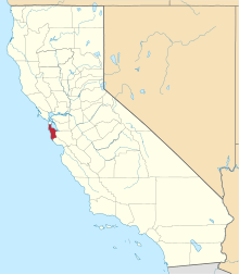 | |
| CDPs | ||
| Unincorporated communities | ||
| Ghost towns | ||
| Bodies of water |
|  |
|---|---|---|
| Counties | ||
| Major cities | ||
| Cities and towns 100k–250k | ||
| Cities and towns 50k–99k | ||
| Cities and towns 25k-50k | ||
| Cities and towns 10k–25k |
| |
| Sub-regions | ||