Astove Island
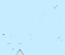 Astove Atoll Location of Astove Atoll in Seychelles | |
| Geography | |
|---|---|
| Location | Indian Ocean |
| Coordinates | 10°06′S 47°45′E / 10.100°S 47.750°ECoordinates: 10°06′S 47°45′E / 10.100°S 47.750°E |
| Archipelago | Seychelles |
| Adjacent bodies of water | Indian Ocean |
| Total islands | 15 |
| Major islands |
|
| Area | 7.9 km2 (3.1 sq mi) |
| Highest elevation | 18 m (59 ft) |
| Administration | |
| Group | Outer Islands |
| Sub-Group | Aldabra Group |
| Sub-Group | Astove Atoll |
| Districts | Outer Islands District |
Largest settlement |
Astove (population 2) |
| Demographics | |
| Demonym | Creole |
| Population | 2 (2016) |
| Pop. density | 0.25 /km2 (0.65 /sq mi) |
| Ethnic groups | Creole, French, East Africans, Indians. |
| Additional information | |
| Time zone | |
| Official website |
www |
| ISO Code = SC-26 | |
Astove Atoll is a large atoll, part of the Aldabra Group, lying in the Outer Islands of Seychelles, with a distance of 1,041 km (647 mi) southwest of the capital, Victoria, on Mahé Island.
History
The name Astove is said to be derived from the Portuguese As Doze Island, meaning the twelve islands, which may have been the original Portuguese name for Farquhar.[1] Much of the region in which Astove lies was explored by Arab seamen and merchants between 1000 and 1500 AD, but there is no record of human settlement on the island before 1760. In that year, the Portuguese frigate La Dom Royal, laden with plunder and slaves, went aground at Astove. All aboard made it to the island, but the captain and crew soon abandoned Astove and struck out for Mozambique in a long boat. They never returned for the slaves, who organized into a community and subsisted on the bounty of the island and the sea.[2]
A passing ship reported that there was “a treasure trove of slaves” to be had for the taking from Astove, but repeated efforts to capture them failed when almost all the ships foundered, as had the La Dom Royal. In 1796, a British ship attempted to remove the slaves by force – and succeeded in embarking some 100 of them – but the slaves revolted and helped thwart the effort, which failed completely when the ship foundered. There was, reportedly, great loss of life in the shark-infested waters.
The remaining slaves on Astove were eventually picked up and evacuated to Mahe, leaving one sole survivor named “Paul” on the island. In 1799, a passing ship stopped at Astove and a search was made for this lone slave, but no trace of him could be found.[2]
On the morning of August 12, 1836, the ship Tiger of Liverpool, which was commanded by Captain Edward Searight, was wrecked on the reef of Astove atoll. An account by William Stirling was published seven years later.
Human presence at Astove remained inconsistent throughout the 19th century and centered largely upon harvesting operations that were under way at the time. Astove was heavily mined for guano and phosphates, and hunted for its sea turtles, but for the most part remained not visited due to its remoteness and distance from normal shipping lanes.
In 1968, Astove atoll was occupied by British adventurer and businessman Mark Veevers-Carter and his American wife, Wendy (Day) Veevers-Carter, who was the daughter of American author Clarence Day (Life With Father). The couple had founded, operated and sold a successful copra plantation on the Seychelles island of Remire, and sought to do the same on the much larger island of Astove.[3]
“When we landed on Astove, we found palm trees, a roofless wooden house and a graveyard,” wrote Wendy Veevers-Carter. “Part of the British-governed Seychelles, Astove was a ‘lost’ island.”
The Veevers-Carters built a 14-room house, a processing center, a chapel, a store and small residences for their Seychelleois employees. While copra constituted the primary cash crop, the Veevers-Carters plantation also grew tobacco and raised, for subsistence, goats, cattle and pigs. The life of the couple and their three children were chronicled by Wendy Veevers-Carter in an article for Parade magazine in June 1969.[4]
“Mark has had painful trouble with his teeth but has borne the agony stoically,” she wrote in the article. “He must see a dentist soon, but that will mean a trip of many days.”
Her husband’s dental problems necessitated a March 1970 journey to Kenya for medical treatment. He took with him the couple’s broken short-wave radio and one of their three children, leaving his wife and their two sons on the plantation at Astove. On March 11, the 42-year-old Veevers-Carter died under anesthesia in the dentist’s chair, but because there was no radio on Astove, word could not be quickly delivered to his wife.
Ten days after Veevers-Carter’s death, the news was delivered to his family by the Kenyan cement carrier Bamburi, which took them to Kenya.[5]
Wendy Veevers-Carter tried to manage Astove alone until November 1970, but found the task impossible. Returning to the United States with her children, she left Astove in the care of three Seychellois employees. Although she expressed hope in maintaining control over and access to Astove, she never returned and the island was abandoned.[6] In 1911, Treasure hunters found near Astove the wrecked Portuguese ship, La Dom Royal, that sank in 1760. They dug up the entire wreckage and found gold and silver.[7][8] In 2014 Astove was declared a nature reserve, IDC established a station there and built an eco-friendly lodge.
Geography
Astove atoll is located 35 kilometres (22 miles) SSE of Cosmoledo Atoll. It is a raised coral island of most peculiar form: a single stretch of land, that is 1.4 kilometres (0.9 miles) at the widest part, almost entirely encloses a shallow lagoon. The lagoon has a maximum depth of 3 metres (9.8 feet), and the only exit is a winding passage in the south, called Gueule Bras Channel. The lagoon includes some sandbanks and islands inside it.
Astove atoll measures 6 km (3.7 mi) north to south and 4 km (2.5 mi) east to west. The land area is 7.9 square kilometres (3.1 square miles), and the total area including the lagoon and reef is 21.2 square kilometres (8.2 square miles).[9]
List of islets
| Island | type | Area (hectares) | Location | |
|---|---|---|---|---|
| 1 | Astove | island | 775.22 | 10°05′S 47°44′E / 10.083°S 47.733°E |
| 2 | Gueule Bras | cay | 0.18 | 10°06′23″S 47°44′04″E / 10.10639°S 47.73444°E |
| 3 | Charlotte | cay | 0.17 | 10°05′22″S 47°43′09″E / 10.08944°S 47.71917°E |
| 4 | 1 | cay | 0.60 | 10°05′40″S 47°44′04″E / 10.09444°S 47.73444°E |
| 5 | 2 | cay | 0.08 | 10°05′40″S 47°44′10″E / 10.09444°S 47.73611°E |
| 6 | 3 | cay | 2.70 | 10°05′40″S 47°44′15″E / 10.09444°S 47.73750°E |
| 7 | 4 | cay | 1.15 | 10°05′42″S 47°44′18″E / 10.09500°S 47.73833°E |
| 8 | 5 | cay | 0.93 | 10°05′47″S 47°44′21″E / 10.09639°S 47.73917°E |
| 9 | 6 | cay | 3.00 | 10°05′57″S 47°44′17″E / 10.09917°S 47.73806°E |
| 9 | East Lagoon group | sand shoals | 5.00 | 10°05′47″S 47°44′47″E / 10.09639°S 47.74639°E |
| Astove Atoll | Atoll | 790 | 10°05′S 47°44′E / 10.083°S 47.733°E |
Geology
Astove's unusual structure has raised questions about its formation. It was suggested that Astove is not a true raised atoll, but rather a reef flat, with the lagoon being washed out later. The lagoon becomes deeper in a slow pace, owing to rainwater, acidic from the soil's humic acids, dissolving the lagoon's carbonate rock bottom. This causes the unusual milky-white color of the lagoon's waters.[10]
On the large land mass towards the western tip, exposed reef rock raises to some 5 metres (16 feet) ASL. Elsewhere it is largely covered by gravelly debris. Dunes of up to 18-metre (59-foot) line the windswept eastern rim of the island, and the eastern part of the lagoon is especially shallow due to the inblown dune sand. Astove Island's fringing reef is just about 180 metres (590 feet) (300 ft) wide. As noted above, beyond the reef's outer edge the seafloor drops down steeply, with a depth of 550 metres (1,800 feet) (300 fathoms) a mere 399 metres (1,309 feet) away from the shoreline.[10]
Climate
The climate is dominated by the southeast trade winds which are most pronounced between April and November. Temperatures are around 28 °C (82 °F) in the shade during that time, and slightly higher during the northwest monsoon season. At that time, tropical cyclones with torrential rain sometimes hit the island, but overall it is very arid.[10]
Demographics
The only settlement, on the western coast, has been abandoned by the three Seychellois employees on 1972, but resettled in 2014.[11] The remnants of a former coconut and sisal plantation are presence and attempts to maintain it are being made.
Administration
The island belongs to Outer Islands District.[12] Being an island with a small population, there are not any government buildings or services. For many services, people have to go to Victoria, which is a difficult task.
Transport
The island is bisected by a 640 metres (2,100 ft) unpaved grass airfield (ICAO: FSSA) on the north east point of the island. The IDC put a staff of 2 people in 2014 to clear the airfield and restore the usage of it.[13] The island is occasionally serviced by an Island Development Company (IDC) aircraft from Mahé.
Economics
The 2 inhabitants on the island are engaged in very small scale farming and fishing which are mainly for the island consumption, as well as managing the newly opened lodge.
Flora
Astove atoll has a very thin soil layer overlying its rocky core, which is pockmarked with caverns. Guano of nesting seabirds has accumulated in these, and the western part has been worked over and some of the guano was mined in the past. Large stretches of the reef rock were stripped bare of vegetation, but some Pisonia grandis and white milkwood (Sideroxylon inerme) persisted. The general vegetation on much of the island's western side is herbaceous plants however, mainly the leadwort Plumbago aphylla, as well as Stachytarpheta species and the crowfoot grass Dactyloctenium pilosum. Coconut palms (Cocos nucifera) remaining from the struggling plantation along the western shore, sisal (Agave sisalana), and wild cotton (Gossypium) are also found here and there. Maize (Zea mays) was planted by the guano miners, but presumably this plant which depends on constant care has disappeared since.[10]
The eastern dunes are overgrown with the dropseed grass Sporobolus virginicus near the sea, and on the higher parts bwa matlo (bay cedar, Suriana maritima) shrubs are found. In more sheltered places, a regular scrubland of vouloutye (Scaevola taccada) and tree heliotrope (Heliotropium foertherianum), with some Pisonia, occurs. Here, the main herbs are fimbries (Fimbristylis) and the parasitic vine Cassytha filiformis.[10]
The flats around the lagoon show a mixture of grassland (mainly pembagrass, Stenotaphrum dimidiatum) and Pemphis acidula scrub; in places, it is difficult to penetrate to the lagoon through the mass of Pemphis and bwa matlo. Small grey mangroves (Avicennia marina) line much of the southern half of the lagoon rim.[10]
Fauna
Astove atoll is home to four landbirds:[14]
- Souimanga sunbird (Cinnyris sovimanga buchenorum) – an endemic race confined to Astove and Cosmoledo.
- Madagascar cisticola (Cisticola cherina)
- Pied crow (Corvus albus)
- Madagascar white-eye (Zosterops maderaspatanus maderaspatanus)
There are few seabirds, probably due to the presence of rats and feral pigs. Unlike the other two atolls of the group, (Aldabra and Cosmoledo), there are no predator-free islets except for a few small sandbanks close to the lagoon entrance. At the lagoon, Caspian terns (Hydroprogne caspia) will often be seen but it is not known whether or not they ever breed on the sandbanks. Indopacific sooty terns (Onychoprion fuscatus nubilosus) and western black-naped terns (Sterna sumatrana mathewsi) have also been reported, but there are no confirmed breeding records. Green turtles (Chelonia mydas) remain very common here despite years of exploitation and remarkably high numbers will be seen on dives or from tender trips to the lagoon entrance close to high tide.
Tourism
In 2014 a Lodge was built.[15][16][17][18][19] During that time, 15 Indian employees where living on the island.[20][21] The 6-room lodge opened in 2015, and is managed by the IDC staff. Today, the island is visited usually by scientists researching the lagoon's ecology, and by Fly-fishing cruises, and diving cruises to the near-vertical drop-off from its outer reef edge. There are plans on expanding the eco-resort to 20 rooms.[22]
Image gallery
-
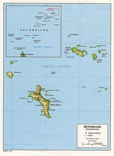
Map 1
-
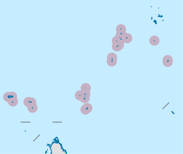
District Map
-
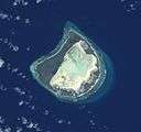
Astove Atoll, slightly oblique view from space.
Note the wide land area (dark) surrounding the whitish lagoon -

Aerial view
Further reading
- Stirling, William (1843, 223 pages). Narrative of the Wreck of the Ship Tiger, of Liverpool, (Captain Edward Searight), on the Desert Island of Astove, on the Morning of the 12th of August 1836 ... Roberts, London. Check date values in:
|date=(help)
- Travis, William (1959). Beyond the Reefs. George Allen & Unwin Ltd., London.
- Travis, William (1961). Shark for Sale. Rand McNally.
- Veevers-Carter, Wendy (1971). Island Home. Robert Hale Ltd. ISBN 0-7091-2772-3.
External links
- Island guide 1
- National Bureau of Statistics
- 2010 Sailing directions
- Piggott, C.J. (1961): Notes on some of the Seychelles Islands, Indian Ocean. Atoll Research Bulletin 83: 1–10. PDF fulltext
References
- ↑ History
- 1 2 A Brief History: Shipwrecks of the Seychelles, Glynn Burridge
- ↑ Island Home, by Wendy Veevers-Carter. Pub. Robert Hale Ltd, Nov. 11, 1971, 352 pages. ISBN 0-7091-2772-3
- ↑ My Life as Mrs. Robinson Crusoe, by Wendy Veevers-Carter, Parade, June 8, 1969, pages 6–7
- ↑ Mrs. Carter Learns She's a Widow, Lowell Sunday Sun(Massachusetts), March 22, 1970, pg. E4
- ↑ (15 March 1971). Dream of Life on Tropical Isle Becomes Reality, Oxnard Press-Courier (Associated Press story)
- ↑ Astove piracy
- ↑ Island info
- ↑ Official island info
- 1 2 3 4 5 6 Piggott (1961)
- ↑ ICS official site
- ↑ District map
- ↑ Radar near the airport now functional
- ↑ IDC official site
- ↑ Lodge info 1
- ↑ Lodge info 2
- ↑ Lodge info 3
- ↑ Lodge info 4
- ↑ Lodge info 5
- ↑ News
- ↑ News
- ↑ development plans
Outer islands of Seychelles / Coralline Seychelles (Zil Elwannyen Sesel) | |||||||||||||||||||
|---|---|---|---|---|---|---|---|---|---|---|---|---|---|---|---|---|---|---|---|
| Outer island Groups |  | ||||||||||||||||||
| Islands and Atolls |
| ||||||||||||||||||
| Wikimedia Commons has media related to Astove Island. |