Assumption Island
| Nickname: Île de l'Assomption | |
|---|---|
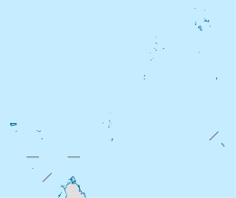 Assumption Island Location of Assumption Island in Seychelles | |
| Geography | |
| Location | Indian Ocean |
| Coordinates | 09°45′S 46°29′E / 9.750°S 46.483°ECoordinates: 09°45′S 46°29′E / 9.750°S 46.483°E |
| Archipelago | Seychelles |
| Adjacent bodies of water | Indian Ocean |
| Total islands | 1 |
| Major islands |
|
| Area | 11.60 km2 (4.48 sq mi) |
| Length | 6.7 km (4.16 mi) |
| Width | 2.9 km (1.8 mi) |
| Coastline | 17.23 km (10.706 mi) |
| Highest elevation | 32 m (105 ft) |
| Highest point | southeast hill |
| Administration | |
| Group | Outer Islands |
| Sub-Group | Aldabra Group |
| Districts | Outer Islands District |
Largest settlement |
Assumption (population 20) |
| Demographics | |
| Demonym | Creole |
| Population | 20 (2016) |
| Pop. density | 1.7 /km2 (4.4 /sq mi) |
| Ethnic groups | Creole, French, East Africans, Indians. |
| Additional information | |
| Time zone | |
| Official website |
www |
| ISO Code = SC-26 | |
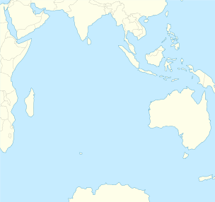
Assumption Island is a small island in the Outer Islands of Seychelles north of Madagascar, with a distance of 1,135 km (705 mi) southwest of the capital, Victoria, on Mahé Island. The island is leased to India.[1]
History
Assumption Island was discovered by Captain Nicolas Morphey on 14 August 1756, and was named after the religious feast of the next day. In 1908, the island was leased to Mr H. Savy of Mahé, who built a coconut plantation on the island. The first settlement was in the northern part of the island.[2] During a visit 2 years later, he realized the guano potential of the island. The villagers transferred their labor force to guano mining camp, that operated until 1983. The camp was the location of the current village. After that, the villagers were employed as fishermen, usually of bêche-de-mer, until it was declared protected. In the mid 1960s the island was proposed as an American military base, including a deep sea port. After strong protests from environmental organizations, this plan was rejected. In 1990 The airfield was built.[3] In 2015, India leased the island from the Seychelles.[1] The President of Seychelles confirmed that India is building a base for the Indian armed forces on the island, and as a listening and surveillance post.
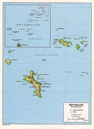
Geography
Assumption Island is located about 27 km south of Anse Takamaka on Aldabra Atoll and is part of the Aldabra Group. It is a single coral island which measures 11.6 km2 (4.5 sq mi) in area. The western shore features an almost uninterrupted sandy beach of 5.5 km. Two large sand dunes are prominent on the southeastern coast of the island, one of them 32 metres (105 ft) high.[4] The 5.5 km, white, sandy beach that stretches on the southeastern side of the island has been several times named 'the best beach in the world' for its white sand, crystalline waters, diversity of marine life and, due to its remote location, lack of crowds (or in fact, any people at all). Due to the disruptive effect of guano mining which lasted until 1983, the island is dominated by expanses of bare rock and caves, and is sparsely covered with low-growing vegetation.
Demographics
Assumption Island has a small village, with about 20 people, on the sheltered western side, surrounded by Casuarina trees. An abandoned coconut palm plantation is just south of it. The island has a construction camp with about 50 people at the southern point of the airfield. All labor are from India.
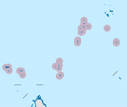
Administration
The island belongs to Outer Islands District, although it might be considered as part of the newly formed IIOT.[5] The small population on the island receive all of their services from the India army base at the southern part of the island. For governmental services, they have to go to Victoria, which is a difficult task.
Transport
The island is bisected by a 1,210 metres (3,970 ft) concrete airfield (ICAO: FSAS) that runs from between the two sand dunes on the southeast point to the village on the western coast. The island is occasionally serviced by an Island Development Company (IDC) aircraft from Mahé,[6] usually with scientists which have a boat take them to Aldabra Atoll.[7] The island has a small port called St. Thomas Anchorage, which is currently enlarged by the Indian army to a large port.[8]
Economics
The inhabitants on the island are engaged in very small scale farming and fishing which are mainly for the island consumption, and also work at the coast guard station near the village.
Military
| Indian Navy Assumption base | |||||||||||
|---|---|---|---|---|---|---|---|---|---|---|---|
|
Assumption base Location of Assumption base | |||||||||||
| IATA: none – ICAO: FSAS | |||||||||||
| Summary | |||||||||||
| Airport type | Indian Navy base | ||||||||||
| Owner | India | ||||||||||
| Operator | India | ||||||||||
| Location | Assumption Island, Seychelles | ||||||||||
| Built | 1989–1990; Major extensions 2015–2016 | ||||||||||
| In use | 1990–present | ||||||||||
| Elevation AMSL | ft / 3 m | ||||||||||
| Coordinates | 9°44′05″S 46°30′01″E / 9.73472°S 46.50028°E | ||||||||||
| Map | |||||||||||
 Assumption base Location of Assumption base in the Indian Ocean | |||||||||||
| Runways | |||||||||||
| |||||||||||
India has a military base on the island, and most of the population is composed of military personnel and supporting contractors. It includes both an air and naval base[9] and is located 3,915 km (2,433 mi) south-southwest of the southern tip of India (at Kanyakumari) is their first establishment on Seychelles and is a flexible forward hub that can facilitate a range of regional strategies. Local time is UTC+05:30 as is in Indiayear-round (DST is not observed).[10] To the Indian government, Assumption Island was a prime territory for setting up a foreign military base. it is located far away from any potential threats, and is nearly uninhabited. The 7 villagers were given an option to stay on the island with restrictions or to be transferred to Astove Island, where the Indian government built 2 residential houses as per their agreement with Seychelles. By 2018, construction of all of the military buildings should be completed.
- Naval Communication Station
A Base for Naval Communication was built in 2016[11][12]
- Renovated airfield
In August 2015, India Army construction battalions arrived on Assumption to begin the construction of the communications station and to enlarge the airfield.[13]
- Navy anchorage
The Indian government was given permission to dredge sand and build a new port instead of the ruined jetty on the island.[14][15][16] The goal is to have a deep-water pier, port facilities, maintenance buildings, terminal, clinic, fuel storage area, and billeting and messing facility for their personnel.
Image gallery
-

Indian naval bases, Seychelles included
-
.jpg)
Guard ceremony
-

Indian Navy Buoy
-
.jpg)
Indian Coast Guard manning the new Radar station
-

Vice Admiral B Verma with Commodore PK Bahl, CO Rajali and Commander HS Jhajj
Tourism
The island was a popular cruise stop due to its long jetty, and the numbers of arrivals were maintained by the Seychelles, until the lease to India took place which closed the island to the public.
Flora and fauna
Assumption Island was once home to a great diversity of seabirds, including the Abbott's booby,[17] which is now confined to a single breeding island: Christmas Island, in the eastern Indian Ocean. Efforts are now underway by the Seychelles Islands Foundation, in conjunction with Island Conservation Society and the Islands Development Company, to restore the habitat of the island. The first successful step in this process was the removal of invasive, introduced bird species, Madagascar fody and red-whiskered bulbul.[18] A notable feature of this island is the Assumption Island day gecko, a subspecies of gecko found only on this island. An endemic race of souimanga sunbird once breaded on the island, called Abbott's Booby.[19] The nature documentary of Jacques-Yves Cousteau and Louis Malle, The Silent World was partially shot on Assumption.[20] The island is known for its rich fish life.
Image gallery
-
Map 1
-
District Map
-
.jpg)
Assumption Island
-

Assumption Island with its runway
-

Assumption Island closer look
References
- 1 2 "India, Seychelles agree to lease Assumption Island for 'infrastructure development' – Latest News & Updates at Daily News & Analysis". 11 March 2015.
- ↑ Atoll research bulletin
- ↑ "Welcome to the Official Destination Website for the Seychelles Islands – Assumption".
- ↑ This sand dune is much lower today, as it is being dredged for the airport expansion by India and construction of the new naval base
- ↑ District map
- ↑ "Aldabra Atoll + Islands". 19 February 2013.
- ↑ "Seychelles Islands Foundation".
- ↑ Port info
- ↑ "Asia's scramble for Africa" – via The Economist.
- ↑ "World Time Chart" (PDF). US Navy. Retrieved 2012-08-07.
- ↑ "New coastal radar system means better safeguards for Seychelles, official says".
- ↑ Article 03.2016
- ↑ IANS. "India begins infrastructure work on Assumption Island of Seychelles".
- ↑ "Seychelles allows India to build Naval Base on its Assumption Island".
- ↑ "'Seychelles committed to Indian naval base'". 23 December 2015 – via The Hindu.
- ↑ "India to form its first Naval Base in Seychelles to tighten vigil over Indian Ocean: Read to know more : Current Affairs".
- ↑ Administrator, IDC. "Flora and Fauna – Assumption Island".
- ↑ "Eradication success – Seychelles wins war against invasive red-whiskered bulbul".
- ↑ "Other outer islands".
- ↑ Island guide
External links
| Wikimedia Commons has media related to Assumption Island. |
Outer islands of Seychelles / Coralline Seychelles (Zil Elwannyen Sesel) | |||||||||||||||||||
|---|---|---|---|---|---|---|---|---|---|---|---|---|---|---|---|---|---|---|---|
| Outer island Groups |  | ||||||||||||||||||
| Islands and Atolls |
| ||||||||||||||||||