Assiniboine River
| Assiniboine River | |
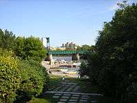
 A view of the Assiniboine River looking southeast from the Maryland Bridge in Winnipeg | |
| Country | Canada |
|---|---|
| Provinces | Saskatchewan, Manitoba |
| Part of | Red River drainage basin |
| Source | Windy Lake east of Kelvington |
| - location | Saskatchewan |
| - elevation | 640 m (2,100 ft) |
| - coordinates | CA 52°18′15″N 103°06′01″W / 52.30417°N 103.10028°W |
| Mouth | Red River of the North |
| - location | The Forks in Winnipeg, Manitoba |
| - elevation | 230 m (755 ft) |
| - coordinates | CA 49°53′09″N 97°07′44″W / 49.88583°N 97.12889°WCoordinates: CA 49°53′09″N 97°07′44″W / 49.88583°N 97.12889°W |
| Length | 1,070 km (665 mi) |
| Basin | 182,000 km2 (70,271 sq mi) |
| Discharge | |
| - average | 45 m3/s (1,589 cu ft/s) |
 Red River drainage basin, with the Assiniboine River highlighted
| |
| [1][2] | |
The Assiniboine River (/əˈsɪnᵻbɔɪn/) is a 1,070-kilometre (660 mi) river that runs through the prairies of Western Canada in Saskatchewan and Manitoba. It is a tributary of the Red River. The Assiniboine is a typical meandering river with a single main channel embanked within a flat, shallow valley in some places and a steep valley in others. Its main tributaries are the Qu'Appelle, Souris and Whitesand Rivers. For early history and exploration see Assiniboine River fur trade.
The river takes its name from the Assiniboine First Nation. Robert Douglas of the Geographical Board of Canada (1933) made several comments as to its origin: "The name commemorates the Assiniboine natives called by La Vérendrye in 1730 'Assiniboils' and by Governor Knight in 1715 of the Hudson's Bay Company 'stone Indians.' Assiniboine is the name of a First Nation and is derived from the Ojibwe words 'asin' a stone and 'bwaan' the Sioux, hence Stony Sioux name was possibly given because they used heated stones in cooking their food."[3]
Course
The Assiniboine River rises in eastern Saskatchewan east of the community of Kelvington on the upper prairie level above the Manitoba Escarpment. The Assiniboine River flows through three basic zones with different channel characteristics. Upstream of Brandon, the main stem of the river and its most important tributaries flow within a very large valley. The valley was cut by huge glacial melt water flows at the end of the last glaciation. The floor of this spillway valley provides a natural floodplain for the river and the valley provides a significant storage volume making the construction of the Shellmouth Dam near Russell both technically and economically viable. The major tributaries in this reach are the Qu’Appelle, Shell and Little Saskatchewan Rivers.
The glacial flows created a large delta east of Brandon extending almost to Portage la Prairie. The river has eroded down through sediments of the delta cutting a narrow valley through these sediments as it drops through a vertical distance of about 150 metres (490 ft) to the Lake Agassiz – Red River Plain . In this valley, the river is confined with a narrow valley floor. The Souris River is the primary tributary contributing flow to the Assiniboine in this reach. Near Portage la Prairie the river emerges from the delta reach onto the relatively flat Red River plain (the floor of former Glacial Lake Agassiz) and at this point it can flow in any direction from roughly northwest to roughly southeast. The gradient of the river channel within the delta reach to the west is relatively high, so the river water velocities are fairly high and the waters of the river carry significant amounts of sediment. The gradient in the flat Red River plain is much less and the velocity of the river water flowing over this plain is much lower. Therefore, the sediments carried by the river waters as they flow through the delta reach are deposited onto the plain. The Assiniboine winds its way east eventually joining the Red River at "The Forks" in Winnipeg, Manitoba.
Today, Assiniboine Herald at the Canadian Heraldic Authority is named after the river. Asessippi Provincial Park, an RV park was built on the east shore of the Shellmouth Reservoir.
Tributaries include the Whitesand River which joins it near Kamsack, Saskatchewan, the Souris River, which joins it near Wawanesa, Manitoba, the Birdtail River which joins at the Birdtail Sioux First Nation, the Little Saskatchewan, which joins west of Brandon, and the Qu'Appelle River, which joins near the site of the Hudson's Bay Company historic Fort Ellice site.
Flow rates and flood potential

There are three hydrometric stations on the river that have been taking measurements since 1913. The Assiniboine River near Headingley has an average discharge of 45 cubic metres per second (1,600 cu ft/s).[4] One millimeter of runoff from half the watershed would take 70 hours to drain at flow rates of 360 cubic metres per second (13,000 cu ft/s). The following discharge rates were recorded during the 1995 flood:[5]
| Location | Peak flow, 1995 (m3/s) |
Mean flow, April '95 (m3/s) |
Mean flow, May '95 (m3/s) |
Max flow, date (m3/s) |
|---|---|---|---|---|
| Russell | 360 May 4 |
34.2 | 46.3 | 504 April 29, 1922 |
| Brandon | 566 April 26 |
81.1 | 104.0 | 651 May 7, 1923 |
| Headingley | 300 April 20 |
115.0 | 142.0 | 614 April 27, 1916 |
It is prone to spring flooding. Some flood flows can be diverted into Lake Manitoba at Portage la Prairie. In 1967, the Shellmouth Dam was built in Shellmouth to help reduce flood peaks and to supplement flows during dry periods. The Portage Diversion was completed in 1970. Despite these efforts, in May 2011 it was necessary to breech one of the dikes beside the river to relieve flood stresses east of Portage la Prairie. A Manitoba-wide state of emergency was declared in the wake of one in three hundred-year floods on the Assiniboine River at Brandon.[6][7][8]
| Location | 1882 Peak Flow (cfs) (Estimated) [9] | 1976 Peak Flow (cfs) [10] | 2011 Peak Flow (cfs) [9] | 2014 Peak Flow (cfs) [11][12] |
|---|---|---|---|---|
| Brandon | 43,000 | 21,700 | 36,700 | 38,870 |
| Portage la Prairie | N/A | 49,000 | 53,100 | 52,100 |
| Headingley | 32,000 | 21,700 | 19,200 | TBD |
- Note: Flows in 1882 occurred before any flood protection measures such as the Shellmouth Reservoir and Portage Diversion were built.
Fauna
Fish species include walleye, yellow perch, northern pike, mooneye, burbot, channel catfish brown bullhead, rock bass, white sucker, shorthead redhorse and common carp.
See also
References
- ↑ "Natural Resources Canada-Canadian Geographical Names (Assiniboine River)". Retrieved 2014-08-29.
- ↑ "Atlas of Canada Toporama". Retrieved 2014-08-29.
- ↑ R. Douglas, Place names of Manitoba, Geographic Board of Canada, Department of Interior, Canada, 1933
- ↑ Atlas of Canada. "Rivers of Canada". Archived from the original on January 25, 2008. Retrieved 2008-02-15.
- ↑ Natural Resources Canada. "The Assiniboine River bursts its banks". Archived from the original on 3 February 2008. Retrieved 2008-02-15.
- ↑ (CTV)
- ↑ (The Canadian Press)
- ↑ (CJOB 68) Archived March 31, 2012, at the Wayback Machine.
- 1 2 "2011 Flood: Technical Review of Lake Manitoba, Lake St. Martin and Assiniboine River Water Levels" (PDF). Province of Manitoba. October 2013. p. 25. Retrieved July 25, 2015.
- ↑ "Daily Water Levels and Forecasts Assiniboine River June 22, 2012" (PDF). Province of Manitoba. 2012. Retrieved July 25, 2015.
- ↑ "Summer Flood Bulletin #15". Province of Manitoba. July 10, 2014.
- ↑ "Flood Report For Manitoba - July 12, 2014" (PDF). Province of Manitoba. July 12, 2014.