Ashland, New Hampshire
| Ashland, New Hampshire | |
|---|---|
| Town | |
 | |
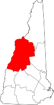
 Location in Grafton County, New Hampshire | |
| Coordinates: 43°41′42″N 71°37′54″W / 43.69500°N 71.63167°WCoordinates: 43°41′42″N 71°37′54″W / 43.69500°N 71.63167°W | |
| Country | United States |
| State | New Hampshire |
| County | Grafton |
| Incorporated | 1868 |
| Government | |
| • Board of Selectmen |
Frances Newton, Chair Steve Felton Harold Lamos Leigh Sharps |
| • Town Administrator | Charlie Smith |
| Area | |
| • Total | 11.5 sq mi (29.8 km2) |
| • Land | 11.0 sq mi (28.5 km2) |
| • Water | 0.5 sq mi (1.4 km2) 4.62% |
| Elevation | 558 ft (170 m) |
| Population (2010) | |
| • Total | 2,076 |
| • Density | 180/sq mi (70/km2) |
| Time zone | Eastern (UTC-5) |
| • Summer (DST) | Eastern (UTC-4) |
| ZIP code | 03217 |
| Area code(s) | 603 |
| FIPS code | 33-02020 |
| GNIS feature ID | 0873534 |
| Website |
www |
Ashland is a town in Grafton County, New Hampshire, United States. The population was 2,076 at the 2010 census.[1] Located near the geographical center of the state, Ashland is home to Scribner-Fellows State Forest.
The main village of the town, where 1,244 people resided at the 2010 census,[1] is defined as the Ashland census-designated place (CDP), and is located at the junction of U.S. Route 3 and New Hampshire Route 25 with NH Route 132.
History
Ashland was once the southwestern corner of Holderness, chartered in 1751 by Colonial Governor Benning Wentworth. But hostilities during the French and Indian War delayed settlement, and in 1761, it was regranted as New Holderness (although "New" would be dropped in 1816). Settled in 1763, the town was predominantly agricultural except for Holderness Village on the Squam River, with falls that drop about 112 feet (34 m) before meeting the Pemigewasset River. The falls provided water power for mills, and in 1770-1771, a sawmill and gristmill were built. The Squam Lake Woolen Mill was established in 1840. Goods manufactured at local factories included hosiery, gloves, sporting equipment, wood products and paper.[2]
The Boston, Concord & Montreal Railroad[3] entered in 1849, carrying freight but also tourists bound for hotels on the Squam Lakes, to which they traveled by steamer up the Squam River. The interests of the industrialized settlement increasingly diverged from those of the farming community, however, and in 1868 Holderness Village was set off as Ashland, named for Ashland, the Kentucky estate of Henry Clay. The last textile mill, the L.W. Packard Company, would close in 2002, and Ashland is today a residential and resort community.[4]
-
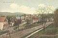
Downtown c. 1912
-

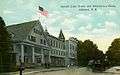
View of Town Hall c. 1910
-

Mill dam c. 1910
-
View of the mills c. 1908
Geography
According to the United States Census Bureau, the town has a total area of 11.5 square miles (29.8 km2), of which 11.0 square miles (28.5 km2) is land and 0.5 square miles (1.3 km2) is water, comprising 4.62% of the town.[5] Bounded on the west by the Pemigewasset River, Ashland is drained by the Squam River and Owl Brook. Little Squam Lake is on the eastern boundary. The highest point in Ashland is Hicks Hill, at 1,386 feet (422 m) above sea level. Ashland lies fully within the Merrimack River watershed.[6]
The town is served by Interstate 93, U.S. Route 3, and state routes 25, 132 and 175.
Demographics
| Historical population | |||
|---|---|---|---|
| Census | Pop. | %± | |
| 1870 | 885 | — | |
| 1880 | 960 | 8.5% | |
| 1890 | 1,193 | 24.3% | |
| 1900 | 1,289 | 8.0% | |
| 1910 | 1,412 | 9.5% | |
| 1920 | 1,325 | −6.2% | |
| 1930 | 1,375 | 3.8% | |
| 1940 | 1,460 | 6.2% | |
| 1950 | 1,599 | 9.5% | |
| 1960 | 1,473 | −7.9% | |
| 1970 | 1,599 | 8.6% | |
| 1980 | 1,807 | 13.0% | |
| 1990 | 1,915 | 6.0% | |
| 2000 | 1,955 | 2.1% | |
| 2010 | 2,076 | 6.2% | |
| Est. 2015 | 2,058 | [7] | −0.9% |
As of the census[9] of 2000, there were 1,955 people, 853 households, and 515 families residing in the town. The population density was 173.7 people per square mile (67.1/km²). There were 1,149 housing units at an average density of 102.1 per square mile (39.4/km²). The racial makeup of the town was 97.44% White, 0.36% African American, 0.26% Native American, 0.72% Asian, 0.26% from other races, and 0.97% from two or more races. Hispanic or Latino of any race were 0.77% of the population.
There were 853 households out of which 28.8% had children under the age of 18 living with them, 44.4% were married couples living together, 11.6% had a female householder with no husband present, and 39.6% were non-families. 31.1% of all households were made up of individuals and 9.7% had someone living alone who was 65 years of age or older. The average household size was 2.29 and the average family size was 2.85.
In the town the population was spread out with 23.4% under the age of 18, 10.2% from 18 to 24, 30.0% from 25 to 44, 22.7% from 45 to 64, and 13.6% who were 65 years of age or older. The median age was 37 years. For every 100 females there were 91.5 males. For every 100 females age 18 and over, there were 89.5 males.
The median income for a household in the town was $33,345, and the median income for a family was $38,487. Males had a median income of $29,630 versus $23,242 for females. The per capita income for the town was $17,450. About 7.5% of families and 10.2% of the population were below the poverty line, including 10.0% of those under age 18 and 8.7% of those age 65 or over.
Sites of interest
- Ashland Train Depot (c. 1869, 1891)
- Pauline E. Glidden Toy Museum (c. 1810)
- Whipple House Museum (1837)
- St. Mark's Episcopal Church, 1899
Notable people
- James F. Briggs, US congressman
- Moses Cheney, abolitionist; member of the Underground Railroad
- Oren B. Cheney, founder of Bates College
- Person C. Cheney, US senator and the 43rd governor of New Hampshire
- George Hoyt Whipple, pathologist; Nobel Prize winner
References
- 1 2 United States Census Bureau, American FactFinder, 2010 Census figures. Retrieved March 23, 2011.
- ↑ Coolidge, Austin J.; John B. Mansfield (1859). A History and Description of New England. Boston, Massachusetts. pp. 529–530.
- ↑ Article in Statistics and Gazetteer of New-Hampshire (1875)
- ↑ History of Ashland, New Hampshire
- ↑ "Geographic Identifiers: 2010 Demographic Profile Data (G001) - Ashland town, New Hampshire". U.S. Census Bureau American Factfinder. Archived from the original on September 11, 2013. Retrieved November 10, 2011.
- ↑ Foster, Debra H.; Batorfalvy, Tatianna N.; Medalie, Laura (1995). Water Use in New Hampshire: An Activities Guide for Teachers. U.S. Department of the Interior and U.S. Geological Survey.
- ↑ "Annual Estimates of the Resident Population for Incorporated Places: April 1, 2010 to July 1, 2015". Retrieved July 2, 2016.
- ↑ "Census of Population and Housing". Census.gov. Archived from the original on May 11, 2015. Retrieved June 4, 2016.
- ↑ "American FactFinder". United States Census Bureau. Archived from the original on 2013-09-11. Retrieved 2008-01-31.
External links
| Wikivoyage has a travel guide for Ashland (New Hampshire). |
- Town of Ashland official website
- Ashland Town Library
- New Hampshire Economic and Labor Market Information Bureau Profile