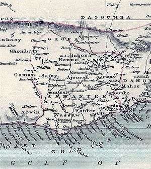
Ashantiland
Ashantiland (Ashanti: Asanteman), formerly known as the Ashanti Empire, is an unused term which covers the former homeland of the Ashanti people in Ghana and parts of Côte d'Ivoire. The territory, located in southern Ghana, is bounded by the Black Volta River to the north, Lake Volta to the east, the Pra and Offin river to the south, and Ivory Coast to the west. It is a non-governmental cultural and linguistic area defined by the Ashanti traditions and language. The territory comprises parts of six modern day regions in Ghana: the Ashanti Region, the Brong-Ahafo Region, the Central Region, parts of Eastern Region, and parts of Greater Accra Region, and the Western Region.[1]
Etymology
"Ashantiland" is a translation of the Ashanti term Asanteman.[2] The word man, which forms the second element of the expression, has a meaning similar to "community", "nation", or "state".[2]
History
Bonoman (500–1400)
Bonoman, or Bono State, was a trading state created by the Akan people in the 11th century, following the establishment of a settlement in the 6th century. It was located in modern Brong-Ahafo Region and parts of eastern Ivory Coast,[3] is generally accepted as the origin of subgroups of the Akan people who migrated at various points in search of gold and created new settlements.[3] The gold trade, which started to boom in Bonoman as early as the 12th century, was the source of Akan power and wealth in the region, beginning in the Middle Ages.[3][4] Various aspects of Akan culture stem from Bonoman, including the swords (Akrafena) of the Ashanti nation, the Golden Stool, goldsmithing, blacksmithing, kente cloth, gold weighing, and the umbrella used by kings.[5]
All Akan offshoots—including the Denkyira (further divided into the Assin, Fante Confederacy, and Mankessim Kingdom), Akyem (divided into the Akwamu, Akuapem, and Kwahu), and Ahanta (divided into the Aowin, Sefwi, and Wassa)—originated in Bono State.[6]
Gyaaman and Denkyira (1400–1600)
Gyaaman (also spelled Jamang) was a medieval state founded by the Ashanti in 1450, mostly in what is now Brong-Ahafo. Denkyira was founded in 1620 in what are now the Central and Western regions.
During the 16th century, the Ashanti society experienced sudden changes, including population growth, because of the cultivation of New World plants such as cassava and maize and an increase in the gold trade between coastal and northern areas.[7]
Kingdom of Ashanti (1670–1902)
By the 17th century, a segment of the Akan people were living in a state called Kwaaman, north of Lake Bosomtwe.[7] The state's revenue was mainly derived from a trade in gold, kola nuts, and cocoa, and from clearing forested areas to plant yams.[7] The Akans built towns between the Pra and Ofin rivers.[7] They formed alliances for defense and paid tribute to Denkyira, one of the more powerful Akan settlement states at that time, along with Adansi and Akwamu.[7]
King Osei Kofi Tutu I (c. 1695–1717), aided by an Akwamu sorcerer, Okomfo Anokye, unified what would become the Kingdom of Ashanti, with the Ashanti royal throne, the Golden Stool, as a symbol of the people's unity and spirit.[8] He engaged in a massive territorial expansion,[8] building an army based on that of the Akwamu settlement and turning a disciplined militia into an effective fighting machine.[8] In 1701, the kingdom conquered Denkyira, giving the Ashanti access to the coastal trade with Europe, especially the Dutch Republic.[8]
King Opoku Ware I (1720–1745) engaged in further expansion, adding more southern settlements to the growing empire.[8] He then turned north, adding Techiman, Banda, Gyaaman, and Gonja on the Black Volta.[8] In 1744 and 1745, he attacked the Kingdom of Dagbon, a northern state of the Dagomba people, gaining control of the important middle Niger trade routes.[8] King Kusi Obodom (1750–1764) solidified the newly won territories.[8]
King Osei Kwadwo (1764–1777) imposed administrative reforms that allowed the empire to be governed effectively and to continue its military expansion.[8] King Osei Kwame Panyin (1777–1803), King Osei Tutu Kwame (1804–1807), and King Osei Bonsu (1807–1824) continued Ashanti territorial consolidation and expansion.[8] The empire grew to include all of present-day Ghana and large parts of the southeastern Ivory Coast.[8] Throughout the 19th century, the Ashanti remained powerful.[9] The empire was subjugated by the British Gold Coast in 1902, after the four Anglo-Ashanti wars and the War of the Golden Stool.[9]
Territorial borders
 |
Black Volta River | | ||
| |
|
Lake Volta | ||
| ||||
| | ||||
| Atlantic Ocean | Gulf of Guinea and Atlantic Ocean | Lake Volta and Gulf of Guinea |
See also
| Wikimedia Commons has media related to Ashanti peoplpe. |
| Wikimedia Commons has media related to Ashanti Empire. |
- List of rulers of Asante
- Ashanti people
- Ashanti language
- Ashanti Empire
- Battle of Feyiase
- Anglo-Ashanti wars
- War of the Golden Stool
- Golden Stool
- Akwasidae Festival
- Adae Festival
- Adae Kese Festival
- Awukudae Festival
- Ashanti Yam Festival
- Kwame Nkrumah University of Science and Technology
- Asante Kotoko SC
- Ashanti Gold SC
- King Faisal Babies FC
- New Edubiase United
- Kumasi Sports Stadium
- Ashanti Region
- Obuasi Gold Mine
- Iduapriem Gold Mine
- Chirano Gold Mine
- Damang Mine
- Ahafo Mine
- Tarkwa Mine
- List of Akan people
References
- ↑ "History of the Asante (Ashanti) People" (PDF). anglogold.com. Retrieved 23 January 2015.
- 1 2 Transactions of the Historical Society of Ghana, Volumes 7–9, p. 28
- 1 2 3 Djibril Tamsir Niane, Africa from the Twelfth to the Sixteenth Century, UNESCO. International Scientific Committee for the Drafting of a General History of Africa.
- ↑ Effah-Gyamfi, Kwaku (1987). "Archaeology and the study of early African towns: the West African case, especially Ghana", West African Journal of Archaeology.
- ↑ Kwasi Konadu, Indigenous Medicine and Knowledge in African Society, Routledge, 2007.
- ↑ Shmuel Noah Eisenstadt; Michel Abitbol; Naomi Chazan (1988). The Early State in African Perspective: Culture, Power and Division of Labor. Brill Academic Publishers. ISBN 90-04-08355-3.
- 1 2 3 4 5 Collins and Burns (2007), p. 139.
- 1 2 3 4 5 6 7 8 9 10 11 Collins and Burns (2007), p. 140.
- 1 2 Davidson (1991), p. 242.
Ashanti articles | ||||||||
|---|---|---|---|---|---|---|---|---|
| History |
|  | ||||||
| Geography |
| |||||||
| Politics |
| |||||||
| Economy | ||||||||
| Society |
| |||||||
Akan topics | |||||||||||||||
|---|---|---|---|---|---|---|---|---|---|---|---|---|---|---|---|
| History | |||||||||||||||
| Demographics |
| ||||||||||||||
| Subgroups | |||||||||||||||
| Linguistics (language) | |||||||||||||||
| Politics |
| ||||||||||||||
| Culture |
| ||||||||||||||
| Geography (Ashantiland Peninsula) |
| ||||||||||||||
| Wikipedia | |||||||||||||||
Coordinates: 5°27′N 0°58′W / 5.450°N 0.967°W