Asasp-Arros
| Asasp-Arros | |
|---|---|
 | |
 Asasp-Arros | |
|
Location within Nouvelle-Aquitaine region  Asasp-Arros | |
| Coordinates: 43°07′24″N 0°36′45″W / 43.1233°N 0.6125°WCoordinates: 43°07′24″N 0°36′45″W / 43.1233°N 0.6125°W | |
| Country | France |
| Region | Nouvelle-Aquitaine |
| Department | Pyrénées-Atlantiques |
| Arrondissement | Oloron-Sainte-Marie |
| Canton | Oloron-Sainte-Marie-Ouest |
| Intercommunality | Piémont Oloronais |
| Government | |
| • Mayor (2014–2020) | Bernard Mora |
| Area1 | 23.59 km2 (9.11 sq mi) |
| Population (2010)2 | 505 |
| • Density | 21/km2 (55/sq mi) |
| Time zone | CET (UTC+1) |
| • Summer (DST) | CEST (UTC+2) |
| INSEE/Postal code | 64064 / 64660 |
| Elevation |
243–1,093 m (797–3,586 ft) (avg. 300 m or 980 ft) |
|
1 French Land Register data, which excludes lakes, ponds, glaciers > 1 km² (0.386 sq mi or 247 acres) and river estuaries. 2 Population without double counting: residents of multiple communes (e.g., students and military personnel) only counted once. | |
Asasp-Arros (Occitan: Asasp Arròs) is a French commune in the Pyrénées-Atlantiques department in the Nouvelle-Aquitaine region of south-western France.
The inhabitants of the commune are known as Asaspois or Asaspoises.[1]
Geography

_la_Toupiette.JPG)
_moument_aux_morts.JPG)
_Gave_d'Aspe_%C3%A0_Asasp.JPG)
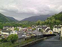
Asasp-Arros is located 6 km south of Oloron-Sainte-Marie on the left bank of the Gave d'Aspe and straddling the old royal route built by Louis XIV to Canfranc in Spain.[2] The commune consists of two portions joined by a narrow neck of land just south-west of Lurbe-Saint-Christau. Access to the commune is by Route nationale N134 (European route E7) from Gurmençon in the north passing through the length of the commune and the village and continuing to Sarrance in the south. The D918 road comes from Issor in the west then goes east from the village over the mountains to Arudy. The southern portion of the commune is heavily forested with few farms while the northern also has extensive forests but with about 40% of the land area farmland.[3]
_confluence_Gave_de_Lourdios_-_Gave_d'Aspe.JPG)
The commune is part of the Drainage basin of the Adour with the Gave d'Aspe forming its entire eastern border as it flows north to join the Gave d'Oloron at Oloron-Sainte-Marie. Many tributaries flow into the Gave d'Aspe in the commune. From south to north these are: the Soum de Bordettes, the Ruisseau des Cournales, the Ruisseau de Labatnere, the Gave de Lourdios at the neck of the commune, and the Ruisseau Toupiette. In the west of the commune the Mielle river flows north with several tributaries rising in the commune: the Arrec de Bernet, the Arrec de Termy, the Arrec de Cazaux, and the Arrec de Sarraude. The Mielle continues north to join the Gave d'Oloron south-east of Moumour.[3]
Places and Hamlets[4]
- Arenguet
- Arripe[5]
- Arros
- Asasp
- Athay (rock)
- Auquis
- Ayestène
- Bellevue
- Bernet
- Bordis
- Boumayou[6]
- Bourderot (Mill)
- La Bourdette
- Bourdette (Soum des)
- Cambet (Pass - 578 metres)
- Carrère
- Casaudoumecq
- Castets
- Cazaux
- Chichet
- Cousté
- Croharé
- Esparbé (Talou of)
- Estrabeau
- Feugas
- Fouistou
- Garay (Forest)
- Gouadain
- Granet
- Hourc-Gros[7]
- Les Indes
- Jeannot
- Jean-Petit
- Juncas
- Labatnère
- Laborde
- Lacabe
- Lacanette (fountain)
- Le Lagnos[8]
- Lalanne
- Lalanne (calvary)
- Lassalette de l'Arrayous
- Lestelle
- Les Louzères
- Magendie
- Maunas
- Minvielle
- Mirandette
- Monlong[9]
- Le Pacq
- Payssas
- Perte
- Peyre
- Poey
- Pucheu
- Ségu[10]
- Serrelongue (Forest)
- Serre-Sècque (Pass - 509 metres)
- Soum Artigue
- Tachouas[11]
- Termy (Forest)
Neighbouring communes and villages[3]
 |
Ance | Agnos | Eysus | |
| Aramits | |
Arudy | ||
| ||||
| | ||||
| Issor | Sarrance | Lurbe-Saint-Christau |
Toponymy
The name Asasp appears in the forms:
- Asap (1364,[12] Fors de Béarn[13]),
- Azasp (1375,[12] Contracts of Luntz[14]),
- Asasp (around 1630,[15] by Pierre de Marca, History of Béarn), and
- Asasp on the Cassini Map in 1750[16]
Michel Grosclaude[15] indicated that Asasp is related to the basque as/aitz ("rocky point") and aspi ("Behind"), giving "under the rocky point".
The name Arros is mentioned in the 12th century[17] (Titles of Gabas[18]) and also in:
- 1220[15] (For of Oloron,[13] on a copy of 1551),
- 1249[15] (sentence in the Josbaig, vidimus of 1464),
- 1367[15] (Cartulary of Oloron[19]),
- 1380[15] (Departmental archives of Pyrénées-Atlantiques), and
- 1750 on the Cassini Map.[16]
According to Michel Grosclaude,[15] Arros comes from the basque radical (h)arr ("stone") or from a former owner called Arro, in each of the two possibilities expanded by the Aquitaine suffix -ossum, giving "place of stone" or "Domain of Arro".
From 1956 until 1971 (the date of merging with Asasp) Arros was called Arros-d'Oloron[2] to differentiate it from Arros-de-Nay.
Its name in béarnais is Asasp-Arros.
Arripe is a farm in Asasp mentioned in 1385[5] (Census of Béarn[13]).
Attay is an area in Asasp cited in the dictionary of 1863.[20]
Boumayou is a hamlet referenced by the dictionary in 1863.[6]
Castetgouly[21] and Castetmans[21] were also places in Asasp.
Caup was another name mentioned in the dictionary in 1863.[22]
La Courtie was a place in Asasp cited by the dictionary in 1863.[23]
Croues, another area in Asasp, appears in the Terrier of Asasp,[24] in 1778 with the spelling Couroues.[23]
Domec was a fief, vassal of the Viscounts of Béarn, cited in 1863 [25] in the forms:
Hourcq was an area in Asasp in 1863.[7]
Le Lagnos is a forest in Asasp, which in 1538 was called Lo Lanhos (,[8] Reformation of Béarn[26]).
Monlong was referenced in 1863 as a moor in Asasp[9] as was Tachouas.[11]
Ségu is a mountain whose slopes are in both Asasp and Issor.[10]
History
Paul Raymond noted that in 1385 Asasp had 17 fires and Arros 7. Both depended on the bailiwick of Oloron.[12]
Arros commune had a Lay Abbey, vassal of the Viscounts of Béarn.[17]
On 1 January 1973 (Prefectorial Order of 29 December 1972),[2] the commune of Arros-d'Oloron (called Arros until 1956) was merged with Asasp to form the new commune of Asasp-Arros.
Administration
List of Successive Mayors[27]
| From | To | Name | Party | Position |
|---|---|---|---|---|
| 1995 | 2001 | Henri Navailles | ||
| 2001 | 2008 | Vincent Poey | ||
| 2008 | 2014 | André Minjuzan | ||
| 2014 | 2020 | Bernard Mora |
(Not all data is known)
Inter-communality
The commune is part of seven inter-communal structures:[28]
- the Community of communes of Piémont Oloronais;
- the Energy association of Pyrénées-Atlantiques;
- the association for the source of the Colombe;
- the educational regrouping association of the communes of Lurbe and Asasp-Arros;
- the television association of Oloron-Aspe Valley;
- the inter-communal association for sanitation of the gateway of the Aspe;
- the joint association for production of drinking water Jean Petit;
Demography
In 2010 the commune had 505 inhabitants. The evolution of the number of inhabitants is known from the population censuses conducted in the commune since 1793. From the 21st century, a census of communes with fewer than 10,000 inhabitants is held every five years, unlike larger towns that have a sample survey every year.[Note 1]
| 1793 | 1800 | 1806 | 1821 | 1831 | 1836 | 1841 | 1846 | 1851 |
|---|---|---|---|---|---|---|---|---|
| 602 | 517 | 611 | 563 | 713 | 751 | 766 | 718 | 741 |
| 1856 | 1861 | 1866 | 1872 | 1876 | 1881 | 1886 | 1891 | 1896 |
|---|---|---|---|---|---|---|---|---|
| 642 | 649 | 619 | 583 | 543 | 513 | 502 | 491 | 495 |
| 1901 | 1906 | 1911 | 1921 | 1926 | 1931 | 1936 | 1946 | 1954 |
|---|---|---|---|---|---|---|---|---|
| 465 | 511 | 560 | 489 | 438 | 482 | 421 | 407 | 431 |
| 1962 | 1968 | 1975 | 1982 | 1990 | 1999 | 2006 | 2010 | - |
|---|---|---|---|---|---|---|---|---|
| 434 | 395 | 566 | 564 | 601 | 547 | - | 505 | - |
Sources : Ldh/EHESS/Cassini until 1962, INSEE database from 1968 (population without double counting and municipal population from 2006)

Economy
The main activity is agriculture(livestock, pasturage, polyculture). The commune is in the Appellation d'origine contrôlée (AOC) zone of Ossau-iraty. The quality of the water from the rivers allows development of Fish farming.
A Hydro-electric power station has been built at the confluence of the Gave d'Aspe and the Gave de Lourdios.[2]
Culture and heritage
Civil heritage
Until 1494[2] there was a dyke on the gave d'Aspe which linked Lurbe to Asasp. It was then replaced with a bridge, making the village an important stage on a secondary way on the via Podiensis (or Puy Route), one of the modern paths on the Way of St. James.
Religious heritage
There are two churches in Asasp-Arros which are listed as historical monuments. These are:
- The Parish Church of Saint-Jean-l'Évangéliste at Asasp (19th century)
 .[29] The church has several items registered as historical objects:
Parish Church of Saint-Jean-l'Évangéliste
-

Road to the church
-

Outside view
-

The church approach
-
_monument_aux_morts_sur_le_mur_de_l'eglise.JPG)
War memorial plaque on the church
-
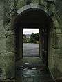
Entry to the Church

- The Parish Church of Saint-Vincent-Diacre at Arros (19th century).[34] The church has two items registered as historical objects:
Environmental heritage
A large wooded area,[37] with many hiking trails extends over the commune.
The peak of Bellevue, which is also called Cambet, is 681 metres high,[4] the summit of Caut is 689 metres,[4] the summit of Las Osques is 691 metres,[4] and Pédeher is 712 metres.[4] On the frontier with Issor the summit of Athay is 728 metres[4] high and that of Ségu is 768 metres.[4]
Facilities
Education
The commune has an Elementary school.
Sports
The Rugby union club (ASAAR) plays in the championship of France in the 2nd series.
See also
External links
- Commune website (French)
- Asasp-Arros on Géoportail, National Geographic Institute (IGN) website (French)
- Asasp and Arros on the 1750 Cassini Map
- Asasp-Arros on the INSEE website (French)
- INSEE (French)
Notes and references
Notes
- ↑ At the beginning of the 21st century, the methods of identification have been modified by Law No. 2002-276 of 27 February 2002, the so-called "law of local democracy" and in particular Title V "census operations" allows, after a transitional period running from 2004 to 2008, the annual publication of the legal population of the different French administrative districts. For communes with a population greater than 10,000 inhabitants, a sample survey is conducted annually, the entire territory of these communes is taken into account at the end of the period of five years. The first "legal population" after 1999 under this new law came into force on 1 January 2009 and was based on the census of 2006.
References
- ↑ Inhabitants of Pyrénées-Atlantiques (French)
- 1 2 3 4 5 History page on the commune website (French)
- 1 2 3 Google Maps
- 1 2 3 4 5 6 7 Géoportail, IGN (French)
- 1 2 Topographic Dictionary of the Department of Basses-Pyrenees, p. 12 (French)
- 1 2 Topographic Dictionary of the Department of Basses-Pyrenees, p. 35 (French)
- 1 2 Topographic Dictionary of the Department of Basses-Pyrenees, p. 80 (French)
- 1 2 Topographic Dictionary of the Department of Basses-Pyrenees, p. 90 (French)
- 1 2 Topographic Dictionary of the Department of Basses-Pyrenees, p. 116 (French)
- 1 2 Topographic Dictionary of the Department of Basses-Pyrenees, p. 159 (French)
- 1 2 Topographic Dictionary of the Department of Basses-Pyrenees, p. 165 (French)
- 1 2 3 Topographic Dictionary of the Department of Basses-Pyrenees, Paul Raymond, Imprimerie nationale, 1863, Digitised from Lyon Public Library 15 June 2011, p. 14 (French)
- 1 2 3 Manuscript from the 14th century - Departmental Archives of Pyrénées-Atlantiques (French)
- ↑ Contracts retained by Luntz, Notary of Béarn - Manuscript from the 14th century - Departmental Archives of Pyrénées-Atlantiques (French)
- 1 2 3 4 5 6 7 Michel Grosclaude, Toponymic Dictionary of communes, Béarn, Edicions reclams & Édition Cairn - 2006, 416 pages, ISBN 2 35068 005 3 (French)
- 1 2 Cassini Map 1750 - Asasp
- 1 2 Topographic Dictionary of the Department of Basses-Pyrenees, p. 13 (French)
- ↑ Titles of the hospital of Gabas - Departmental Archives of Pyrénées-Atlantiques (French)
- ↑ Titles published in the History of Béarn by Pierre de Marca
- ↑ Topographic Dictionary of the Department of Basses-Pyrenees, p. 16 (French)
- 1 2 Topographic Dictionary of the Department of Basses-Pyrenees, p. 46 (French)
- ↑ Topographic Dictionary of the Department of Basses-Pyrenees, p. 47 (French)
- 1 2 Topographic Dictionary of the Department of Basses-Pyrenees, p. 53 (French)
- ↑ Manuscript from the 18th century - Departmental Archives of Pyrénées-Atlantiques (French)
- 1 2 Topographic Dictionary of the Department of Basses-Pyrenees, p. 55 (French)
- 1 2 Manuscript from the 16th to 18th centuries - Departmental Archives of Pyrénées-Atlantiques (French)
- ↑ List of Mayors of France (French)
- ↑ Intercommunality of Pyrénées-Atlantiques, Cellule informatique préfecture 64, consulted on 2 March 2012 (French)
- ↑ Ministry of Culture, Mérimée IA64000616 Church of Saint-Jean-l'Évangéliste (French)
- ↑ Ministry of Culture, Palissy PM64000045 Main Altar and Retable (French)
- ↑ Ministry of Culture, Palissy PM64000047 Secondary Altar and Retable (French)
- ↑ Ministry of Culture, Palissy PM64000044 Painting: the Agony of Christ (French)
- ↑ Ministry of Culture, Palissy PM64000732 Choir enclosure (Communion table) (French)
- ↑ Ministry of Culture, Mérimée IA 64000615 Church of Saint-Vincent-Diacre
- ↑ Ministry of Culture, Palissy PM64000046 Secondary Altar and Retable (French)
- ↑ Ministry of Culture, Palissy PM64000037 Ceiling (French)
- ↑ Environment page on the commune website (French)
| Wikimedia Commons has media related to Asasp-Arros. |