Asakusa

_No._99_from_One_Hundred_Famous_View_of_Edo_-_Utagawa_Hiroshige_(Ando).jpg)

Asakusa (浅草) is a district in Taitō, Tokyo, Japan, famous for the Sensō-ji, a Buddhist temple dedicated to the bodhisattva Kannon. There are several other temples in Asakusa, as well as various festivals.
History
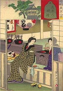
The development of Asakusa as an entertainment district during the Edo period came about in part because of the neighboring district, Kuramae. Kuramae was a district of storehouses for rice, which was then used as payment for servants of the feudal government. The keepers (fudasashi) of these storage houses initially stored the rice for a small fee, but over the years began exchanging the rice for money or selling it to local shopkeepers at a margin.[1] Through such trading, many fudasashi came to have a considerable amount of disposable income and as result theaters and geisha houses began to spring up in nearby Asakusa.
For most of the twentieth century, Asakusa remained a major entertainment district in Tokyo. The rokku or "Sixth District" was in particular famous as a theater district, featuring famous cinemas such as the Denkikan. The golden years of Asakusa are vividly portrayed in Yasunari Kawabata's novel The Scarlet Gang of Asakusa (1930; English translation, 2005). The area was heavily damaged by US bombing raids during World War II, particularly the March 1945 firebombing of Tokyo. The area was rebuilt after the war, but has now been surpassed by Shinjuku and other colorful areas in the city, in its role as a pleasure district.
Geography
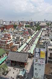
Asakusa is on the north-east fringe of central Tokyo, at the eastern end of the Tokyo Metro Ginza Line subway, approximately one mile east of the major Ueno railway/subway interchange. It is central to the area colloquially referred to as Shitamachi, which literally means "low city," referring to the low elevation of this old part of Tokyo, on the banks of the Sumida River. As the name suggests, the area has a more traditionally Japanese atmosphere than some other neighborhoods in Tokyo do.
Sightseeing and historic sites
With so many religious establishments, there are frequent matsuri (Shinto festivals) in Asakusa, as each temple or shrine hosts at least one matsuri a year, if not every season. The largest and most popular is the Sanja Matsuri in May, when roads are closed from dawn until late in the evening.
In a city where there are very few buildings older than 50 years because of the wartime bombing, Asakusa has a greater concentration of buildings from the 1950s and 1960s than most other areas in Tokyo do. There are traditional ryokan (guest-houses), homes, and small-scale apartment buildings throughout the district.
In keeping with a peculiarly Tokyo tradition, Asakusa hosts a major cluster of domestic kitchenware stores on Kappabashi-dori, which is visited by many Tokyoites for essential supplies.
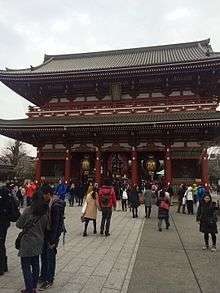
Next to the Sensō-ji temple grounds is a small amusement park called Hanayashiki, which claims to be the oldest amusement park in Japan. The neighborhood theaters specialize in showing classic Japanese films, as many of the tourists are elderly Japanese.
Cruises down the Sumida River depart from a wharf a five-minute walk from the temple.
Asakusa is Tokyo's oldest geisha district, and still has 45 actively working geisha.
Because of its colourful location, downtown credentials, and relaxed atmosphere by Tokyo standards, Asakusa is a popular accommodation choice for budget travelers.
Carnival
The neighborhood is famous for its annual Brazilian style carnival. There is a significant Brazilian presence in the local community and the Association of Samba Schools of Asakusa is based there.[2][3][4]
See also
In Art and Literature
- "Corn Dog," Season 1, Episode 2 of Midnight Diner, Tokyo Stories, a Netflix Original Series, (2016) is about an old comedian who works in Asakusa and his successful young protege.
References
- ↑ "Asakusa". http://www.furthereast.com/travel/asakusa/. External link in
|website=(help); - ↑ Tamborins.com.br (in Portuguese)
- ↑ http://extra.globo.com/blogs/rodadesamba/post.asp?t=tudo_sobre_congresso&cod_Post=15452&a=108[] Jornal Extra (in Portuguese)
- ↑ Brazilian Culture Ministry
External links
 Media related to Asakusa at Wikimedia Commons
 Tokyo/Asakusa travel guide from Wikivoyage
Coordinates: 35°42′53″N 139°47′48″E / 35.71472°N 139.79673°E