Aru, Jammu and Kashmir
| Aru | |
|---|---|
| village | |
|
Aru Valley | |
 Aru  Aru | |
| Coordinates: IN 34°5′27″N 75°15′48″E / 34.09083°N 75.26333°ECoordinates: IN 34°5′27″N 75°15′48″E / 34.09083°N 75.26333°E | |
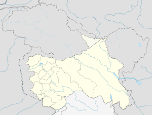
| Country | India |
| State | Jammu & Kashmir |
| District | Anantnag |
| Community development block in India | Khoviripora (Pahalgam) |
| Elevation[1] | 2,414 m (7,920 ft) |
| Time zone | IST (UTC+5:30) |
| Postal Index Number | 192126 |
| Census code | 00222700[2] |
Aru is a tourist spot in the Anantnag District of Jammu & Kashmir, India. It is located around 12 km from Pahalgam, 11 km upstream from the Lidder River. Noted for its scenic meadows, lakes and mountains, it is a base camp for trekking to the Kolhoi Glacier and Tarsar Lake. The village lies of the left bank of the Aru river, which is a tributary of the Lidder river.[3]
Tourism
The Aru valley is noted for its scenic meadows.[4][5] It is popular among the tourists for its peaceful environment and scenic beauty.
The village is a base camp for trekkers to the Kolahoi Glacier, the Tarsar-Marsar lakes and the Katrinag valley. It is also a base for the treks to Lidderwat, the Vishansar-Kishansar lakes and Kangan.[6][1] The Kolahoi is the largest glacier in the Kashmir Valley, and is located near Mt. Kolahoi (5425m), the highest peak in the Valley. A number of hotels, restaurants and huts are available for boarding and lodging.
There are about 20 alpine lakes, peaks and meadows around the Aru Valley. In the winters, when Aru receives heavy snowfall, skiing and heliskiing are practiced. Other popular tourist activities include fishing of trout in the Lidder river, trekking, hiking, horse riding, sightseeing and photography.
Overa-Aru Biosphere Reserve
The Overa-Aru Biosphere Reserve is located 76 km from the state capital Srinagar. It has the status of a Wildlife sanctuary, and is spread over an area of 511 km2.[7] The altitude ranges from 3000–5425 m above the sea level. It is famous for several rare and endangered species.[4]
-

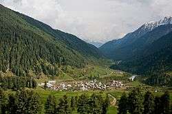
Entrance to Aru Village
-

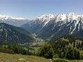
Landscape at Aru Valley
-
References
- 1 2 M.S. Kohli (1 April 2004). Mountains of India: Tourism, Adventure, Pilgrimage. Indus Publishing. p. 205–. ISBN 978-81-7387-135-1. Retrieved 16 April 2012.
- ↑ "Census codes for Kashmir Division" (PDF). J&K Energy Development Agency (JAKEDA). Retrieved 2012-04-16.
- ↑ Sharad Singh Negi (1991). Himalayan Rivers, Lakes, and Glaciers. Indus Publishing. p. 34. ISBN 978-81-85182-61-2. Retrieved 16 April 2012.
- 1 2 "Anantnag: Pahalgam". Anantnag District Administration. Retrieved 2012-04-16.
- ↑ Parvéz Dewân (15 January 2004). Parvéz Dewân's Jammû, Kashmîr, and Ladâkh: Kashmîr. Manas Publications. p. 149. ISBN 978-81-7049-179-8.
- ↑ "Pahalgam-Tarsar-Marsar Trek". www.kashmirtreks.in. Retrieved 2015-08-12.
- ↑ "ENVIS Newsletter: State Environment Related Issues, J&K" (PDF). Directorate of Environment & Remote Sensing. March 2003. Retrieved 2012-04-16.