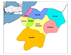
Artvin
| Artvin | |
|---|---|
| Municipality | |
|
Artvin Central Mosque and Park | |
 Artvin | |
| Coordinates: 41°11′00″N 41°49′05″E / 41.18333°N 41.81806°ECoordinates: 41°11′00″N 41°49′05″E / 41.18333°N 41.81806°E | |
| Country | Turkey |
| Province | Artvin |
| Government | |
| • Mayor | Mehmet Kocatepe (AKP) |
| Area[1] | |
| • District | 1,084.74 km2 (418.82 sq mi) |
| Elevation | 345 m (1,132 ft) |
| Population (2012)[2] | |
| • Urban | 25,771 |
| • District | 33,692 |
| • District density | 31/km2 (80/sq mi) |
| Post code | 0800 |
| Climate | Cfb |
| Website |
www |

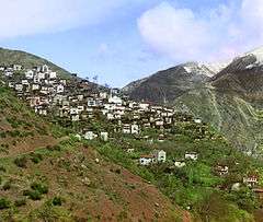
Artvin (Armenian: Արդվին, Ardvin; Georgian: ართვინი, Artvini) is a city in northeastern Turkey about 30 km inland from the Black Sea. It is located on a hill overlooking the Çoruh River near the Deriner Dam. It is home of Artvin Çoruh University.
History

The area has a rich history but has not been studied extensively by archaeologists in recent decades. Artifacts dating back to the Bronze Age and even earlier have been found. The Hurrians settled in the Artvin area in 2000 BC and were succeeded by the Urartu civilisation, based in Lake Van. Later, the area was part of the kingdom of Colchis but was always vulnerable to invasions, first the Scythians from across the Caucasus, then the Muslim armies led by Habib, son of Caliph Uthman who controlled the area from 853 AD to 1023 when it was conquered by the Byzantines from the Sac Emirate linked to the Abbasids.
The Seljuk Turks of Alp Arslan conquered the area in 1064 AD; but after his death, it was briefly recaptured by the king of Georgia with the help of the Byzantines. But in 1081 Turkish forces led by Saltukoğlu Beylik managed to take it back with the aid of Melikşah. With the collapse of the Seljuks, the Artvin area came under the control of the Ildeniz tribe of the Anatolian Turkish beyliks.[3][4][5][6][7][8][9][10] Various Turkish clans fought for control over the area and this continued until the Safavids ultimately took advantage of this fighting and conquered the area in 1502.
The Ottoman Empire under Mehmet II defeated the Empire of Trebizond to bring the eastern Black Sea coast and the mountainous hinterland under their control. Subsequent expeditions into the mountains by Selim I and Mehmed Han Yusufeli gave them control of a number of castles and thus the whole district. Kara Ahmet Pasha, the vizer of Suleiman I formed the first Livane Sanjak with the name Pert-Eğekte. On 13 July 1551, with İskender Pasha's Ardanuç castle, the Ottoman control of Artvin was secure. Ahmed III's vizer Hasan Pasha founded the city of Batum in the newly acquired lands of Ajaria and it became the hub of the area.
This lasted 250 years until the area was ceded to the Russians by the Ottoman Empire following the Russo-Turkish War (1828–1829), and recovered and again ceded at the conclusion of the Russo-Turkish War of 1877-78. Artvin was in a war zone and continuously changing control between Russia and Turkey with the Treaties of Brest-Litovsk, Moscow and Kars. All this fighting and uncertainty between Russia and Turkey in the late 19th century caused the people of Artvin to suffer terribly, with much of the population moving westwards away from the Russian-controlled zones.
In 1850, the Catholic Church established the eparchy of Artvin with jurisdiction over Catholic Armenians in the extreme northeast of Turkey and in the Caucasus. The first bishop of the see died in the following year. Another eparch was appointed in 1859. He resigned in 1878, when the whole province of Artvin came under the rule of Russia, which did not allow his successor to take possession of the see.[11][12][13][14] In the 20th century, Catholic Armenians throughout Russia were entrusted to an apostolic administrator resident in Tbilisi, but the Soviet authorities imprisoned him, and he died some time before 1937.[15] The Holy See continued to list the eparchy of Artvin as a vacant residential see until 1971,[16] but in 1972, accepting that it was no longer such, it began to list Artvin as a titular see.[17]
The Russians withdrew from Artvin following the Bolshevik Revolution of 1917; but when the First World War ended with the Ottomans on the losing side, British troops moved into the area in 1918, followed by the newly independent Georgians. There were moves to incorporate Artvin into Georgia but a referendum was called in 1920, and, knowing that the vast majority of the population were Turks, the Georgians withdrew their claim on Artvin in 1921 by the Treaty of Kars.[18]
Above the strategically placed town and road is the fortress, which was once within the medieval Georgian district of Nigali. The site consists of a single circuit wall surrounding the summit of the outcrop, several impressive rooms, an outwork protecting the south entrance, and a large donjon at the west. There are also embrasures and windows suitable for archers. In 1983 the fortress was surveyed and three years later an accurate scaled plan and description were published.[19]
Demographics
.jpg)
In the census of 1897, the town of Artvin was mainly populated by Armenians, whose forebears came from the Mush and Van region.[20] but the district in which it lay was largely Turkish. Outside of the town, the population in the district numbered 49,049 people, of whom 39,997 (82%) were Turks and 3,173 (6%) Armenian.[21]
| Year | Total | Ethnic groups |
|---|---|---|
| 1886[22] | 6,442 | Armenians 4,922 (76.4%), Turks 1,508 (23.88%) |
| 1897[23] | 7,091 | Armenians 4,646 (65.5%), Turks 1,491 (21%) |
| 1985[24] | 18,720 | |
| 1990[24] | 20,306 | |
| 2000[24] | 23,157 | |
| 2010[24] | 24,354 | |
Climate
Artvin, like the majority of the coastal Black Sea Region of Turkey, has an oceanic climate (Cfb) under Köppen classification and warm summer oceanic climate (Dob) under Trewartha classification.
| Climate data for Artvin (1950 - 2014) | |||||||||||||
|---|---|---|---|---|---|---|---|---|---|---|---|---|---|
| Month | Jan | Feb | Mar | Apr | May | Jun | Jul | Aug | Sep | Oct | Nov | Dec | Year |
| Record high °C (°F) | 18.9 (66) |
21.2 (70.2) |
28.4 (83.1) |
34.4 (93.9) |
36.4 (97.5) |
39.0 (102.2) |
42.0 (107.6) |
43.0 (109.4) |
39.5 (103.1) |
33.9 (93) |
27.9 (82.2) |
20.9 (69.6) |
43 (109.4) |
| Average high °C (°F) | 6.2 (43.2) |
8.2 (46.8) |
12.3 (54.1) |
17.9 (64.2) |
21.8 (71.2) |
24.1 (75.4) |
25.7 (78.3) |
26.2 (79.2) |
23.8 (74.8) |
19.6 (67.3) |
13.3 (55.9) |
7.8 (46) |
17.24 (63.03) |
| Daily mean °C (°F) | 2.8 (37) |
3.9 (39) |
7.0 (44.6) |
12.0 (53.6) |
15.9 (60.6) |
18.7 (65.7) |
20.8 (69.4) |
20.9 (69.6) |
18.1 (64.6) |
14.0 (57.2) |
9.0 (48.2) |
4.5 (40.1) |
12.3 (54.13) |
| Average low °C (°F) | −0.3 (31.5) |
0.3 (32.5) |
2.8 (37) |
7.2 (45) |
11.1 (52) |
14.2 (57.6) |
16.8 (62.2) |
17.0 (62.6) |
14.0 (57.2) |
10.2 (50.4) |
5.6 (42.1) |
1.6 (34.9) |
8.37 (47.08) |
| Record low °C (°F) | −16.1 (3) |
−11.9 (10.6) |
−9.8 (14.4) |
−7.1 (19.2) |
−0.6 (30.9) |
3.7 (38.7) |
9.5 (49.1) |
9.5 (49.1) |
4.2 (39.6) |
−1.6 (29.1) |
−8.2 (17.2) |
−10.8 (12.6) |
−16.1 (3) |
| Average precipitation mm (inches) | 87.4 (3.441) |
73.7 (2.902) |
61.6 (2.425) |
54.0 (2.126) |
52.2 (2.055) |
48.7 (1.917) |
31.9 (1.256) |
29.4 (1.157) |
35.9 (1.413) |
60.7 (2.39) |
76.4 (3.008) |
87.8 (3.457) |
699.7 (27.547) |
| Average precipitation days | 13.0 | 12.7 | 13.2 | 12.9 | 14.0 | 12.5 | 8.3 | 8.0 | 8.5 | 11.0 | 11.2 | 11.7 | 137 |
| Mean monthly sunshine hours | 71.3 | 90.4 | 130.2 | 156.0 | 195.3 | 213.0 | 201.5 | 204.6 | 189.0 | 139.5 | 93.0 | 65.1 | 1,748.9 |
| Percent possible sunshine | 24.2 | 30.3 | 35.2 | 39.0 | 43.3 | 46.8 | 43.7 | 47.7 | 50.6 | 40.6 | 31.5 | 22.9 | 37.98 |
| Source: Turkish State Meteorological Service[25] | |||||||||||||
Places of interest
- Artvin or Livana (Livane) castle, built in 937
There are a number of Ottoman Empire houses and public buildings including:
- Salih Bey mosque,[26] built in 1792
- Çarsi mosque, built in the 18th century[26]
- Balcioglu mosque, built in the 18th century[26]
- The fountain of Çelebi Efendi, built in 1783.
The surrounding countryside offers many places for climbing, trekking and rafting.
Events
Artvin is known for the Caucasus (Kafkas in Turkish) Culture and Arts Festival, a celebration that takes place at the Kafkasör plateau every year.[27] The most famous event is the Bull wrestling which draws many local and international visitors.[28]
Sister cities
Notes and references
- ↑ "Area of regions (including lakes), km²". Regional Statistics Database. Turkish Statistical Institute. 2002. Retrieved 2013-03-05.
- ↑ "Population of province/district centers and towns/villages by districts - 2012". Address Based Population Registration System (ABPRS) Database. Turkish Statistical Institute. Retrieved 2013-02-27.
- ↑ The Turks: Middle ages, Hasan Celāl Güzel, Cem Oğuz, Osman Karatay, 2002
- ↑ Les Origines de l'Empire ottoman, Mehmet Fuat Köprülü, Gary Leiser, 1992, page 82
- ↑ European and Islamic trade in the early Ottoman state: the merchants of Genoa and Turkey, Kate Fleet, 1999, page 49
- ↑ Turkey, Verity Campbell, 2007, page 35
- ↑ Turkey, James Bainbridge, 2009, page 33
- ↑ Eastern Turkey: The Bradt Travel Guide, Diana Darke, 2011, page 77
- ↑ The Turks: Early ages, Hasan Celāl Güzel, Cem Oğuz, Osman Karatay, 2002
- ↑ The sons of Bayezid: empire building and representation in the Ottoman civil war of 1402-1413, Dimitris J. Kastritsis, 2007, page 2
- ↑ Pius Bonifacius Gams, Series episcoporum Ecclesiae Catholicae, Leipzig 1931, p. 456
- ↑ Pius Bonifacius Gams, Series episcoporum Ecclesiae Catholicae, Supplement, Leipzig 1931, p. 93
- ↑ Joseph Lins, "Artvin" in The Catholic Encyclopedia (New York 1907)
- ↑ Christopher Lawrence Zugger, The Forgotten (Syracuse University Press 2001 ISBN 978-0-81560679-6), p. 60
- ↑ Chronology of Catholic Dioceses:Notes on the Armenian Catholic Eparchy of Artvin
- ↑ Annuario Pontificio 1971 (Tipografia Poliglotta Vaticana0, p. 41
- ↑ Annuario Pontificio 2013 (Libreria Editrice Vaticana 2013 ISBN 978-88-209-9070-1), p. 840
- ↑ Artvin Valiliği Resmi Web Sayfası <<! HOŞGELDİNİZ !>>
- ↑ Robert W. Edwards, “The Fortifications of Artvin: A Second Preliminary Report on the Marchlands of Northeast Turkey,” Dumbarton Oaks Papers 40, 1986, pp.165-70, pls. 2-10.
- ↑ Morgan Philips. War & Revolution in Asiatic Russia. London, G. Allen & Unwin ltd. 1918. Print. " But the town of Artvin is chiefly inhabited by Armenians, 9.000 in all, who have an interesting history. They are nearly all Roman Catholics; and according to one of the priests with whom I talked, their foerbears came from the Mush and Van region a hundred and fifty years ago, and settled here for the purpose of carrying on trade between the coast and the Armenian plateau along the line of the Chorokh river. "
- ↑ Первая всеобщая перепись населения Российской Империи 1897 г. Распределение населения по родному языку и уездам Российской Империи кроме губерний Европейской России (in Russian). Demoscope Weekly. Retrieved 11 August 2014.
- ↑ Свод статистических данных о населении Закавказского края, извлечённых из посемейных списков 1886 года, г. Тифлис, 1893. Available online here
- ↑ Первая всеобщая перепись населения Российской Империи 1897 г. Распределение населения по родному языку и уездам Российской Империи кроме губерний Европейской России (in Russian). Demoscope Weekly. Retrieved 8 April 2014.
- 1 2 3 4 "Artvin: Nüfus Bilgileri" (in Turkish). Belediyeler Konuşuyor. Retrieved 17 April 2014.
- ↑ "Meteoroloji" (in Turkish). Retrieved 8 January 2016.
- 1 2 3 Sinclair, T.A. (1989). Eastern Turkey: An Architectural & Archaeological Survey, Volume I. Pindar Press. p. 18. ISBN 9780907132325.
- ↑ Kafkasör Bull Wrestling Festival
- ↑ Bullwrestling in Artvin, Turkey
- The Catholic Encyclopedia
- Karadeniz Ansiklopedik Sözlük.İstanbul. 2005. ISBN 975-6121-00-9.
See also
External links
| Wikimedia Commons has media related to Artvin. |
- Governor's Office
- the Municipality
- Artvin Village (Turkish)
- local information (Turkish)
- Artvin Weather Forecast Information
- Artvin Otelleri