Arthur Wakerley

Arthur Wakerley (1862–1931) was a British architect, businessman and politician. Born in Melton Mowbray, he was articled to James Bird. He was a Fellow of the Royal Institute of British Architects and sometime President of the Leicester Society of Architects. He was President of the Leicester Liberal Association and in 1886 was elected as a councillor for Middle St Margaret's Ward and was Mayor of Leicester in 1897, the youngest mayor since the reforms of 1835. He used the role of mayor to support a wide range of charitable and religious works and attempted to position the role of mayor as a non-party political one.[1] His year of office was marred by two local disasters – the railway accident at Wellingborough and the Whitwick Colliery explosion that claimed 35 lives. He twice (unsuccessfully) contested the Melton Division for a seat in Parliament.[2] He stood as a Liberal candidate in 1895 and 1900.[3]
Outside work and politics Arthur Wakerley was an enthusiastic Wesleyan lay preacher and ardent temperance worker as well as being interested in archaeology and poetry.
He planned the development of the North Evington area.[4] Other examples of his architectural work in Leicester include the Turkey Cafe, Granby Street (1901), the Synagogue on Highfield Street,[5] the Coronation Buildings, High Street (1901–03; formerly known as the Singer Building)[6] and the Wycliffe Society Cottage Homes for the Blind.[7]
Grade II Listed buildings by Arthur Wakerley
Below is a list of the fourteen buildings in Leicester by Arthur Wakerley that have been listed. All are Grade II, and most relate to the period 1880s to 1900s. Many more of his building survive without being listed, including factories, terraced housing, semi-detached and detached houses, and 'Crown Hill', a substantial brick mansion he built for himself on Gwendolen Road. The listed post-war houses are four example pairs of the design of council house Wakerley produced in the 1920s, selected because they remain closest to the original design and have their original sash windows. As well as Leicester, the design was widely adopted in Glasgow, Belfast and Welwyn Garden City.[7]
| Name | Location | Type | Completed [note 1] | Date designated | Grid ref.[note 2] Geo-coordinates |
Entry number [note 3] | Image |
|---|---|---|---|---|---|---|---|
| No 8 Bishop Street | Town Hall Square, central Leicester | Solicitor's office | 1887 | 14 March 1975 | SK5886104310 52°38′00″N 1°07′54″W / 52.633359°N 1.1317236°W |
1200501 |  |
| Smith's shop | 122 London Road and 2–4 Highfield Street, Leicester | Shop | 1888 | 14 August 1997 | SK5965703688 52°37′40″N 1°07′12″W / 52.627681°N 1.1200757°W |
1245131 |  |
| Hunter Lodge | 138, Gwendolen Road, North Evington, now a local authority hostel, built as house for the Wycliffe Society for the Blind | Houses for blind people | 1897 | 10 September 2001 | SK6101704039 52°37′50″N 1°06′00″W / 52.630685°N 1.0999214°W |
1389422 |  |
| Leicester Hebrew Congregation | Synagogue on Highfield Street, Leicester | Place of worship | 1897-8 | 31 January 2002 | SK5979503795 52°37′43″N 1°07′05″W / 52.628628°N 1.1180179°W |
1389696 | 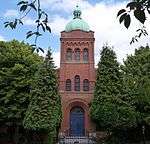 |
| Belgrave Hall Wesleyan Methodist Church | now Belgrave Community Centre, Leicester, on the corner of Belgrave Road and Rothley Street | Place of worship | 1898-9 | 13 September 2006 | SK5943405987 52°38′54″N 1°07′23″W / 52.64837°N 1.1229568°W |
1407227 |  |
| North Evington Police Station | Asfordby Street, Leicester. (Part of the North Evington Development Scheme) | Police Station | 1899 | 15 February 1994 | SK6061304791 52°38′15″N 1°06′21″W / 52.63749°N 1.1057518°W |
1263368 |  |
| The Singer Building | Now known as Coronation Building,76–88 High Street, Leicester | Commercial building | 1902–04 | 12 March 1996 | SK5847004521 52°38′07″N 1°08′15″W / 52.635298°N 1.1374628°W |
1270257 | 
|
| Wycliffe Hall | Gedding Road, North Evington. Built as Hall for Blind, now the Sam Cooper Day Centre | Social centre for blind people | 1906 | 10 September 2001 | SK6105504032 52°37′50″N 1°05′58″W / 52.630618°N 1.0993613°W |
1389423 |
|
| Wycliffe Society Houses | 65–75 Gedding Road, North Evington | Cottages for blind people | 1916–17 | 10 September 2001 | SK6107604054 52°37′51″N 1°05′57″W / 52.630813°N 1.099047°W |
1389424 |
|
| Royal Leicestershire, Rutland and Wycliffe Society for the Blind Workshops | Margaret Road, North Evington | Workshops for blind people | 1920–23 | 10 September 2001 | SK6101804092 52°37′52″N 1°06′00″W / 52.631162°N 1.0998968°W |
1389420 |
|
| 18 and 20, Linton Street | Highfields ('Wakerley Council House') | Council Houses | 1922 | 9 April 1996 | SK6042803535 52°37′34″N 1°06′31″W / 52.626221°N 1.1087146°W |
1268496 |  |
| 17 and 19 Dore Road | Highfields (Council Housing to Wakerley's design) | Council Houses | 1922 | 9 April 1996 | SK6050803627 52°37′37″N 1°06′27″W / 52.627039°N 1.1075161°W |
1268497 |  |
| 19 and 21 Great Arler Road | Knighton Fields (Council Housing to Wakerley's design) | Council Houses | 1922 | 9 April 1996 | SK5943101555 52°36′31″N 1°07′26″W / 52.608533°N 1.123797°W |
1268498 |  |
| 59 and 61 Dunster Street | Westcotes, (Council Housing to Wakerley's design) | Council Houses | 1922 | 9 April 1996 | SK5695004101 52°37′54″N 1°09′36″W / 52.631684°N 1.1599925°W |
1268499 | |
Notes to the table
- ↑ The date given is the date used by Historic England as significant for the initial building or that of an important part in the structure's description.
- ↑ Sometimes known as OSGB36, the grid reference is based on the British national grid reference system used by the Ordnance Survey.
- ↑ The "List Entry Number" is a unique number assigned to each listed building and scheduled monument by Historic England.
References
- ↑ James Moore, The Transformation of Urban Liberalism (Ashgate:2006),p.162.
- ↑ Welford Road Cemetery, http://www.webcitation.org/query?url=http://uk.geocities.com/welford_road_cemetery/wrc-w.htm&date=2009-10-25+04:32:58
- ↑ Debrett's House of Commons & Judicial Bench, 1901
- ↑ Victoria County History, Leicestershire. "Evington". British History Online. Retrieved 11 March 2016.
- ↑ http://www.britishlistedbuildings.co.uk/en-488423-leicester-hebrew-congregation-leicester
- ↑ "Archived copy". Archived from the original on 27 July 2014. Retrieved 2012-04-17.
- 1 2 JEAN FARQUAR, Arthur Wakerley 1862–1931 (London, Sedgebrook Press: 1984).