Arse (district)
| Arse | |
|---|---|
| District | |
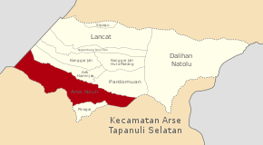
 Map Location of the District of Arse in South Tapanuli | |
| Coordinates: 1°41′42″N 99°17′36″E / 1.6949267°N 99.2934205°ECoordinates: 1°41′42″N 99°17′36″E / 1.6949267°N 99.2934205°E | |
| Country |
|
| Province | North Sumatra |
| Regency | South Tapanuli |
| District | Arse |
| District Capital | Arse Nauli |
| Area | |
| • Total | 208.09 km2 (80.34 sq mi) |
| Time zone | Indonesia Western Time |
| Website | www.tapselkab.go.id |
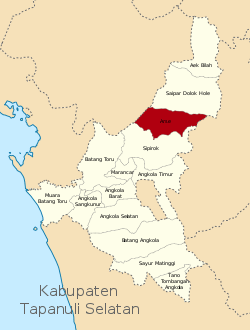
Arse is a district in the South Tapanuli Regency, North Sumatra province of Sumatra, Indonesia. It is located in the northern part of the island of Sumatra, around 220 kilometres (140 mi) south-east of the city of Medan. The district of Arse lies to the south of Saipar Dolok Hole.
The nearest airport to Arse is Ferdinand Lumban Tobing Airport, near the city of Sibolga, approximately 60 kilometres (37 mi) west of the district.
The district is divided into ten communities: Sipogu, Lancat, Natambang Roncitan, Nanggar Jati, Nanggar Jati Huta Padang, Aek Haminjon, Pardomuan, Dalihan Natolu, and the capital town Arse Nauli. As of the 2016 census, the population of Arse was estimated to be 8,012.[1] The population is mostly Muslim, with a small number of Protestant Christians.[2]
References
BPS (2016). "10 Tapanuli Selatan Regency iIn Figures 2016" (PDF). BPS - Statistics of Tapanuli Selatan Regency. Archived (PDF) from the original on 18 July 2016. Retrieved 18 July 2016.