Arrondissement of Narbonne
| Narbonne | |
|---|---|
| Arrondissement of France | |
 | |
| Country | France |
| Region | Occitanie |
| Department | Aude |
| Communes | 82 |
| Subprefecture | Narbonne |
| Area¹ | |
| • Total | 1,690 km2 (650 sq mi) |
| Population (2013) | |
| • Total | 158,495 |
| • Density | 94/km2 (240/sq mi) |
| ¹ French Land Register data, which exclude lakes, ponds, and glaciers larger than 1 km² as well as the estuaries of rivers. | |
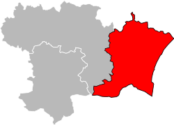
The arrondissement of Narbonne is an arrondissement of France in the Aude department in the Occitanie région. Its INSEE code is 113 and its capital city is Narbonne.
It is the easternmost and second largest of the arrondissements of the department, with an area of 1,690 km2 (652.5 sq mi).[1] It has 156,373 inhabitants and a density of 92.5 inhabitants/km².[2]
The main cities, with more than 5,000 inhabitants in 2012, in the arrondissement are Narbonne (51,869 inhabitants), Lézignan-Corbières (10,883 inhabitants), Coursan (6,056 inhabitants), Port-la-Nouvelle (5,653 inhabitants) and Sigean (5,476 inhabitants).[2]
History
When the Aude department was created on 17 February 1800, the arrondissement of Narbonne was part of that original department.[3]
Geography
The arrondissement of Narbonne is bordered to the north by the Hérault department, to the east by the Mediterranean Sea, to the south by the Pyrénées-Orientales department and to the west by the arrondissement of Carcassonne.
Composition
Cantons
The cantons of the arrondissement of Narbonne are:
- Coursan
- Fabrezan (partly)
- Lézignan-Corbières
- Narbonne-1
- Narbonne-2
- Narbonne-3
- Sallèles-d'Aude
- Sigean
Communes
The arrondissement of Narbonne has 82 communes; they are (with their INSEE codes):
| 1. Albas (11006) | 2. Argeliers (11012) | 3. Argens-Minervois (11013) | 4. Armissan (11014) |
| 5. Bages (11024) | 6. Bizanet (11040) | 7. Bize-Minervois (11041) | 8. Boutenac (11048) |
| 9. Camplong-d'Aude (11064) | 10. Canet (11067) | 11. Cascastel-des-Corbières (11071) | 12. Castelnau-d'Aude (11077) |
| 13. Caves (11086) | 14. Conilhac-Corbières (11098) | 15. Coursan (11106) | 16. Coustouge (11110) |
| 17. Cruscades (11111) | 18. Cucugnan (11113) | 19. Cuxac-d'Aude (11116) | 20. Duilhac-sous-Peyrepertuse (11123) |
| 21. Durban-Corbières (11124) | 22. Embres-et-Castelmaure (11125) | 23. Escales (11126) | 24. Fabrezan (11132) |
| 25. Ferrals-les-Corbières (11140) | 26. Feuilla (11143) | 27. Fitou (11144) | 28. Fleury (11145) |
| 29. Fontcouverte (11148) | 30. Fontjoncouse (11152) | 31. Fraissé-des-Corbières (11157) | 32. Ginestas (11164) |
| 33. Gruissan (11170) | 34. Homps (11172) | 35. Jonquières (11176) | 36. La Palme (11188) |
| 37. Leucate (11202) | 38. Luc-sur-Orbieu (11210) | 39. Lézignan-Corbières (11203) | 40. Mailhac (11212) |
| 41. Maisons (11213) | 42. Marcorignan (11217) | 43. Mirepeisset (11233) | 44. Montbrun-des-Corbières (11241) |
| 45. Montgaillard (11245) | 46. Montredon-des-Corbières (11255) | 47. Montséret (11256) | 48. Moussan (11258) |
| 49. Narbonne (11262) | 50. Névian (11264) | 51. Ornaisons (11267) | 52. Ouveillan (11269) |
| 53. Padern (11270) | 54. Paraza (11273) | 55. Paziols (11276) | 56. Peyriac-de-Mer (11285) |
| 57. Port-la-Nouvelle (11266) | 58. Portel-des-Corbières (11295) | 59. Pouzols-Minervois (11296) | 60. Quintillan (11305) |
| 61. Raissac-d'Aude (11307) | 62. Roquefort-des-Corbières (11322) | 63. Roubia (11324) | 64. Rouffiac-des-Corbières (11326) |
| 65. Saint-André-de-Roquelongue (11332) | 66. Saint-Jean-de-Barrou (11345) | 67. Saint-Laurent-de-la-Cabrerisse (11351) | 68. Saint-Marcel-sur-Aude (11353) |
| 69. Saint-Nazaire-d'Aude (11360) | 70. Sainte-Valière (11366) | 71. Salles-d'Aude (11370) | 72. Sallèles-d'Aude (11369) |
| 73. Sigean (11379) | 74. Thézan-des-Corbières (11390) | 75. Tourouzelle (11393) | 76. Treilles (11398) |
| 77. Tuchan (11401) | 78. Ventenac-en-Minervois (11405) | 79. Villedaigne (11421) | 80. Villeneuve-les-Corbières (11431) |
| 81. Villesèque-des-Corbières (11436) | 82. Vinassan (11441) |
References
- ↑ "Arrondissement de Narbonne (113) - Résumé statistique". Publications et statistiques pour la France ou les régions (in French). Institut national de la statistique et des études économiques - INSEE. Retrieved 15 August 2015.
- 1 2 "Populations lègales 2012 - 11-Aude". Populations légales 2012 des départements et des collectivités d'outre-mer (in French). Institut national de la statistique et des études économiques - INSEE. Retrieved 15 August 2015.
- ↑ "Historique de l'Aude". Le SPLAF (in French). Retrieved 15 August 2015.
Coordinates: 43°11′00″N 3°00′00″E / 43.1833°N 3.0000°E