Armstorf
| Armstorf | ||
|---|---|---|
|
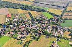
Aerial view in 2013 | ||
| ||
 Armstorf | ||
Location of Armstorf within Cuxhaven district 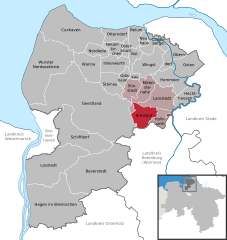
 | ||
| Coordinates: 53°35′57″N 09°04′32″E / 53.59917°N 9.07556°ECoordinates: 53°35′57″N 09°04′32″E / 53.59917°N 9.07556°E | ||
| Country | Germany | |
| State | Lower Saxony | |
| District | Cuxhaven | |
| Municipal assoc. | Börde Lamstedt | |
| Government | ||
| • Mayor | Heino Klintworth | |
| Area | ||
| • Total | 39.75 km2 (15.35 sq mi) | |
| Population (2015-12-31)[1] | ||
| • Total | 646 | |
| • Density | 16/km2 (42/sq mi) | |
| Time zone | CET/CEST (UTC+1/+2) | |
| Postal codes | 21769 | |
| Dialling codes | 04773 | |
| Vehicle registration | CUX | |
| Website | www.armstorf.de | |

Armstorf is a municipality in the district of Cuxhaven, in Lower Saxony, Germany.
History
Armstorf belonged to the Prince-Archbishopric of Bremen, established in 1180. In 1648 the Prince-Archbishopric was transformed into the Duchy of Bremen, which was first ruled in personal union by the Swedish Crown - interrupted by a Danish occupation (1712–1715) - and from 1715 on by the Hanoverian Crown. In 1807 the ephemeric Kingdom of Westphalia annexed the Duchy, before France annexed it in 1810. In 1813 the Duchy was restored to the Electorate of Hanover, which - after its upgrade to the Kingdom of Hanover in 1814 - incorporated the Duchy in a real union and the Ducal territory, including Armstorf, became part of the new Stade Region, established in 1823.
References
| Wikimedia Commons has media related to Armstorf. |
Towns and municipalities in Cuxhaven (district) | ||
|---|---|---|
This article is issued from Wikipedia - version of the 10/14/2016. The text is available under the Creative Commons Attribution/Share Alike but additional terms may apply for the media files.