Armour, Ontario
| Armour | |
|---|---|
| Township (single-tier) | |
| Township of Armour | |
|
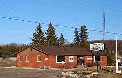
Municipal office | |
 Armour | |
| Coordinates: 45°37′44″N 79°20′37″W / 45.62889°N 79.34361°WCoordinates: 45°37′44″N 79°20′37″W / 45.62889°N 79.34361°W | |
| Country |
|
| Province |
|
| District | Parry Sound |
| Incorporated | 1998 |
| Government | |
| • Type | Township |
| • Reeve | Bob MacPhail |
| • MP | Tony Clement (CPC) |
| • MPP | Norm Miller (OPC) |
| Area[1] | |
| • Land | 164.44 km2 (63.49 sq mi) |
| Population (2011)[1] | |
| • Total | 1,372 |
| • Density | 8.3/km2 (21/sq mi) |
| Time zone | EST (UTC-5) |
| • Summer (DST) | EDT (UTC-4) |
| Postal code span | P0A |
| Area code(s) | 705 |
| Website | www.armourtownship.ca |
Armour (2011 population 1,372) is a township in the Canadian province of Ontario.
Located in the Almaguin Highlands region of Parry Sound District, the township surrounds but does not include the village of Burk's Falls. It was named in honour of Judge John Douglas Armour.[2]
Communities
The township includes the communities of Berriedale, Carss, Chetwynd, Katrine and Pickerel Lake.
Katrine overlooks Doe Lake, which is located on the west side of the village. Three Mile Lake and Deer Lake are located about 5 km east of the village. There is also a small public beach on Doe Lake, and a community centre located on Highway 11.[3]
Demographics
Population trend:[4]
- Population in 2011: 1372 (2006 to 2011 population change: 9.8%)
- Population in 2006: 1249
- Population in 2001: 1326
- Population in 1996: 1464
- Population in 1991: 1403
Private dwellings occupied by usual residents: 607 (total dwellings: 1074)
Mother tongue:[5]
- English as first language: 92.4%
- French as first language: 2.4%
- English and French as first language: 0%
- Other as first language: 5.2%
See also
References
- 1 2 Statistics Canada 2011 Census - Armour Census Profile
- ↑ "The Honourable Mr. Justice John Douglas Armour". Township of Armour. Retrieved 2010-08-17.
- ↑ "Katrine Ontario". Almaguin Communities. Almaguin Highlands Ontario Inc. Retrieved 2009-01-07.
- ↑ Statistics Canada: 1996, 2001, 2006, 2011 census
- ↑ "2006 Armour community profile".
External links
- Katrine Ontario Almaguin Highlands Regional Portal
 |
Magnetawan | Strong | Joly | |
| Ryerson | |
Kearney | ||
| ||||
| | ||||
| Perry |
| Towns | 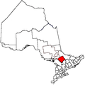 | |
|---|---|---|
| Townships | ||
| Villages | ||
| First Nations | ||
| Indian reserves | ||
| Local services boards | ||
| Unorganized areas | ||
| ||
This article is issued from Wikipedia - version of the 7/20/2016. The text is available under the Creative Commons Attribution/Share Alike but additional terms may apply for the media files.