Armenia, Colombia
| Armenia | |||
|---|---|---|---|
| "Miracle City" | |||
| |||
 Location of the city and municipality of Armenia in the Quindio Department | |||
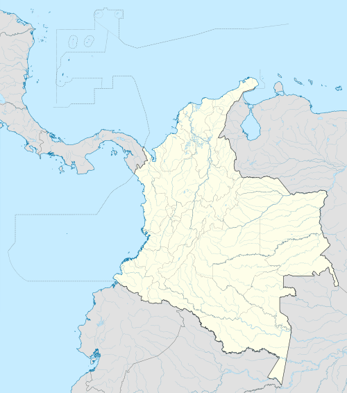 Armenia Location in Colombia | |||
| Coordinates: 4°32′N 75°41′W / 4.53°N 75.68°WCoordinates: 4°32′N 75°41′W / 4.53°N 75.68°W | |||
| Region | Andes Region | ||
| Departamento | Quindío | ||
| Founded | 1889 | ||
| Area | |||
| • Total | 140 km2 (50 sq mi) | ||
| Elevation | 1,551 m (5,089 ft) | ||
| Population (2012) | |||
| • Total | 292,008 | ||
| • Density | 2,100/km2 (5,400/sq mi) | ||
| Demonym(s) | Cuyabro(a) | ||
| Time zone | Eastern Time Zone (UTC-05) | ||
| Area code(s) | +57 (+6) | ||
| Website | Official website (Spanish) | ||

.svg.png)
Armenia is the capital of Quindio Department. It is one of the main centers of the national economy and of the Colombian coffee growing axis. Armenia is a medium-sized city located between Bogotá, Medellin and Cali, the three biggest cities in Colombia.
History

The city was founded on October 14, 1889 by Jesús María Ocampo, also known as "Tigrero" (translates to "tiger killer") due to his love of hunting jaguars, known locally as tigers. Ocampo came from Anaime, Tolima, looking for shelter in the mountains of Quindío since he was running away from General Gallo. He paid one hundred pesos in gold coins to Antonio Herrera for the land in which to build a fonda, or trade center, not only for himself but also for other colonists who came from Salento, Antioquia, Manizales and areas surrounding the Quindío River and La Vieja River. Ocampo then proceeded to sell land for settlement. To encourage settlement, Ocampo returned to Anaime to ask for the help of his friend Juan de la Cruz Cardona, and to marry thirteen-year-old Arsenia Cardona. Six months after its founding, in August 1890, Armenia had reached a population of 100 people, allowing it to gain legal recognition by the government. The city was initially called Villa Holguín, in honor of Carlos Holguín Mallarino, the then-current president of the country. It is believed the name was changed to Armenia after the country of the same name, in memory of the Armenian people murdered in the Turkish Ottoman Hamidian Massacres of 1894-97 in Western Armenia, and later the Armenian Genocide of 1915-23. It is also known by its nickname "Ciudad Milagro" (Miracle city).
Despite Armenia's quickly expanding economy at the time, the means of transport were still very limited. The main form of transporting people and merchandise was by mule, due to the mountainous terrain surrounding the city. It was not until the construction of the first asphalt road in 1927 to Zarzal in the Cauca river valley that transport was improved.
Nowadays, the city combines its contemporary development with the all traditional ways of its forefathers' heritage, like the historic Liberator Pathway, the path used by Colombia's 19th century Liberator Simon Bolívar to move his army between the west of the country and Santa Fe de Bogotá during his successful independence campaign from Spain, currently one of the top two tourist destinations in Colombia. Due to its namesake, many Armenian tourists also visit the city.
It is estimated that a large earthquake, approximately 6-7 in magnitude, will hit this area every 20 years due to high seismic activity. It can be explained by the Galapagos Triple Junction that occurs at the northwest corner of the South American Plate where the Nazca, Cocos, and Pacific plates converge.
Due to the link within the country Armenia, a memorial for the victims of the Armenian Genocide was built in the city. This is the only Armenian Genocide memorial in Colombia.
The 1999 earthquake
On Monday, January 25, 1999, an ML = 6.2 earthquake occurred in Quindío. The epicenter was located 17 km south of Armenia. The earthquake was one of the most devastating events to have occurred in Colombia in recent history. The earthquake was also felt in Risaralda, Valle Del Cauca, Tolima, Antioquia and Cundinamarca but Armenia was the hardest-hit city. In just 15 years, the city was rebuilt, becoming one of the most visited tourist destinations in Colombia. [1]
Geography

The city of Armenia is located 290 kilometers southwest of Bogota at a height of 1,483 m., Geographical coordinates, the following: 4.3270° north latitude 75.4120° west longitude. It has an area of 121 km2 (47 sq mi). It limits the north with the municipalities of Circasia and Salento, west to the town of Montenegro, east to the town of Calarcá and south with the municipality of La Tebaida. Armenia is situated close to the center Cordillera about 35 km (22 mi) from the top of the line. The climate of the city of Armenia is varied, the average temperature ranges between 18–21 °C (64–70 °F).
Economy
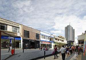
Armenia is often referred to as "Ciudad Milagro" (Miracle City) due to its fast urban growth and development. For many residents, the name "Miracle City" resulted from the rapid rebuilding of the city following the 1999 earthquake. The city center has dozens of new buildings with better architectural standards to prevent the type of damage and loss of life that occurred during the 1999 earthquake. The city center includes a nine block pedestrian walkway, lined by shops and restaurants, through the center of the city and connecting two of the city's plazas. The local economy main trade is still based on the production of coffee, plantains, and bananas. To the south of the city as it gets closer to sea level, the temperature favors not only Quindio's agricultural economy, but a renewed tourist industry in the shape of villas for rent, theme parks, eco-hotels and family day leisure centers, not excluding all-time favorites like local cuisine restaurants, exhibition centers and country clubs specializing in fishing, tennis, golf, cart racing and other sports. Many traditional plantations still exist in the surrounding area and many offer bed and breakfast accommodation and "ecotourism" packages. The city has a modern international airport El Edén International Airport with daily links to Bogotá, Cartagena de Indias, Medellín and Fort Lauderdale which make the city a convenient choice for conferences, meetings, business and social events.
Transport

Armenia is part of the program "friendly cities" which seeks to improve the quality and service in urban transport in major urban centers of the country.
The city of Armenia implements its program called strategic public transport system, which is a program that advances the town hall by Friendly Company, an industrial and commercial entity been created to manage project resources.
The Strategic Public Transport System comes from the national strategy Gracious Cities National Development Plan which aims to improve the provision of public transport in intermediate cities of less than 400,000 inhabitants. It results from a national urban transport program established in 3167 CONPES of May 23, 2002 and responds to the need to establish a system that structures and allow better management of the city.
Thanks to the union of the three main utilities urban city (Armenia Buses, Urban Transport and Cooburquin City Miracle, new company was formed transport operator in the city, called RED (Integrated Transport Operator of Armenia), the showing its citizens a new image, whose main characteristic, coffee, icon of the city and the department.
Part of this information is captured, is taken from Armenia Friendly program, the website of the Mayor of the City
Tourism and folklore


The renewed tourist industry has activated the popularity of the city and its surrounding areas. The region's northern area is the gateway to Los Nevados national park, where the highest peaks in central Colombia rise to perpetual snows at more than 4,500 metres. At the Quindio side of the foothills of this national park, lies the magnificent Cocora valley, where the National Tree of Colombia, the wax palm grows, and whose municipality of Salento is a top tourist destination famous for its culinary delicacy (fried river trout), for its guadua crafts and furniture (the strong native bamboo cane), its art galleries and its fame for being the bohemian centre of regional artists. Tourists and hikers walk from here to reach the spectacular views of the park.
The county's folklore is rich and is represented throughout events and traditions visible during most of its towns festivities to name a few:
The Yipao (Parade of Jeeps): After World War II Armenia was given imported general purpose Jeeps vehicles so that they may be used for the difficult paths. However, these old vehicles have been also adopted into a traditional parade carrying oversized loads of coffee, local agriculture products and people.
The Chapoleras beauty pageant, with costumes depicting the traditional coffee harvesting dress in the fashion of late 19th century, and the various popular dances is widely known in the entire country.
Each fall, La Asociacion Quindiana de Orquideologia hosts a large orchid show, open to the public. This includes local judging by Colombian judges and often international judging by the American Orchid Society. In 2011, the show will be held on Oct. 6-9, at Coorporacion Autonoma Regional del Quindio (CRQ).
The city is certainly a cultural centre, right in the heart of the coffee region. Due to its pleasant weather, and beautiful vistas, middle-class people from neighbouring areas are quietly buying up luxurious properties left behind after the cocaine era.
Among the many attractions in the region, Colombian National Coffee Park, a theme park dedicated to the meticulous process of growing coffee and bringing it to the table for enjoyment is a major landmark. The park has all sorts of attractions for all ages.
PANACA, also a theme park, is an agricultural centre. At Panaca, tourists get in touch with nature. Animals, and crops commonly seen in the region interact in a personal manner with tourists. It is a great chance for people to learn and enjoy agriculture and get in touch with all sorts of animals seen in Colombia's agricultural areas.
Art and handcrafts
This region was widely known in the country in the early 20th century for the production of storage receptacles made of the empty dried shell of the fruit of a local species of inedible bottle gourd, the "Cuyabra" or "totumo", which gives the demonym of "cuyabros" to the people born in this city. Nowadays, they are no longer mass-produced for practical purposes as cheaper materials such as plastics displaced them from the market, but these traditional receptacles are still produced and hand-painted.
The Carriel is a traditional handbag leather handcraft symbolic of the paisa culture and the early antioquian colonisation. It is often used in the typical dances and parades, and its miniature version is sold to tourists as souvenir. The cabuya handicrafts are often seen.
The bamboo guadua is widely used in creation of art crafts, furniture and buildings.
Education and sports
The main sports centre in the city is the Centenario Stadium, where local sporting events can be seen, including national and international football tournaments and the local professional football club Deportes Quindío. Other sport events are bullfighting, golf, swimming and cycling. The highly varied geography surrounding Armenia has helped create some of the greatest climbing cyclists in the world, many of whom compete internationally in events such as the Tour de France.
The Quimbaya museum designed by Rogelio Salmona, offers a permanent display of precolumbian handcrafts, ceramic and gold artpieces.
Media
- Newspaper: La Crónica del Quindío
- Television: Telecafé
Transportation
Sister cities
Colombia:
International:
References
External links
| Wikivoyage has a travel guide for Armenia (Colombia). |
| Wikimedia Commons has media related to Armenia, Colombia. |
| Population over 50,000 |  | |
|---|---|---|
| Population over 20,000 | ||
| Population under 20,000 | ||