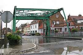
Armbouts-Cappel
| Armbouts-Cappel Armboutskappel | ||
|---|---|---|
 | ||
| ||
 Armbouts-Cappel | ||
|
Location within Hauts-de-France region  Armbouts-Cappel | ||
| Coordinates: 50°58′42″N 2°21′15″E / 50.9783°N 2.3542°ECoordinates: 50°58′42″N 2°21′15″E / 50.9783°N 2.3542°E | ||
| Country | France | |
| Region | Hauts-de-France | |
| Department | Nord | |
| Arrondissement | Dunkerque | |
| Canton | Bergues | |
| Intercommunality | Dunkerque grand littoral | |
| Government | ||
| • Mayor (2008–2014) | Jean-Luc Darcourt | |
| Area1 | 10.15 km2 (3.92 sq mi) | |
| Population (2009)2 | 2,468 | |
| • Density | 240/km2 (630/sq mi) | |
| Time zone | CET (UTC+1) | |
| • Summer (DST) | CEST (UTC+2) | |
| INSEE/Postal code | 59016 / 59380 | |
| Elevation |
0–6 m (0–20 ft) (avg. 2 m or 6.6 ft) | |
|
1 French Land Register data, which excludes lakes, ponds, glaciers > 1 km² (0.386 sq mi or 247 acres) and river estuaries. 2 Population without double counting: residents of multiple communes (e.g., students and military personnel) only counted once. | ||
Armbouts-Cappel (from Dutch: Armboutskappel) is a commune in the Nord department in northern France.
It is a few kilometers south of Dunkirk.
Population
| Historical population | ||
|---|---|---|
| Year | Pop. | ±% |
| 1793 | 404 | — |
| 1800 | 453 | +12.1% |
| 1806 | 469 | +3.5% |
| 1821 | 540 | +15.1% |
| 1831 | 613 | +13.5% |
| 1836 | 696 | +13.5% |
| 1841 | 798 | +14.7% |
| 1846 | 833 | +4.4% |
| 1851 | 850 | +2.0% |
| 1856 | 864 | +1.6% |
| 1861 | 922 | +6.7% |
| 1866 | 1,005 | +9.0% |
| 1872 | 1,052 | +4.7% |
| 1876 | 1,100 | +4.6% |
| 1881 | 1,159 | +5.4% |
| 1886 | 1,162 | +0.3% |
| 1891 | 1,146 | −1.4% |
| 1896 | 1,227 | +7.1% |
| 1901 | 1,164 | −5.1% |
| 1906 | 1,206 | +3.6% |
| 1911 | 1,206 | +0.0% |
| 1921 | 1,159 | −3.9% |
| 1926 | 1,153 | −0.5% |
| 1931 | 1,137 | −1.4% |
| 1936 | 1,092 | −4.0% |
| 1946 | 828 | −24.2% |
| 1954 | 1,033 | +24.8% |
| 1962 | 1,049 | +1.5% |
| 1968 | 1,048 | −0.1% |
| 1975 | 1,178 | +12.4% |
| 1982 | 2,562 | +117.5% |
| 1990 | 2,656 | +3.7% |
| 1999 | 2,674 | +0.7% |
| 2006 | 2,458 | −8.1% |
| 2009 | 2,468 | +0.4% |
Heraldry
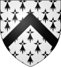 |
The arms of Armbouts-Cappel are blazoned : Ermine, a chevron sable. |
See also
References
| Wikimedia Commons has media related to Armbouts-Cappel. |
This article is issued from Wikipedia - version of the 8/17/2016. The text is available under the Creative Commons Attribution/Share Alike but additional terms may apply for the media files.