Argyre Planitia
|
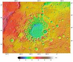
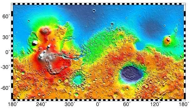
Colorized topographic map of Argyre basin and its surroundings, from the MOLA instrument of Mars Global Surveyor. | |
| Planet | Mars |
|---|---|
| Coordinates | 49°42′S 316°00′E / 49.7°S 316.0°ECoordinates: 49°42′S 316°00′E / 49.7°S 316.0°E |
| Diameter | 1,800 km (1,100 mi) |
| Depth | 5.2 km (17,000 ft) |
| Eponym | Legendary island Argyre |
Argyre Planitia[1] is a plain located within the impact basin Argyre[lower-alpha 1] in the southern highlands of Mars. Its name comes from a map produced by Giovanni Schiaparelli in 1877; it refers to Argyre, a mythical island of silver in Greek mythology.
Argyre is centered at 49°42′S 316°00′E / 49.7°S 316.0°E and lies between 35° and 61° S and 27° and 62° W in the Argyre quadrangle. The basin is approximately 1,800 km (1,100 mi) wide and drops 5.2 km (17,000 ft) below the surrounding plains; it is the second deepest impact basin on Mars after Hellas. The crater Galle, located on the east rim of Argyre at 51°S 31°W / 51°S 31°W, strongly resembles a smiley face.
The basin was possibly formed by a giant impact during the Late Heavy Bombardment of the early Solar System, approximately 3.9 billion years ago, and may be one of the best preserved ancient impact basins from that period. Argyre is surrounded by rugged massifs which form concentric and radial patterns around the basin. Several mountain ranges are present, including Charitum and Nereidum Montes.[3]
Past water flows
Four large Noachian epoch channels lie radial to the basin. Three of these channels (Surius Valles, Dzígai Valles, and Palacopas Valles) flowed into Argyre from the south and east through the rim mountains. The fourth, Uzboi Vallis, appears to have flowed out from the basin's north rim to the Chryse region and may have drained a lake of melting ice within the basin. A smaller outflow channel named Nia Valles is relatively fresh-looking, and probably formed during the early Amazonian after the major fluvial and lacustrine episodes had finished.[4]
The original basin floor is buried with friable, partially deflated layered material that may be lake sediment. No inner rings are visible; however, isolated massifs within the basin may be remnants of an inner ring.[3]
Past habitability
The impact that formed the Argyre basin probably struck an ice cap or a thick permafrost layer. Energy from the impact melted the ice and formed a giant lake that eventually sent water to the North. The lakes's volume was equal to that of Earth's Mediterranean Sea. The deepest part of the lake may have taken more than a hundred thousand years to freeze, but with the help of heat from the impact, geothermal heating, and dissolved solutes it may have had liquid water for many millions of years. The basin would have supported a regional environment favorable for the origin and the persistence of life.[5] This region shows a great deal of evidence of glacial activity with flow features, crevasse-like fractues, drumlines, eskers, tarns, aretes, cirques, horns, U-shaped valleys, and terraces. Because of the shapes of Argyre sinuous ridges, the authors agree with previous publications in that they are eskers.[6]
Based on morphometrical and geomorphological analysis of the Argyre eskers and their immediate surroundings, it was suggested that they formed beneath an approximately 2 km thick, stagnant (i.e., stationary) ice sheet around 3.6 billion years ago. This stagnant body of ice might have resembled a Piedmont-style glacier comparable to today's Malaspina Glacier in Alaska.[7]
Gallery
-
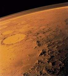
The southern rim of Argyre basin, formed by the Charitum Montes. Adjacent are sinuous ridges, theorized to be glacial eskers. The crater Galle is seen in the background.
-

MOLA maps showing the geographic context of Argyre.
-

MOLA map showing boundaries for Argyre Planitia and other regions
-

Gullies south of Argyre appear to be unequivocal evidence of water erosion.
-
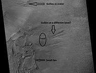
Scene in Argyre quadrangle with gullies, alluvival fans, and hollows, as seen by HiRISE under HiWish program. Enlargements of parts of this image are below.
-
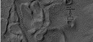
Several levels of alluvial fans, as seen by HiRISE under HiWish program. Locations of these fans are indicated in the previous image.
-
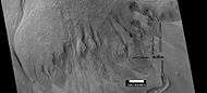
Small, well-formed alluvial fan, as seen by HiRISE under HiWish program. Location of this fan is shown in an image displayed above.
-
Enlargement of above image showing hollows with box showing the size of a football field, as seen by HiRISE under HiWish program.
-
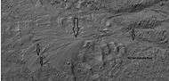
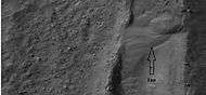
Gullies, as seen by HiRISE under HiWish program. Location is Nereidum Montes.
-

Surface in Argyre quadrangle as seen by HiRISE, under the HiWish program. This is the image of the surface from a single HiRISE image. The scale bar at the top is 500 meters long.
-

CTX image showing context for the next image. A group of channels are visible in this image.
-

Close-up of surface in Argyre quadrangle, as seen by HiRISE, under the HiWish program.
Interactive Mars map
See also
Notes
References
- ↑ "Argyre Planitia". Gazetteer of Planetary Nomenclature. USGS Astrogeology Science Center. Retrieved 2013-11-29.
- ↑ "Argyre". Gazetteer of Planetary Nomenclature. USGS Astrogeology Science Center. Retrieved 2013-11-29.
- 1 2 'Topography and morphology of the Argyre Basin, Mars.' Hiesinger & Head.
- ↑ Argyre Planitia and the Mars Global Hydrologic Cycle'. Parker et al.
- ↑ Fairén Alberto G.; Dohm James M.; Rodríguez J. Alexis P.; Uceda Esther R.; Kargel Jeffrey; Soare Richard; Cleaves H. James; Oehler Dorothy; Schulze-Makuch Dirk; Essefi Elhoucine; Banks Maria E.; Komatsu Goro; Fink Wolfgang; Robbins Stuart; Yan Jianguo; Miyamoto Hideaki; Maruyama Shigenori & Baker Victor R. (February 2016). "The Argyre Region as a Prime Target for in situ Astrobiological Exploration of Mars" (PDF). Astrobiology. 16 (2): 143–158. doi:10.1089/ast.2015.1396. Retrieved 2016-03-12.
- ↑ Dohm, J.; Hare, T.; Robbins, S.; Williams, J.-P.; Soare, R.; El-Maarry, M.; Conway, S.; Buczkowski, D.; Kargel, J.; Banks, M.; Fairén, A.; Schulze-Makuch, D.; Komatsu, G.; Miyamoto, H.; Anderson, R.; Davila, A.; Mahaney, W.; Fink, W.; Cleaves, H.; Yan, J.; Hynek, B.; Maruyama, S. (2015). "Geological and hydrological histories of the Argyre province, Mars". Icarus. 253: 66–98. Bibcode:2015Icar..253...66D. doi:10.1016/j.icarus.2015.02.017.
- ↑ Bernhardt, H.; Hiesinger, H.; Reiss, D.; Ivanov, M. A.; Erkeling, G. (2013). "Putative eskers and new insights into glacio-fluvial depositional settings in southern Argyre Planitia, Mars". Planetary and Space Science Conference. 85: 261–278. Bibcode:2013P&SS...85..261B. doi:10.1016/j.pss.2013.06.022.
External links
- Argyre Planitia map at Google Mars
- Lakes on Mars - Nathalie Cabrol (SETI Talks)