Argyle Building, Glasgow
| Argyle Building | |
|---|---|
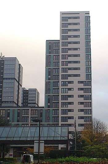 The Argyle Building, with the Anderston Centre towers to the immediate left. | |
| General information | |
| Status | Complete |
| Type | Residential |
| Architectural style | Modernist |
| Address | 490 Argyle Street |
| Town or city | Anderston, Glasgow |
| Country | Scotland |
| Construction started | 2005 |
| Completed | 2008 |
| Height | 62 m (203 ft) |
| Technical details | |
| Floor count | 21 |
| Lifts/elevators | 2 |
| Design and construction | |
| Architecture firm | Aedas Architects |
| Main contractor | Taylor Wimpey Ltd |
The Argyle Building is a mid-rise residential skyscraper in the Anderston district within the centre of Glasgow, Scotland. Started in 2005 and completed in 2008, it is among the highest buildings currently standing within the city's central area and occupies a prominent spot next to the Kingston Bridge and the M8 motorway. It can be seen prominently in the background of BBC Scotland television news bulletins.[1][2]
Background
The Argyle Building was conceived as part of the regeneration of the Anderston Centre complex which was built around the turn of the 1970s, which had steadily fallen into partial dereliction. The tower was part of wider gentrification efforts to regenerate the Anderston area as part of the Glasgow International Financial Services District initiative, thereby encouraging young professionals to live as well as work in the area. The tower forms part of the Cuprum office development, which occupies the lower four levels and adjoins directly onto its eastern side. The building is of largely Modernist in its design, and has features which are intended to mimic the style of the Anderston Centre's tower blocks which stand directly adjacent.[3][4]
References
- ↑ "Taylor Wimpey - The Argyle Building - GSPC - Glasgow ...". gspc.co.uk. Retrieved 11 March 2014.
- ↑ "Final duo left at The Argyle Building in Glasgow". taylorwimpey.co.uk. Retrieved 11 March 2014.
- ↑ "Argyle Street | Glasgow History". glasgowhistory.com. Retrieved 11 March 2014.
- ↑ "Argyle Building, Glasgow". linernotes.com. Retrieved 11 March 2014.
Coordinates: 55°51′35″N 4°16′04″W / 55.85960°N 4.26767°W