Arghakhanchi District
| Arghākhānchī Jillā अर्घाखाँची जिल्ला | |
|---|---|
| District | |
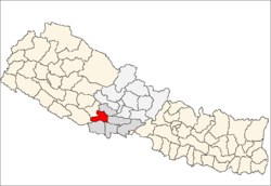 Location of Arghakhanchi in Lumbini | |
| Country | Nepal |
| Region | Western (Pashchimanchal) |
| Zone | Lumbini |
| Headquarters | Sandhikharka |
| Area | |
| • Total | 1,193 km2 (461 sq mi) |
| Population (2011) | |
| • Total | 197,632[1] |
| Time zone | NPT (UTC+5:45) |
| Main language(s) | Nepali |
| Website |
arghakhanchi |
Arghakhanchi (Nepali: अर्घाखाँची जिल्ला![]() Listen )is one of the districts of Province No. 5 in Nepal. The district headquarter is Sandhikharka. The district covers an area of 1,193 km² and has a population (2011) of 197,632.[1] Its neighboring districts are, Palpa in the east, Gulmi in the North, Kapilbastu in the south and Pyuthan in the west. The famous places are Supa Deurali (Supa Deurali Temple), Argha (MahaKali Temple) and Chhatraganj Temple, Narsing Thana at Hanshapur Bamruk,Sattle Gupha, etc.
Listen )is one of the districts of Province No. 5 in Nepal. The district headquarter is Sandhikharka. The district covers an area of 1,193 km² and has a population (2011) of 197,632.[1] Its neighboring districts are, Palpa in the east, Gulmi in the North, Kapilbastu in the south and Pyuthan in the west. The famous places are Supa Deurali (Supa Deurali Temple), Argha (MahaKali Temple) and Chhatraganj Temple, Narsing Thana at Hanshapur Bamruk,Sattle Gupha, etc.
History
The district consists of two pre-unification principalities Argha and Khanchi. Argha (Nepali:अर्घा) was the name given to ritual offerings made at the former principality's main Bhagwati Temple. Khanchi may come from the word Khajanchi (Nepali:खजाञ्चि) or tax collector since the center of the latter principality was known for its tax office. Both were two of the Chaubisi rajya (24 principalities) centered in the Gandaki Basin. In 1786 A.D. (1843 BS) during the unification of Nepal the two were annexed by Gorkha. Later the merger was renamed “Arghakhanchi” and added to Gulmi District. Arghakhanchi became a separate district in 1961 A.D. (2018 BS).[2]
Demographics
In 2001, the population was 208,391.[3] In 1991, the population was 180,884.[3] According to the 2011 census the total population was 197,632. Of these 86,266 were male and 111,366 are female. Total no of household 46,835 and average household size 4.22 on the basis of usual place of residence. Sex ratio ( No of male per 100 female population) is 77.5 and population density 166.The major religion of this district are Hindu and also followed by Muslims too.[1]
Geography and Climate
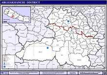
Arghakhanchi lies between 27'45"N and 28'6"N latitude, and 80'45"E to 83'23"E longitude. It covers 1,193 km². The altitude of the district varies from 305 to 2515 meter above the sea level. 68% of the district is in the mountainous Mahabharat Range and the rest is in the Siwalik Hills. Elevations range from 305–2575 m above sea level and about 40% of the total area is forested.[2] The major rivers of the district are Bangi khola, Bangsari Khola, Mathurabesi Khola, Banganga Khola, Durga khola, Sita khola, Khakabesi Khola, Rangsing Khola, Ratne Khola, Jhimruk Khola, Khankbesi Khola etc.. The major lakes of the district are Thada lake and Sengleng lake.
| Climate Zone[4] | Elevation Range | % of Area |
|---|---|---|
| Lower Tropical | below 300 meters (1,000 ft) | 0.2% |
| Upper Tropical | 300 to 1,000 meters 1,000 to 3,300 ft. |
50.5% |
| Subtropical | 1,000 to 2,000 meters 3,300 to 6,600 ft. |
49.1% |
| Temperate | 2,000 to 3,000 meters 6,400 to 9,800 ft. |
0.2% |
Towns and Villages
The major town in the district is Sandhikharka which is the headquarter of Arghakhanchi district in the Lumbini Zone of Nepal. It is located almost 300 km southwest of Nepal's capital of Kathmandu. Due to a high literacy rate, Sandhikharka once attracted people from outside Arghakhanchi district to Sandhikharka for its good schools. There are a large number of small villages in the district.Mareng,Bhagawati, Asurkot, Lamchi, Balkot, Bangi, Dharmpani, Dhikura, Dibharna, Khanchikot, Kimadada, Kura, Phudbang, Bangla, Adguri , Khana, Khanadaha, Pali, Dhatiwang, etc. One of the famous school of Arghakhachi is in Hatari Neta which provides one of the finest education in the level of government sector. They are said to have good facilities in terms of roads, electric power, education, etc. Villages in the west and south part of the district have relatively little development as compared to the villages of the north and east side. Sano Gaun is the most popular place for visit. Lamchi is another popular village in Arghakhanchi. Deurali temple is one the famous temple for all those local people as well as people who are near the Arghakachi district In the context of visiting and religious place there of lots of temples and monuments on this districts which includes Suppa Deurali , Argha Mandir and others temples too. The income of people are solely depends on the remittance and the agriculture.And some people are also engaged on the shops, too. There are many rivers which flows on Argakhachi district among them Sisnae Khola, Bada khola, Saurae khola are majors streams of the district.
References
- 1 2 3 "National Population and Housing Census 2011(National Report)" (PDF). Central Bureau of Statistics. Government of Nepal. November 3, 2012. Retrieved November 3, 2012.
- 1 2 "Districts". 28 June 2012. Archived from the original on June 18, 2010. Retrieved 18 August 2012.
- 1 2 "Nepal Districts". statoids.com. Retrieved 18 August 2012.
- ↑ The Map of Potential Vegetation of Nepal - a forestry/agroecological/biodiversity classification system (PDF), . Forest & Landscape Development and Environment Series 2-2005 and CFC-TIS Document Series No.110., 2005, ISBN 87-7903-210-9, retrieved Nov 22, 2013
External links
| Wikimedia Commons has media related to Arghakhanchi District. |
Coordinates: 28°0′3″N 83°14′48″E / 28.00083°N 83.24667°E