Arcadia, Missouri
| Arcadia, Missouri | |
|---|---|
| City | |
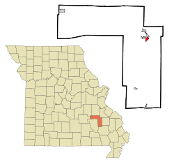 Location of Arcadia within Iron County, Missouri | |
| Coordinates: 37°35′17″N 90°37′44″W / 37.58806°N 90.62889°WCoordinates: 37°35′17″N 90°37′44″W / 37.58806°N 90.62889°W[1] | |
| Country | United States |
| State | Missouri |
| County | Iron |
| Area[2] | |
| • Total | 0.84 sq mi (2.18 km2) |
| • Land | 0.83 sq mi (2.15 km2) |
| • Water | 0.01 sq mi (0.03 km2) |
| Elevation[1] | 909 ft (277 m) |
| Population (2010)[3] | |
| • Total | 608 |
| • Estimate (2012[4]) | 591 |
| • Density | 720/sq mi (280/km2) |
| Time zone | CST (UTC-6) |
| • Summer (DST) | CDT (UTC-5) |
| ZIP code | 63621 [5] |
| Area code | 573 |
| FIPS code | 29-01648 [1] |
| GNIS feature ID | 0748606 [1] |
Arcadia is a city in Iron County, Missouri, United States.[1] The population was 608 at the 2010 census.
History
Arcadia was laid out and platted in 1849.[6] It was named after the Greek region of Arcadia.[7][8] A post office called Arcadia has been in operation since 1871.[9]
Geography
According to the United States Census Bureau, the city has a total area of 0.84 square miles (2.18 km2), of which, 0.83 square miles (2.15 km2) is land and 0.01 square miles (0.03 km2) is water.[2]
Demographics
| Historical population | |||
|---|---|---|---|
| Census | Pop. | %± | |
| 1860 | 135 | — | |
| 1870 | 250 | 85.2% | |
| 1880 | 259 | 3.6% | |
| 1890 | 408 | 57.5% | |
| 1900 | 205 | −49.8% | |
| 1910 | 289 | 41.0% | |
| 1930 | 273 | — | |
| 1940 | 346 | 26.7% | |
| 1950 | 414 | 19.7% | |
| 1960 | 489 | 18.1% | |
| 1970 | 627 | 28.2% | |
| 1980 | 683 | 8.9% | |
| 1990 | 609 | −10.8% | |
| 2000 | 567 | −6.9% | |
| 2010 | 608 | 7.2% | |
| Est. 2015 | 575 | [10] | −5.4% |
2010 census
As of the census[3] of 2010, there were 608 people, 293 households, and 164 families residing in the city. The population density was 732.5 inhabitants per square mile (282.8/km2). There were 320 housing units at an average density of 385.5 per square mile (148.8/km2). The racial makeup of the city was 99.0% White, 0.7% African American, 0.2% Native American, and 0.2% from two or more races. Hispanic or Latino of any race were 1.3% of the population.
There were 293 households of which 22.2% had children under the age of 18 living with them, 41.3% were married couples living together, 9.9% had a female householder with no husband present, 4.8% had a male householder with no wife present, and 44.0% were non-families. 39.2% of all households were made up of individuals and 22.9% had someone living alone who was 65 years of age or older. The average household size was 2.02 and the average family size was 2.65.
The median age in the city was 46.7 years. 19.9% of residents were under the age of 18; 7.1% were between the ages of 18 and 24; 20.8% were from 25 to 44; 27.2% were from 45 to 64; and 25.2% were 65 years of age or older. The gender makeup of the city was 49.8% male and 50.2% female.
2000 census
As of the census[12] of 2000, there were 567 people, 266 households, and 167 families residing in the city. The population density was 677.6 people per square mile (260.6/km²). There were 298 housing units at an average density of 356.1 per square mile (137.0/km²). The racial makeup of the city was 95.77% White, 0.71% African American, 0.35% Native American, 0.18% Asian, 0.53% from other races, and 2.47% from two or more races. Hispanic or Latino of any race were 0.53% of the population.
There were 266 households out of which 26.3% had children under the age of 18 living with them, 48.9% were married couples living together, 10.9% had a female householder with no husband present, and 37.2% were non-families. 35.7% of all households were made up of individuals and 21.4% had someone living alone who was 65 years of age or older. The average household size was 2.13 and the average family size was 2.75.
In the city the population was spread out with 22.6% under the age of 18, 7.1% from 18 to 24, 19.8% from 25 to 44, 26.5% from 45 to 64, and 24.2% who were 65 years of age or older. The median age was 45 years. For every 100 females there were 80.0 males. For every 100 females age 18 and over, there were 74.9 males.
The median income for a household in the city was $24,333, and the median income for a family was $31,875. Males had a median income of $31,250 versus $16,750 for females. The per capita income for the city was $15,374. About 10.9% of families and 21.3% of the population were below the poverty line, including 31.2% of those under age 18 and 15.7% of those age 65 or over.
In popular culture
A fictionalized version of Arcadia serves as the setting of the 2014 ABC television drama Resurrection, although the series is filmed in Norcross, Georgia and elsewhere around Metro Atlanta.
Author Melissa Miles McCarter uses the setting of Arcadia, Missouri in her fiction.
Notable people
- Parke M. Banta, former U.S. Representative from Missouri.
- James Robinson McCormick, former United States Representative from Missouri.
- Frank Nuderscher, former illustrator, muralist, and painter of the American Impressionism style.
See also
- National Register of Historic Places listings in Iron County, Missouri
- Arcadia College
- Arcadia Valley
References
- 1 2 3 4 5 Geographic Names Information System (GNIS) details for Arcadia, Missouri; United States Geological Survey (USGS); October 13, 1978.
- 1 2 "US Gazetteer files 2010". United States Census Bureau. Archived from the original on 2012-01-24. Retrieved 2012-07-08.
- 1 2 "American FactFinder". United States Census Bureau. Retrieved 2012-07-08.
- ↑ "Population Estimates". United States Census Bureau. Archived from the original on 2013-06-17. Retrieved 2013-05-30.
- ↑ United States Postal Service (2012). "USPS – Look Up a ZIP Code". Retrieved 2012-02-15.
- ↑ Earngey, Bill (1995). Missouri Roadsides: The Traveler's Companion. University of Missouri Press. p. 7.
- ↑ Eaton, David Wolfe (1916). How Missouri Counties, Towns and Streams Were Named. The State Historical Society of Missouri. p. 176.
- ↑ "Iron County Place Names, 1928–1945 (archived)". The State Historical Society of Missouri. Archived from the original on 24 June 2016. Retrieved 11 October 2016.
- ↑ "Post Offices". Jim Forte Postal History. Archived from the original on 12 October 2016. Retrieved 11 October 2016.
- ↑ "Annual Estimates of the Resident Population for Incorporated Places: April 1, 2010 to July 1, 2015". Retrieved July 2, 2016.
- ↑ "Census of Population and Housing". Census.gov. Archived from the original on May 11, 2015. Retrieved June 4, 2015.
- ↑ "American FactFinder". United States Census Bureau. Archived from the original on 2013-09-11. Retrieved 2008-01-31.
Municipalities and communities of Iron County, Missouri, United States | ||
|---|---|---|
| Cities |  | |
| Village | ||
| Townships | ||
| Unincorporated communities | ||
| Ghost towns | ||
| Footnotes | ‡This populated place also has portions in an adjacent county or counties | |