Arbirlot
Coordinates: 56°33′26″N 2°38′48″W / 56.557153°N 2.64675°W
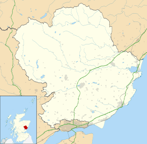
Arbirlot (Gaelic: Obar Eilid) is a village in a rural parish of the same name in Angus, Scotland. The current name is usually presumed to be a contraction of Aberelliot[1]:467 or Aber-Eliot [2]:147- both meaning the mouth of the Elliot.[lower-alpha 1] It is situated west of Arbroath. The main village settlement is on the Elliot Water, 2.5 miles from Arbroath. There is a Church of Scotland church and a primary school. The school lies 1 mile further west in the approximate geographic centre of the parish.
Geology and Landscape
Arbirlot village, sometimes known as Kirkton of Arbirlot, lies in the Kelly Den, formed by the Elliot Water. The principal underlying rock formation is Old Red Sandstone and Arbirlot attracted the attention of early geologists because of the exposed rock formations in the Kelly Den. Hugh Miller describes the rock formations in the "pastoral village of Arbirlot" in detail in his highly influential 1841 book Old Red Standstone.[5]:168–170
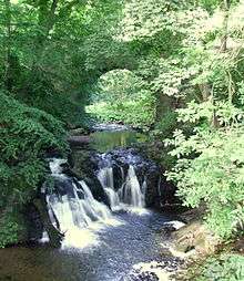
A nature trail by the Elliot Water links Arbirlot with the former railway junction of Elliot on the Angus Coast. Arbirlot holds host to a spectacular 23 foot waterfall.
History
There is extensive evidence of prehistoric occupation of the Arbirlot area. The First Statistical Account refers to the recent demolition of a "druidical temple" in the parish, the finding of a "Pictish crown", and the presence of numerous stone cairns.[1]:476 Historic Environment Scotland's Canmore database interprets the reference to the "druidical temple" as possibly referring to a stone circle and based on place-name evidence gives a possible location near to Cairncortie in the north-west of the parish.[6] The Second Statistical Account mentions the finding of many stone arrowheads in the parish.[7]:333 There is a cup and ring marked boulder near Craigend.[8]
There are cropmark indications of a possible Roman marching camp to the west of Grahamston Cottages.[9]:336
The current manse garden contains a standing stone (illustrated) with what are thought to be medieval carvings. The stone was retrieved from the foundations of the parish church during re-building works in 1831.[10]
The parish suffered from the effects of the First War of Scottish Independence in the late 13th and early 14th centuries as evidenced by the relief granted to the vicar of Arbirlot in March 1323 who was then twenty years in arrears in paying the two merks[lower-alpha 2] due annually to the Abbot of Arbroath Abbey. The relief was granted on the grounds of "the poverty, sterility, and destruction of the parish and its inhabitants, occasioned by the late war".[4]:201
Kelly Castle (sometimes Kellie Castle or Auchterlony Castle),[11] which overlooks the Elliot Water, comprises a four-storey tower of the late 15th or early 16th Century, set within a 19th-century courtyard. It was a stronghold of the Mowbray family until forfeited to the Stewarts in the early 14th century and was restored from a semi-ruined state [11] by the Earl of Dalhousie in the 19th century.
In the 18th and 19th centuries Arbirlot was principally occupied by handloom weavers and farmers, Arbirlot once had a meal mill, a slaughterhouse, two schools, a post office, a savings bank, an inn, a parish library as well as a number of shops.[1][7]
The parish is believed[2]:147 to be the original home of Clan Elliot, which was transplanted in the Scottish Borders to defend the newly crowned Robert the Bruce's Scotland from English invaders through an intricate network of peel towers. The Elliots joined the clans of Armstrong, Scott, Douglas, Kerr, Nixon, Hepburn and Maxwell in this effort. The Border Reivers and other titles such a Outlaws of the Marshes are most informative about the Elliots and their exploits after leaving the Arbirlot parish.
Notable natives and residents
- George Gladstanes c.1562 – 1615, minister in Arbirlot c.1592 - 1597, afterwards Bishop of Caithness and later Archbishop of St Andrews
- John Guthrie c. 1580 - 1649, minister in Arbirlot 1603 - 1617, afterwards Bishop of Moray. Supporter of Charles I's religious policies.
- Alexander McGill (c.1680-1734), mason and architect. First City Architect of Edinburgh.
- Rev Thomas Guthrie 1803 – 1873, divine and philanthropist, minister in Arbirlot 1827–1837
- Rev John Kirk 1795–1858, divine and biographer (of Susannah Wesley mother of John Wesley, The Mother of the Wesleys, Jarrold, London 1868), Church of Scotland minister in Arbirlot 1837 – 1843 and later first Free Church of Scotland minister in Arbirlot
- Alexander Carnegie Kirk 1830 - 1892, engineering innovator - particularly of the marine triple expansion steam engine. Elder son of the Rev John Kirk
- Sir John Kirk 1832 – 1922, physician, naturalist, companion to explorer David Livingstone, diplomat, slavery abolitionist and photography pioneer, lived with his parents in Arbirlot as a young man. Younger son of the Rev John Kirk.
- Eileen Ramsay (born 1940), novelist

See also
Arbirlot Railway Station
Arbirlot Primary School
Elliot Water
List of listed buildings in Arbirlot, Angus
References
Ordnance Gazetteer of Scotland: A Survey of Scottish Topography, Statistical, Biographical and Historical, edited by Francis H. Groome Thomas C. Jack, Grange Publishing Works, Edinburgh between 1882 and 1885
- 1 2 3 Statistical Account of Scotland, edited by Sir John Sinclair of Ulbster, Edinburgh 1791-99
- 1 2 The Annals of a Border Club (The Jedforest) and Biographical Notices of the Families Connected Therewith, George Tranced of Weens, T S Smail, Jedburgh 1899
- ↑ History of Arbroath, George Hay, Thomas Buncle, Arbroath 1876
- 1 2 Arbroath and its Abbey, David Miller, Thomas Stevenson, Edinburgh 1860
- ↑ Old Red Sandstone, Hugh Miller, Fairly Lyall & Co, Edinburgh 1841
- ↑ "Canmore". Canmore. Retrieved 23 October 2015.
- 1 2 New Statistical Account of Scotland, General Assembly of the Church of Scotland , Edinburgh 1834-45
- ↑ "Canmore". Canmore. Retrieved 23 October 2015.
- ↑ Jones, Rebecca (2011). Roman Camps in Scotland. Edinburgh: Society of Antiquaries of Scotland. ISBN 9780903903509.
- ↑ Coutts, H (1970). Ancient Monuments of Tayside. Royal Commission on Ancient & Historical Monuments of Scotland. p. 68.
- 1 2 RCAHMS Canmore Database - see External Links
Notes
- ↑ However alternative spellings used in the past may not support the "mouth of the Elliot" theory. Timothy Pont's map 26 Lower Angus & Perthshire east of the Tay ca 1583-1614 gives the name of the village as Ardbirlet Kirktoun as does the Blaeu Atlas of Scotland of 1654. This spelling would suggest a different origin for the name. The spelling of historic placenames in the area is notoriously unreliable, for example Hay's History of Arbroath[3] notes that the monks of Arbroath Abbey spelt the name of their own town 32 different ways in a single document - Registorum Abbacie de Aberbrothoc. Miller's Arbroath and its Abbey[4] lists Abereloth, Abireloth, Aberheloth, Aberhelot, Abrellot, Aberellot, Abberellot, Abbirlot, Abbirellot, Abirloth, Arbirloth, Abyrelloth, Arbirlot as samples of the variations in the spelling of Arbirlot in monastic sources.
- ↑ A total of £26 13s 6d Scots
External links
| Wikimedia Commons has media related to Arbirlot. |
- Description of Arbirlot Parish Church
- Description of the former Arbirlot Free Church
- Church website
- Parish Records
- Arbirlot in the First Statistical Account of Scotland
- Arbirlot in the Second Statistical Account of Scotland
- Kelly Castle record at Royal Commission on the Ancient and Historical Monuments of Scotland