Aranui
| Aranui | |
|---|---|
 Aranui | |
| Coordinates: 43°30′33″S 172°42′22″E / 43.50917°S 172.70611°ECoordinates: 43°30′33″S 172°42′22″E / 43.50917°S 172.70611°E | |
| Country | New Zealand |
| Region | Canterbury |
| Territorial authority | Christchurch City |
| Ward | Burwood-Pegasus |
| Population (2013 census)[1] | |
| • Total | 3,810 |
Aranui is one of the eastern suburbs of Christchurch. It is a lower socio-economic area.[2][3]
Etymology
Aranui is a Māori word, with ara meaning path and nui meaning great.[4]
History
Part of the area was previously called Flemington, named after the hairdresser and tobacconist Jubal Fleming (c.1844–1903).[5][6] Fleming had a subdivision at the corner of Breezes and Pages Roads, and the tram stop on Breezes Road was informally called Flemington. The post office was established in 1912 and it was named Aranui by George Kyngdon Burton (c.1859–1957), with that name then applied to the wider area.[6]
Mabel Howard, New Zealand's first woman cabinet minister, was once a resident in the area.[7]
Geography
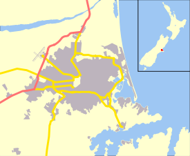
Aranui is one of the eastern suburbs. Its eastern boundary is the Avon River. Boundary roads are Pages Road in the south, Breezes Road in the west, and Wainoni Road in the north.[8] Bexley is located to the south of Pages Road.[9] Aranui and its neighbouring suburb of Wainoni are often considered together. For example, Wainoni School and Wainoni Park are located in Aranui, and Aranui High School is located in Wainoni. Christchurch City Council publishes a combined community profile for the two suburbs.[10]
Education
Aranui School is a primary school located on Breezes Road. St James School is a primary school located on Rowan Avenue. Wainoni School is a primary school located on Eureka Street. Aranui School, Avondale School in the adjacent suburb of Avondale, Wainoni School and Aranui High School will merge to become a Year 1–13 composite school on the Aranui High site in January 2017.[11]
References
- ↑ Population reported for Aranui from StatisticsNZ-Quickstats-Aranui-2013-Census. Statistics New Zealand, retrieved 12 Feb 2015.
- ↑ "Emergency Relief Centre". grace vinyard church. Retrieved 12 March 2011.
- ↑ "Christchurch Mayor: Nobody has been forgotten". 3 News. 2 March 2011. Retrieved 12 March 2011.
- ↑ Reed, A. W. (2010). Peter Dowling, ed. Place Names of New Zealand. Rosedale, North Shore: Raupo. p. 27. ISBN 978-0-14-320410-7.
- ↑ "Pars about People". Observer. XXIII (32). 25 April 1903. p. 4. Retrieved 30 September 2011.
- 1 2 Harper, Margaret (July 2011). "Christchurch Place Names" (PDF). Christchurch City Libraries. Retrieved 30 September 2011.
- ↑ "History". Aranui Community Trust Incorporated Society. Retrieved 12 March 2011.
- ↑ "Boundary Map of Aranui". Statistics New Zealand. Retrieved 4 May 2012.
- ↑ "Boundary Map of Bexley". Statistics New Zealand. Retrieved 4 May 2012.
- ↑ "Community profile Aranui/Wainoni" (PDF). Christchurch City Council. Retrieved 5 October 2013.
- ↑ "Eight Chch schools merge into two". 3 News NZ. 11 September 2013. Retrieved 16 September 2013.