Arang Kel
| Arang Kel | |
|---|---|
| Village | |
 | |
 Arang Kel | |
| Coordinates: 34°48′23″N 74°20′46″E / 34.8063°N 74.3460°E | |
| Country |
|
| State | Azad Kashmir |
| District | Neelam |
| Elevation | 2,554 m (8,379 ft) |
| Languages | |
| • Official | Pahari Koshur Urdu |
| Time zone | PST |
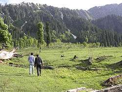
Arang Kel includes more than an hour of trekking to reach
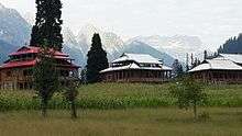
Arang Kel is a lush green village, hill station and tourist spot in Neelam valley, Azad Kashmir, Pakistan. It is located on the hill top near Kel at the altitude of 8,379 feet (2,554 m) feet.[1]
The village is accessible by a 2 kilometers (1.2 mi) trek from Kel.
See also
References
- ↑ "Neelum Valley". AJK Tourism & Archaeology Department. Retrieved 28 July 2013.
| Wikimedia Commons has media related to Arang Kel. |
Coordinates: 34°48′23″N 74°20′46″E / 34.8063°N 74.3460°E
This article is issued from Wikipedia - version of the 12/2/2016. The text is available under the Creative Commons Attribution/Share Alike but additional terms may apply for the media files.