Ar-Rutba District
This article is about the district. For the town, see Ar-Rutbah.
| Ar Rutba District | |
|---|---|
| District | |
|
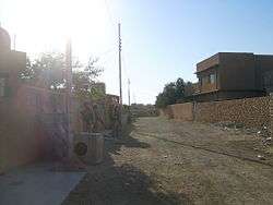
Street scene in Ar Rutba town (2004) Ar Rutba is the largest, southernmost and westernmost of the districts in Al Anbar Governorate | |
 | |
| Coordinates: IQ 33°2′17″N 40°17′4″E / 33.03806°N 40.28444°ECoordinates: IQ 33°2′17″N 40°17′4″E / 33.03806°N 40.28444°E | |
| Country |
|
| Governorates | Al Anbar Governorate |
| Seat | Ar Rutba |
| Area | |
| • Total | 93,445 km2 (36,079 sq mi) |
| Population 2003-01 (est.) | |
| • Total | 24,813 |
| • Density | 0.27/km2 (0.7/sq mi) |
| Time zone | AST (UTC+3) |
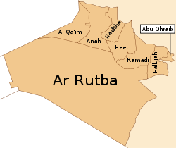
Ar Rutba (Arabic: قضاء_الرطبة) is the largest district by area in Al Anbar Governorate, Iraq, covering 93,445 km², and the least populated in relative and absolute terms, with a population of 24,813 (estimate January 2003), or 0.27 per km².[1] It is also the southernmost district of Al Anbar Governorate, the westernmost of the whole country, and the only district nationwide bordering Jordan. It is centred on the town of Ar Rutba.
Cities
References
This article is issued from Wikipedia - version of the 8/4/2016. The text is available under the Creative Commons Attribution/Share Alike but additional terms may apply for the media files.