Aqarib
| Aqarib عقارب Aqarib al-Safiyah | |
|---|---|
| Village | |
 Aqarib Location in Syria | |
| Coordinates: 35°06′15″N 37°12′38″E / 35.104133°N 37.210547°ECoordinates: 35°06′15″N 37°12′38″E / 35.104133°N 37.210547°E | |
| Country |
|
| Governorate | Hama |
| District | Salamiyah |
| Subdistrict | Sabburah |
| Population (2004) | |
| • Total | 3,830 |
| Time zone | EET (UTC+2) |
| • Summer (DST) | EEST (UTC+3) |
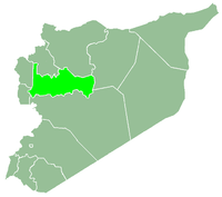
Aqarib (Arabic: عقارب, also known as Aqarib al-Safiyah (Arabic: عقارب الصافية) is a town in northern Syria, administratively part of the Hama Governorate, located 45 kilometres (28 mi) east of Hama at the edge of the Syrian Desert. Nearby localities include al-Salamiyah and Tell al-Tut to the southwest, Uqayribat to the southeast and Sabburah to the north. According to the Syria Central Bureau of Statistics, Aqarib had a population of 3,830 in the 2004 census.[1] Its inhabitants are predominantly Ismailis.[2]
Aqarib was founded in the late 19th century by Ismaili migrants from the area of Shaizar, a town west of Hama. The Ismailis had been evicted from their homes by a prominent landowning family based in Hama who owned the area around Shaizar. Part of the reason the migrants chose to settle in Aqarib was its proximity to al-Salamiyah, the center of Ismaili life in Syria.[2]
References
- ↑ General Census of Population and Housing 2004. Syria Central Bureau of Statistics (CBS). Hama Governorate. (Arabic)
- 1 2 Douwes, Dick (2010), "Modern History of the Nizari Ismailis of Syria", in Farhad Daftary, A Modern History of the Ismailis: Continuity and Change in a Muslim Community, I. B. Tauris, ISBN 9780857735263

